
- The sugar cane area of the municipality of Othón P. Blanco reflects the results of decades of government policies that have privileged agriculture and livestock over jungles and forests.
- Starting in the 1970s, the federal government promoted sugar cane cultivation in the region. Although many sugar cane fields have been established since the ‘80s, this monoculture has continued to take over hectares inside and outside the sugar cane area. The sugar mill, to this day, marks life in the southern zone of Quintana Roo.
- In the entire municipality of Othón P. Blanco, since 2010, 75,364 hectares (186,228 acres) have been left without tree cover, equivalent to 109 times the area of the Chapultepec Forest located in Mexico City.
May is about to end. There are no trees that provide shade to reduce the heat that exceeds 30 degrees Celsius (86 degrees Fahrenheit). José Jesús Pérez Castro walks along the edge of the already burned sugar cane plot, ready to be cut. The proud cane grower wears a hat, dark glasses and an impeccable gray polo shirt. He asks three cutters to pose for a photograph; they, covered in soot and with looks of bewilderment, agree.
Pérez Castro’s cultivation field is located in Sergio Butrón Casas, one of the 15 ejidos (common lands) that make up the so-called “sugar cane zone,” a territory in the south of Quintana Roo, along the banks of the Hondo River, right on the border with Belize.
Pérez Castro, like all those who grow cane in this area, sells all his production to the sugar mill that has been operating in the region since 1978. In the cane field, which is never-ending, the producer enthusiastically remarks that this region has planted cane for more than 40 years. And it is true.
These lands today are part of the municipality of Othón P. Blanco, considered for a long time as one of the critical points for forest loss; the result of decades of government policies that have favored agriculture and livestock is reflected above jungles and forests.

Deforestation as government policy
To understand how sugar cane took root in the municipality of Othón P. Blanco, it is necessary to review part of the recent history of this territory.
In the 1970s, during the presidency of Luis Echeverría Álvarez (1970-76), migrants from other states began to settle in the southern zone of Quintana Roo. The government then promised to give them land if they came to populate those jungle-dominated regions.
“Each ejidatario [a shareholder of common land] was given 10 hectares (25 acres) to plant and 2 ha (5 acres) for livestock. Three thousand ha (7,400 acres) were felled for cultivation. Rice was planted first. Now, most of it is just sugar cane,” says ejidatario Carmelo García, born in 1947 in Veracruz and arrived in the area now occupied by the Ejido Sacxan in January 1975.
The policy that led to populating territories such as southern Quintana Roo was accompanied by the National Clearing Program, which, between 1972 and 1983, promoted the clearing of forests to transform them into pastures for cattle and fields for mechanized agriculture.

In this context, the 15 ejidos that today make up the sugar cane area of Quintana Roo were created. It was also in those years when the federal government built the Álvaro Obregón Sugar Mill, which in 1988 was privatized and renamed as San Rafael de Pucté Sugar Mill.
Thus, since the late 1970s, but especially during the 1980s, the cultivation of rice, habanero peppers, corn and later sugar cane led to large areas of the Maya jungle in southern Quintana Roo becoming fields of cultivation. Currently, this transformation has a different rhythm.
“There are no longer these big changes in land use [due to sugar cane cultivation], but there is, what I call, petty deforestation. Each sugar cane grower clears half a hectare, 1 hectare, or maybe 2 hectares. Still, suppose you add up what 200 sugar cane growers do. In that case, the impact is not reported,” explains Pedro Antonio Macario Mendoza, a researcher on forest dynamics at the College of the Southern Border (ECOSUR).
The change of jungle for sugar cane fields has been spreading little by little outside what was traditionally considered the sugar cane area. An example of this is what happened in Laguna Om. In the forestlands of this ejido, people who presented themselves as representatives of the company that operates the San Rafael Pucté Mill, the sugar giant Beta San Miguel, cleared around 2,000 ha (4,4942 acres) of lowland forest in 2009.
Arrive, buy and deforest
The Ejido Laguna Om, adjacent to the limits of Campeche, is a bastion for conserving the Maya jungle, having 35,000 ha (86,487 acres) of low and medium forests certified as an Area Voluntarily Destined for Conservation since 2019. In addition, the ejido is a pioneer at the regional level in the sale of carbon credits, with which it seeks to compensate the population that keeps their lands intact financially. With all this, Laguna Om is also one of the main red spots of deforestation in Quintana Roo.
Between 2001 and 2021, this ejido was left without 9,357 ha (23,120 acres) of tree cover, according to an analysis by Global Forest Watch (GFW) and the World Resources Institute (WRI-Mexico), shared with Mongabay Latam for this journalistic project. The ejido registered a more significant forest loss in 2009 and 2017.
It was precisely in 2009 when ejidatarios from Laguna Om and people who presented themselves as Grupo Beta San Miguel representatives led a conflict over the clearing of 2,000 ha of the jungle intending to plant sugar cane.

Macario Mendoza, as an ECOSUR researcher, is an ejidatario of Laguna Om. He recalls that attempts to acquire ejido lands for sugar cane planting began in 2003. At that time, an agreement was not reached since the offer received by the ejido was 1,600 pesos per hectare ($152, according to the exchange rate for that year).
In 2008, the then-ejidal commissioner Gualberto Caamal Ku negotiated with those who claimed to represent the Beta San Miguel Group. The payment proposal increased to 10,000 pesos per hectare ($925). This is how, in the assembly, most of the ejidatarios voted to sell around 2,000 ha.
To finalize this transaction, ejidal rights were sold to five people who presented themselves as part of Beta San Miguel, Caamal Ku, who is currently, once again, an ejidal commissioner, confirmed in an interview.

Article 64 of the Agrarian Law indicates that ejido lands are inalienable; they cannot be bought or sold as private property. However, the law allows ejidatarios to sell their ejido rights only to other ejidatarios or residents, that is, people who have resided in the ejido for more than one year.
The representatives of the sugar company were never residents. People in the community don’t know who they are. “We don’t know them here, we’ve never seen them, everything was done through their lawyers,” says an ejidatario from Laguna Om who asks not to make his identity public for fear of reprisals.
Even so, ignoring what the agrarian law establishes, the sale of ejido lands was carried out. “They bought the rights of neighbors (ejidatarios). The assembly was informed, the assembly accepted, and they made the payment,” argues Camaal Ku.
Once the deal was closed, the buyers of the land put machinery on the ground and made controlled burns to prepare the area for sugar cane cultivation. According to Macario Mendoza, several people from the community, including some ejidatarios, did not agree with the irregular sale of the lands or the clearing.
Added to this was the fact that the clearing of the land was carried out without having the authorization to change the use of forestland. This permit must be requested from the Ministry of Environment and Natural Resources (SEMARNAT). Logging without that authorization is considered a crime.
On April 15, 2009, 11 people linked to the mill were arrested, but days later, they were released, according to ejidatarios. Members of the ejidal assembly had to take steps before the federal and state governments to avoid the fine that Federal Attorney for Environmental Protection (PROFEPA) imposed on Laguna Om for the illegal change of use of forestland.
The consulted ejidatarios ensured that the company used the land left without the forest to plant sugar cane for a while. Today they are in disuse.
On its website, Proal, Productora de Alimentos S.A de C.V., a subsidiary of Ingenio San Rafael Pucté, reports that Laguna Om also has two other sugar-producing ranches: El Corozal and Las Mil. The current ejido commissioner says these are located on land where rice was planted before. In addition, the company owns the El Aric ranch, situated on land belonging to Ejido Sabidos in the sugar cane area.
To find out the version of the mill’s representatives about the 2,000 ha cleared in Laguna Om, Mongabay Latam sought to contact a representative of Grupo Beta San Miguel or Proal through different means but has yet to receive a response. The receptionists in his offices in Mexico City reported that all the staff worked from home, so there was no one to attend the interview request.

Stretching reedbeds
In the sugar cane region of southern Quintana Roo, during the tillering period (cane growth stage), the green plants cover the lands that once housed cedars, mahogany, ceibas or chicozapotes.
In the municipality of Othón P. Blanco, sugar cane production has been increasing over time: While 21,784 ha (53,829 acres) were planted in 2010, in 2021, the area was 33,114 ha (81,826 acres), according to data from the Agri-Food and Fisheries Information Service (SIAP). In 2022, 36,000 ha (88,960 acres) were allocated to this crop, according to Evaristo Gómez Díaz, representative of the Local Union of Sugar Cane Producers.
The document titled “Analysis of Deforestation Processes in Quintana Roo between 2003-2018,” carried out by the Mexican Civil Council for Sustainable Forestry, the Center for Research in Geospatial Information Sciences (CentroGeo) and edited by the National Forestry Commision (CONAFOR), pointed out that the growth of sugar cane cultivated area in the state has been encouraged by the increase in sugar cane prices.
“Unfortunately, high prices encourage more deforestation,” remarks Edward Ellis from the Center for Tropical Research at Veracruz University, who for more than a decade has studied the processes of loss and degradation of forest cover in the Yucatán Peninsula.
Producers such as José Jesús Pérez Castro, as well as ejidatarios from Othón P. Blanco and even former officials of environmental agencies in the entity, assure that the jungle has not been deforested to extend sugar cane crops in the region. They attribute the increase in the area planted with canes to the reconversion of plots already used to grow rice, corn and beans.
Analysis of satellite images for this journalistic project shows that many cane fields have been in the region for several decades. Still, it is also possible to corroborate what Macario Mendoza calls “petty deforestation”: jungle spaces slowly and discreetly lose ground while sugar cane crops advance.
The GFW and WRI-Mexico analysis shows that since 2010, 33,259 ha (82,185 acres) of tree cover have been lost in the 15 ejidos that make up the sugar cane zone. In the entire municipality of Othón P. Blanco, since 2010, it is estimated that 75,364 ha (186,228 acres) have been left without tree cover, equivalent to 109 times the surface of the Chapultepec Forest, located in Mexico City.
In this municipality, the most critical years for the forest have been 2017, when 13,122 ha (32,425 acres) were left without tree cover, as well as 2019 and 2020, with a loss of 9,000 ha (22,240 acres) each year.
In Othón P. Blanco, according to the Analysis of Deforestation Processes in Quintana Roo between 2003 and 2018, the most significant changes in forestland use were caused by the sugar mill and government institutions’ impulse to “plant cane sugar and livestock production.”
A mill that traces the life of a region
From a distance, you can see significant fumes coming out of the San Rafael Pucté Sugar Mill facilities. Up close, smoke aggravates the lungs.
In southern Quintana Roo, life revolves around sugar cane and the presence of the sugar mill that the federal government built in the early 1970s on land that was expropriated from the Álvaro Obregón and Pucté ejidos, 65 kilometers (40 miles) from the city of Chetumal.
In November 1988, taking advantage of the privatization process that characterized the six-year term of Carlos Salinas de Gortari (1988-94), the Beta San Miguel Group acquired four mills, one of them in Quintana Roo, which it named San Rafael de Pucté. Today the company has eleven mills and is the leading sugar manufacturer in Mexico.
The San Rafael de Pucté mill buys all the crops produced in the municipality of Othón P. Blanco and Bacalar. According to information from the company, it receives raw materials from more than 2,800 sugar cane growers and employs close to 400 people in its plant. According to data from the state government, sugar cane production generates around 30,000 direct and indirect jobs in the southern region of Quintana Roo.

During the harvest season, the mill operates every day, including Saturday and Sunday. In its facilities, the cane is crushed and ground to obtain the juice. It is stored, filtered of impurities and evaporated at very high temperatures to crystallize and materialize in sugar grains.
During the 2021 sugar cycle to July 30, 2022, the company milled 1,774,069 tons of cane. It produced 183,692 tons of sugar, according to figures from the Ministry of Agriculture and Rural Development. Its yield was 54.3 tons per hectare, meager compared with the 105 or 95 and 80 tons per hectare registered by mills in Puebla, Jalisco and Chiapas, respectively.
The economic agreements between the producers and the mill occur under “agriculture by contract”; that is, both parties establish the area to be planted and the tonnage of cane the producers must deliver.

The producers sign their contract through one of the two trade union organizations in the region: the Local Union of Sugar Cane Producers and the Association of Sugar Cane Producers of the Ribera del Río Hondo.
The mill also grants the producers financing to carry out the planting. This is through the financial company Unagra S.A de C.V. The company gives credits to the producers, among other things, to pay the reapers and to finance the “technological package,” that is, the genetically improved seeds, irrigation systems, fertilizers and machinery.
The profits of a sugar cane producer depend on how many hectares he sows and the productivity of his plots, explains Martín Barajas, former secretary of the Quintana Roo Sugar Cane Union. It also depends on the mill’s discounts: “When you deliver your canes,” explains producer Carmelo García, “the mill does the math and charges you what it gave you, with interest, and pays you the rest.”

Bacalar: Territory that today loses jungle
According to the most up-to-date public data from the National Forest Monitoring System, Quintana Roo stands out on national maps for its forest cover: Nearly 78% of its territory was covered by forest in 2016. The state also stands out for being one of the entities in the country with high and accelerated forest loss.
Between 2003 and 2018, Quintana Roo had a loss of 194,006 ha (480,000 acres) of rainforests, an area that is equivalent to four times the territory of the island of Cozumel; 45.6% of that area (88,466 ha, or 218,604 acres) was transformed into agricultural land, according to an analysis of deforestation processes in the state, published by CONAFOR.
Between 2010 and 2021, the municipality of Bacalar alone lost 84,727 ha (209,360 acres) of tree cover, according to analyses carried out by GFW and WRI-Mexico.
In the document “Analysis of Deforestation Processes in Quintana Roo,” edited by CONAFOR, agricultural activity is identified as the leading cause of changing land use in Bacalar.
The history of agribusiness in Bacalar is recent. Before 2013, this municipality did not appear in the SIAP reports. Until that year, it reports having 17,574 ha (43,424 acres) planted, mainly with corn (12,660 ha or 31,284 acres) and soybeans (2,101.5 or 5,193 acres), crops that until 2021 were predominant in that territory where sugar cane also began to have a discreet presence.
The existence of sugar cane fields in Bacalar was officially registered in 2018. That year, 1,160 ha (2,866 acres) were planted. In 2021, that area decreased to 900 ha (2,223 acres).
Promoting sugar cane in Bacalar is associated with the support that the Ministry of Agriculture and Rural Development gave the crop. In a statement from the agency on Oct. 23, 2018, it was reported that the Agricultural Development Program would facilitate the acquisition of machinery, irrigation systems and technological packages.
In Bacalar, the beneficiaries of this program were the ejidos San Román and Blanca Flor (La Buena Fé). For every 44 ha (108 acres), support of 748,000 pesos (around $37,000 at that time) was given.

Weaken an ecosystem
Researcher Macario Mendoza has been a Quintana Roo State Forestry Council member since 1990 as a representative of ECOSUR. Within that council, he comments that attempts have been made at different times to transform some land in the low jungle into agricultural areas.
Approximately 14 years ago, recalls Mendoza, representatives of sugar cane producers sought a favorable opinion from the council for clearing 5,000 ha (12,355 acres) of the jungle to extend the sugar cane production zone. One of the applicants represented the National Confederation of Rural Producers and another, the Local Union of Sugar Cane Producers. However, the request was denied.
The ECOSUR researcher explains that the low forests, a maximum of 15 meters (49 feet) high, are home to a great wealth of biodiversity. “They are the best preserved in Quintana Roo and the Yucatán Peninsula because they are flooded jungles; it is difficult for the fires to progress because there is no leaf litter to burn, nor do hurricanes do them that much damage because they are short jungles. Those forests are fascinating for crops because they are flooded and require much water.”

Trees are only one of the things that need to be added. The medium and low jungles of Quintana Roo constitute complex ecosystems. The publication “Biological Wealth of Quintana Roo: An Analysis for its Conservation”, edited in 2011 by ECOSUR and the National Commission for the Knowledge and Use of Biodiversity, recognizes that the process of deforestation on the banks of the Hondo River for cane plantations has caused impacts on the local fauna due to the loss of habitat. In addition, the continuity of the natural vegetation is almost completely lost in a strip that measures an average of 12 km (7.5 mi) wide by 45 km (28 mi) long.
This study highlights that “this loss of vegetation connectivity has led to the disappearance of populations of endangered mammal species previously widely distributed in the area, such as the tapir, spider monkey, black howler monkey, night monkey and white-lipped boar.”
A degraded forest loses its biodiversity and capacity to sequester carbon and provide environmental services, warns researcher Edward Ellis. The specialist offers information on how little is repaired when a forest area is felled: The recovery of a mature tropical forest can take up to 70 years.
In addition to degradation, monocultures also promote the intensive use of agrochemicals.
Eutimio Eúan has been a sugar cane producer for 24 years. He used to plant corn, but since “it didn’t pay off,” he decided to change crops. “The cane does pay,” he says. And as proof, he says that it has allowed him to have his own house, set up a store and send his children to school.
For the sugar cane producer, the environmental problems that exist in the southern region of Quintana Roo are more related to the use of agrochemicals than to clearing. “We had a problem,” he says, “because they used inappropriate herbicides that damaged the soil; all of that, they said, went to the streams, to the groundwater, which did damage the environment.”
The agrochemical the producer is talking about is glyphosate, a broad-spectrum herbicide considered a possible carcinogen by the World Health Organization. In the sugar cane region, they ensure that glyphosate is no longer applied, but other agrochemicals are used. Eutimio Eúan is even one of the producers using drones equipped with tanks to fumigate and fertilize their cane fields.
The mill is also the one that provides fertilizers and pesticides to the producers.
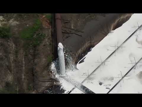
In his thesis, “Heavy Metals in Soils and Sediments in the Sugarcane Area of Southern Quintana Roo”, prepared in 2016, Gibran Eduardo Tun Canto documented the presence of mercury, lead, copper and iron in the soils of sugar cane plots. “The Hondo River, which flows into the southern portion of the Chetumal Bay, could be transporting waste from the sugar cane area, changing the quality of the water bodies of the basin and putting aquatic fauna and human health at risk,” is read in the academic work.
Territory marked by canes
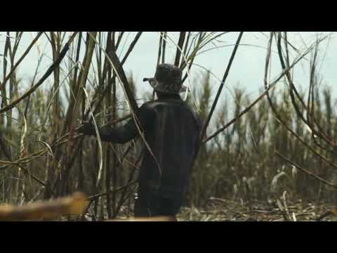
The men, covered in soot and bewildered, agree to have a picture taken with the cane producer José Jesús Pérez Castro; they earn their living cutting cane. When the harvest ends, most return to their places of origin. Like most reapers, they are migrants from Chiapas, Tabasco, Campeche or Veracruz.
In this region of southern Quintana Roo, migrants and their families who arrive for the harvest season live in shacks or cuarterías: buildings made up of small rooms with tin roofs, where a small fan can do little to cool the air. About a dozen of these shacks are along the banks of the Hondo River.
Producer Jesús Pérez Castro describes these camps as “habitable places for [the reapers] to live as a family as if they were at home.”

In one of the shacks in the community of Sergio Butrón Casas, Roberto tries to rest lying down in a hammock. He is 25 years old, originally from Campeche, and a migrant. His parents inherited the trade of cane cutting.
It’s Sunday, the only day off for Roberto, who asks to be called that. The six previous days, with a machete in hand, he dedicated himself to cutting cane from dawn until sunset at temperatures beyond 30 degrees Celsius.
“About 4 in the morning, one gets ready; you have to fix your lunch, then the car passes, you go to the reaping, and the corporal assigns you your pegada.” This is how they call the sections of six furrows where the cane will have to be cut, with one of the three machetes provided free of charge by the San Rafael de Pucté Mill or with one they had to buy because the ones they are given are not enough for the season.

The men end up with their skin smudged by smoke from the fires and their hands covered in calluses. The cane, says Roberto, must be cut flush because the sweet is in the trunk. “The payment depends on what you do. I make 500-600 pesos a day (around $30); those who don’t cut much make about 100-150 pesos (up to $8) a day,” he says.
The mill hires cane cutters. The producers ensure that when the reapers receive payment for the cane they deliver to the mill, among the various discounted things is a sum of 40 pesos for each reaper they have in their fields. A common complaint the reapers have is that they need social security.
Roberto waits for the harvest to end to migrate. He plans to travel north, try to cross the Rio Grande and reach California, United States. Unlike the migrants who came to this region in the 1960s and ‘70s, or the Mennonites who buy large tracts of land, he has few opportunities to get land and become a producer.
In this region of southern Quintana Roo, sugar cane monocultures determine the present and future of the people.
When this territory is observed from above, with the help of a drone or with satellite images, it is possible to see that despite the dominance of the reedbeds, the jungle still grows in certain areas that look like islands; in some areas, it is a kind of wall that protects archaeological zones and cenotes.
When you travel through the region by land, the fields inhabited by the thin trunks of the cane of the same size and similar colors contrast with the trees that do not let the sun rays pass, vines, plants at ground level, insects, birds and mammals that give identity to that jungle that can still be found in southern Quintana Roo.
Banner image: Sugar cane cultivation is one of the main economic activities in Quintana Roo. The expansion of this monoculture has environmental consequences for the forests. Image by Robin Canul.
This story was reported by Mongabay’s Latam team and first published here on our Latam site on Aug. 31, 2022.