
- Mongabay is publishing a new edition of the book, “A Perfect Storm in the Amazon,” in short installments and in three languages: Spanish, English and Portuguese.
- Author Timothy J. Killeen is an academic and expert who, since the 1980s, has studied the rainforests of Brazil and Bolivia, where he lived for more than 35 years.
- Chronicling the efforts of nine Amazonian countries to curb deforestation, this edition provides an overview of the topics most relevant to the conservation of the region’s biodiversity, ecosystem services and Indigenous cultures, as well as a description of the conventional and sustainable development models that are vying for space within the regional economy.
- This is part of chapter 1 of “A Perfect Storm in the Amazon,” see the bottom of this page for links to all the excerpts.
A tropical rainforest is composed of thousands of species of long-lived trees, each with a natural history characterized by unique morphological, physiological and reproductive attributes. Very little was known about the ecological processes within these plant communities in 1980 when ecologists began to establish long-term studies to document their composition, structure and function.
In one project near Manaus, scientists created an experiment to evaluate the impact of deforestation and forest fragmentation on plant and animal communities. In another, dozens (eventually, hundreds) of botanists affiliated with local universities and research institutions created a network of hundreds (eventually, thousands) of permanent one-hectare plots scattered across the entire region.
They have used these plots to study Amazonian tree biodiversity, identifying which species are extraordinarily abundant (hyperdominant) and which are exceedingly rare, as well as documenting how tree communities vary across latitudinal, elevational and climatic gradients, information essential for understanding how the Amazon might change in the future due to global warming.
Because ecologists count trees and measure their dimensions, they have revealed the dimensions of the Amazon’s massive carbon reserves; more importantly, because they repeat their measurements periodically, they have discovered that the Amazon ecosystem has functioned as a net carbon sink over the last several decades. Surprisingly, they discovered that the photosynthetic capacity of intact primary forest was so great that wilderness landscapes have been sequestering more carbon on an annual basis than was being lost via deforestation and forest degradation on the forest frontier.
Unfortunately, these same studies identified a trend of increasing tree mortality and a shift in species composition that may cause intact primary forest to become a net source of carbon emissions over the next decade. The shift in ecosystem function is due, in part, to alterations in the physiological processes in leaves stressed by periodic drought and high temperatures but also due to a shift in the composition of tree species caused by increased tree mortality.
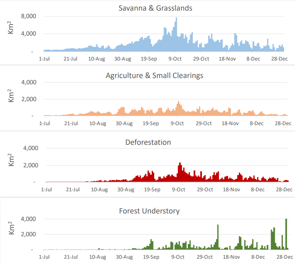
Investments in forest ecology were matched by parallel efforts to observe and evaluate forest landscapes using remote sensing technology. Brazil led the way in the early 1980s with a commitment to annually quantify deforestation using satellite images, a decision that would have an enormous impact on the public debate about the expansion of the agricultural frontier, as well as the decisions made in international forums dealing with climate change.
The protocols and technology developed by the Brazilian space agency have been adopted as a global standard and are now used by all the Pan Amazonian nations to monitor their own forest frontiers. Over time, innovation in remote sensing technology led to the deployment of satellite-borne sensors that could monitor deforestation in real time, as well as identify forest degradation from logging and wildfire. These studies complemented field research by forest ecologists, which allowed researchers to spatially map the distribution of forest biomass, as well as detect how seasonal and interannual variation in weather was impacting ecosystem function at the landscape, regional, and continental scales.
“A Perfect Storm in the Amazon” is a book by Timothy Killeen and contains the author’s viewpoints and analysis. The second edition was published by The White Horse in 2021, under the terms of a Creative Commons license (CC BY 4.0 license).
Read the other excerpted portions of chapter 1 here:
 Chapter 1. The state of the Amazon
- The state of the Amazon May 31, 2023
- Drivers of environmental degradation in the Amazon June 1, 2023
- The geography of environmental degradation in the Amazon June 7, 2023
- The political economy of the Pan Amazon June 8, 2023
- Understanding the conventional economy of the Pan Amazon June 13, 2023
- The natural history of the Amazon Rainforest June 14, 2023
- Forest ecology and carbon dynamics in the Amazon June 20, 2023
- Climate change and moisture recycling in the Amazon June 22, 2023
- Environmental policy and action on the ground in the Amazon June 27, 2023
- Environmental governance in the Amazon June 28,2023
- The largest land set-aside in history June 29, 2023
- An Indigenous revival in the Pan Amazon July 6,2023
- Monetizing nature: The under-explored power of the Amazon’s natural capital July 7, 2023
- The challenge of the future (and lessons from the recent past) in the Pan Amazon July 12, 2023
- Current policy approaches in the Amazon: certainly necessary, but are they sufficient? July 13, 2023