
- Researchers from the Amazonian Scientific Research Institute Sinchi analyzed the potential future of the Colombian Amazon Rainforest up until 2040; the results, based on analyzing 18 years of data from forest monitoring, show three possible future scenarios depending on deforestation policies.
- With current trends, loss could amount to 2.1 million hectares (5.2 million acres) of Amazon Rainforest. However, in the worst-case scenario — if extractivist policies are implemented — deforestation could reach 4.3 million hectares (10.6 million acres).
- On the other hand, if the cattle ranching industry is reduced and sustainable development achieved, at least 3.5 million hectares (8.6 million acres) of forest could be saved by 2040.
A recent study by the Amazonian Scientific Research Institute Sinchi in Colombia built several possible scenarios for the future of the Colombian Amazon by 2040. Experts who collected information during 18 years via the Colombian Amazon Land Cover Change Monitoring System (SIMCOBA) indicate that without implementing policies to control deforestation and other activities that harm the rainforest, at least 2.1 million hectares (5.2 million acres) of rainforest could be lost in the next two decades.
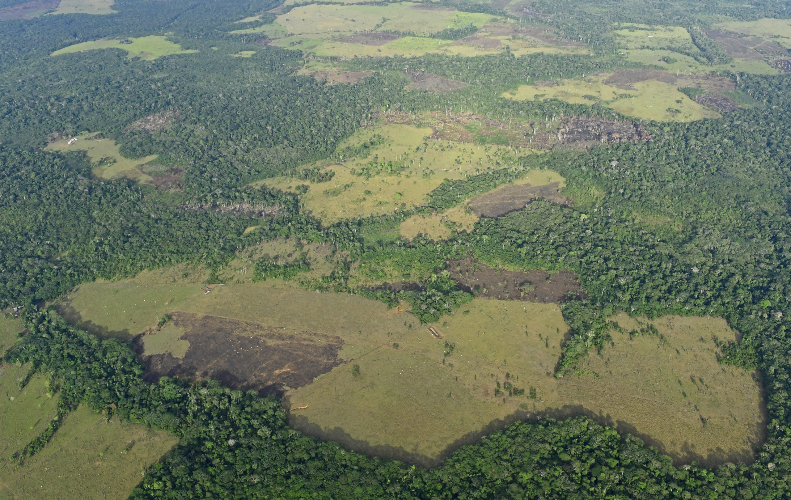
The expansion of pastures for cattle ranching has grown at an accelerated rate in the Colombian rainforest. Due to this growth, the government and the Revolutionary Armed Forces of Colombia (FARC) signed a peace agreement in 2016. Confirming some of the data in the study, this historic armed presence limited deforestation and controlled expansion of illegal activities like coca growing and illegal ranching. It also restricted commercial and subsistence farming. However, the dynamics of the land occupation, which were hidden during the conflict, are now becoming more obvious, speeding up land use changes.
Satellite monitoring shows that from 2017 to 2020, forest loss and the frequency of forest fires increased in this region, even in protected areas, giving access to extensive areas for pastures and secondary vegetation. Areas became fragmented, threatening regional connections between the Amazon, the Andes and the Orinoquía region.

“These two areas have been the subject of occupation and colonization, and as a result, trees have been cut down and the forest replaced with cattle ranches, which expand every year. This has advanced permanently,” says Uriel Murcia, coordinator of the Sinchi Institute’s Working Models and Sustainability program, and co-author of the study.
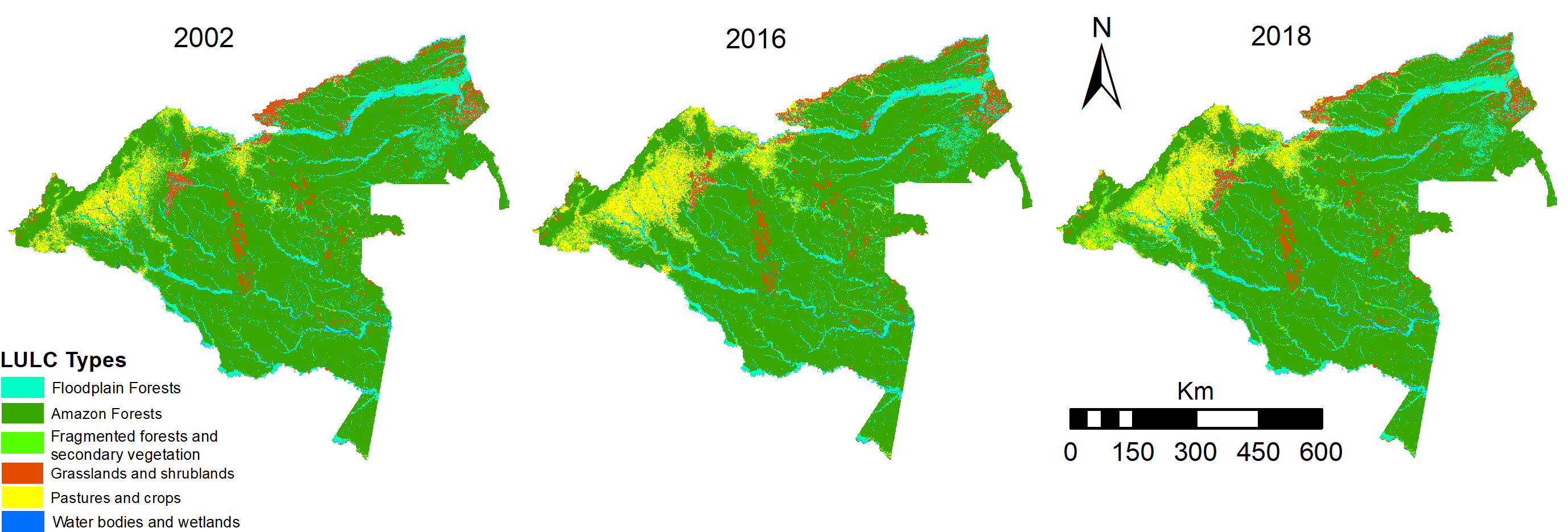
The Amazon deforestation monitoring system, which the institution has operated since 2002, has found that on average, 190,000 ha (470,000 acres) of pastures are sown on deforested areas every year.
“This dynamic of extensive ranching means that on average, it takes 2 ha [five acres] to maintain one head of cattle,” says Murcia. “It’s very inefficient economically, and environmentally it’s extremely harmful, because it’s transforming 2 ha of highly biodiverse equatorial or tropical native forests.”
The monitoring exercise led to a need for tools to interpret the information and define what will happen in the future. ”We have generated clear maps, which the public can interpret, but above all, which can be shown to local decision-makers — mayors, governors, directors of environmental authorities. The information lays out what is the impact of continuing business as usual, or what would be the impact if we change for the better or incentivize and intensify certain activities,” says the expert.

Three possible scenarios for the Colombian Amazon
Considering the post-conflict stage, specialists from the Sinchi Institute came up with three scenarios of land use change for the Colombian Amazon by 2040: trend maintenance, extractivist and sustainable.
In the first scenario, the trend maintenance scenario, which would keep the status quo, the experts suggest that without implementing policies to control deforestation and other activities that degrade the forest, at least 2.1 million ha of forest could be lost by 2040.
The second scenario assumes that extractivist development policies are promoted — i.e., incentivizing ranching and monocultures of soya and other grains, as it has happened in various regions of the Brazilian Amazon. In this instance, deforestation could impact 4.3 million ha (10.6 million acres) in the Colombian Amazon Rainforest.
The last scenario, based on sustainable development, would involve reducing cattle ranching to avoid new conversions of rainforest into pasture, restricting deforestation rates, incentivizing conservation agreements and promoting agroforestry production systems as well as reducing violence and strengthening local environmental leadership. This could avoid the deforestation of at least 3.5 million ha (8.6 million acres) of forest. Experts say that by implementing all these actions on the 39 million ha (96 million acres) of already transformed areas and creating new restoration areas that would favor secondary forests, a total of around 42 million ha (104 million acres) of forest could be preserved by 2040.
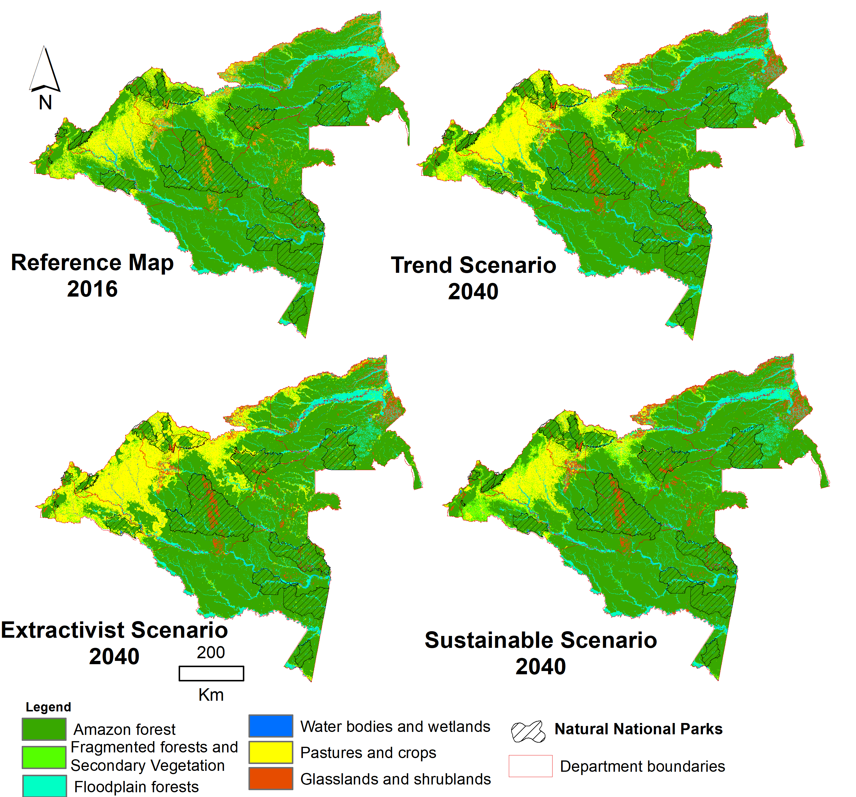
The research also confirms that in the trend maintenance scenario, pastures and farming could grow by 48%, while in the extractivist scenario, these would increase by 117%. That means the area taken up by pasture and farming would increase from currently 3.9 million ha (9.6 million acres) to 8.6 million ha (21 million acres).
The Sinchi Institute wants this data to play a part in informed decision-making. “We want this to be included in planning and legal documents so that we aren’t waiting until 2030 to make a change, but instead that decisions are made now to improve and redirect the whole issue of land use and occupation,” says Murcia.

How do maps depict the Amazon’s future?
“We had evidence not only of how much forest is being lost, but also where. This is the power of maps generated by SIMCOBA — they allow us to calculate the annual rates of forest loss and to find out where this is happening,” says William Agudelo Henríquez, principal researcher from the Sinchi Institute and co-author of the study.
Agudelo Henríquez says that by analyzing data on the quantity and location of rainforest loss between 2002 and 2016, they were able to create a model with high precision in predicting the future of current forests, and, by using mathematical probabilities, they were able to explore how they will be maintained or lost.
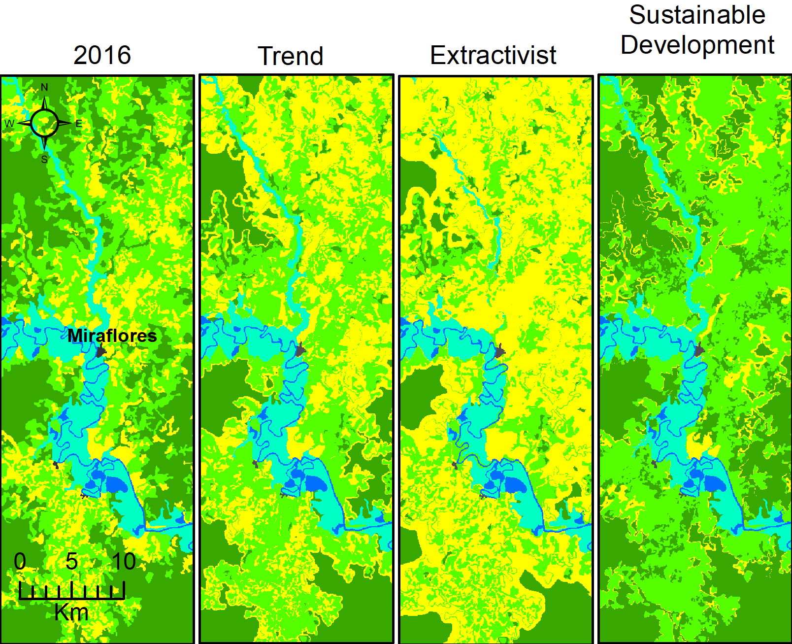
“Maps can be read differently, depending who is reading,” says Agudelo Henríquez. “Our intention is for the maps to have an impact on the local land — we hope they will be read by territorial entities like local councils and associations, who are, after all, the ones who are there. The map is at a very high resolution, so they can zoom in on their territory and compare the scenarios, to look at how their future will be. But maps can also carry a message to regional politics, in terms of the Colombian Amazon as a whole. It’s an invitation for authorities and institutions to be involved in conservation and make sure that their decisions have a positive impact on the future,” he adds.
One example of work that would enable a positive future for the Amazon Rainforest is working together with rural and peasant communities under an agro-environmental agreement. Agudelo Henríquez explains that this is something the Sinchi Institute has worked on since 2015 with communities in this region.
“This involves forest conservation agreements, but also work to promote alternative uses of land,” says the researcher. “We can’t only have extensive ranching. We need to prioritize the forest and the goods and services that it offers and plan how to use its land to its greatest potential, to advise on cattle ranching. This implies the conservation, restoration, production and rehabilitation of some areas of their land. We have enough experience to show that this is a viable route that, until now, has had positive results.”
Agudelo Henríquez highlights that one of the study’s most important messages is that we must stop deforestation, and we cannot tolerate any policy that allows it.
“Furthermore, the current government is already implementing policies around its new focus of working with rural communities in areas of highly active deforestation,” says Agudelo Henríquez. “Those are the two key elements that will guide the activities and land use in the Colombian Amazon in the short and medium term and determine which path it will follow. For now, we can see that we are heading toward a sustainable development model, and as the study suggests, this would avoid large areas of forest loss. Let’s hope that it’s successful.”

Citations:
Agudelo-Hz, W. J., Castillo-Barrera, N. C., & Uriel, M. G. (2023). Scenarios of land use and land cover change in the Colombian Amazon to evaluate alternative post-conflict pathways. Scientific Reports, 13(1), 2152.
Banner image: Forest loss and frequency of forest fires increased in Colombia. Image by Jorge Contreras.
This story was reported by Mongabay’s Latam team and first published here on our Latam site on Mar. 7, 2023.