
- A recent study has found that in the five-year period between 2021 and 2025, the Amazon could lose half the total forest cover it lost in the previous 20 years, amounting to a further loss of 237,058 square kilometers (91,529 square miles).
- From 2001-20, the rainforest lost more than 500,000 km2 (200,000 mi2) of forest cover, an area larger than Spain, mostly because of road development, agricultural expansion and mining.
- Deforestation rates continue to accelerate in almost all nine Amazonian countries, especially in Brazil, Bolivia, Peru and Colombia.
- Implementing efficient public policies and strengthening control and monitoring are essential to reduce rising deforestation rates, but experts warn economic interests often clash with conservation efforts in the Amazon.
Within just five years, the Amazon Rainforest could lose half the total forest cover that it lost in the first 20 years of this century, a recent study has shown, as deforestation rates continue to accelerate in almost all nine Amazonian countries.
From 2001-20, the rainforest lost 542,581 square kilometers (209,492 square miles), an area larger than Spain, according to data released in March by the Amazon Network of Georeferenced Socio-Environmental Information (RAISG). By extrapolating these past trends, the study predicted possible deforestation scenarios for the rainforest from 2021-25. In an optimistic scenario, the rainforest would lose 94,349 km2 (36,428 mi2) to clearing, while a pessimistic scenario would see 237,058 km2 (91,529 mi2) cleared, an area almost the size of the United Kingdom.
“Unfortunately, we are currently witnessing the pessimistic scenario,” Marlene Quintanilla, director of research and knowledge at the organization Friends of Nature and contributor to the study, told Mongabay by video call.

The highest rates of deforestation in the Amazon will continue to concentrate in Brazil, Bolivia and Peru, the study predicted. Indigenous territories (ITs) and protected natural areas (PNAs) will also remain negatively affected, with losses of up to 32,060 km2 (12,378 mi2) from 2021-25 — the equivalent of 2,460 soccer fields every day for five years.
“It’s potentially extremely serious because in most of the Amazon countries, the invasion of Indigenous lands and deforestation [are] already bad,” Fiona Watson, director of research and advocacy at Survival International, an NGO that champions Indigenous rights, told Mongabay by phone.
A troubling trajectory
The Amazon Rainforest sprawls across nine South American countries, covering a total of 8.5 million km2 (3.3 million mi2), including the Amazon Basin and transition zones into biomes such as the Andes mountain range and the Pantanal wetlands. In 2001, nearly three-quarters of this region was covered in forest spanning more than 6.2 million km2 (2.4 million mi2). By 2020, 9% of this forested area had been deforested, reducing it to less than 5.7 million km2 (2.2 million mi2), the study found.
Brazil, home to three-fifths of the rainforest, was responsible for more than 80% of all Amazon deforestation from 2001-20, totaling 440,031 km2 (169,897 mi2). The country with the second-highest rates of deforestation was Bolivia with 39,239 km2 (15,150 mi2), followed by Peru with 29,806 km2 (11,508 mi2). Agriculture and mining were the key deforestation drivers in these three countries.
ITs and PNAs, which the report described as “two of the most important management units in terms of the protection of natural ecosystems,” have also been impacted. Covering 56% of the Amazon, 14% of these areas were cleared from 2001-20, totaling 32,011 km2 (12,360 mi2) in ITs and 43,418 km2 (16,764 mi2) in PNAs.
“Command and control actions to combat and inhibit (mostly illegal) deforestation have been insufficient, as can be seen in the increase in vegetation loss and conversion rates for agricultural use in PNAs and ITs,” according to the study.
This is partly due to weakened environmental policies, as was the case in Brazil under former President Jair Bolsonaro’s administration from 2019-21, butforest loss was also intensified because of the COVID-19 crisis, experts say. “Little surveillance and forest monitoring due to the immobilization during the pandemic provoked an increase in illegal logging, mining and the invasion of forested areas,” Zuley Cáceres, an environmental specialist from IBC Peru, an NGO also involved in the RAISG study, told Mongabay by email.
Devastation from roads
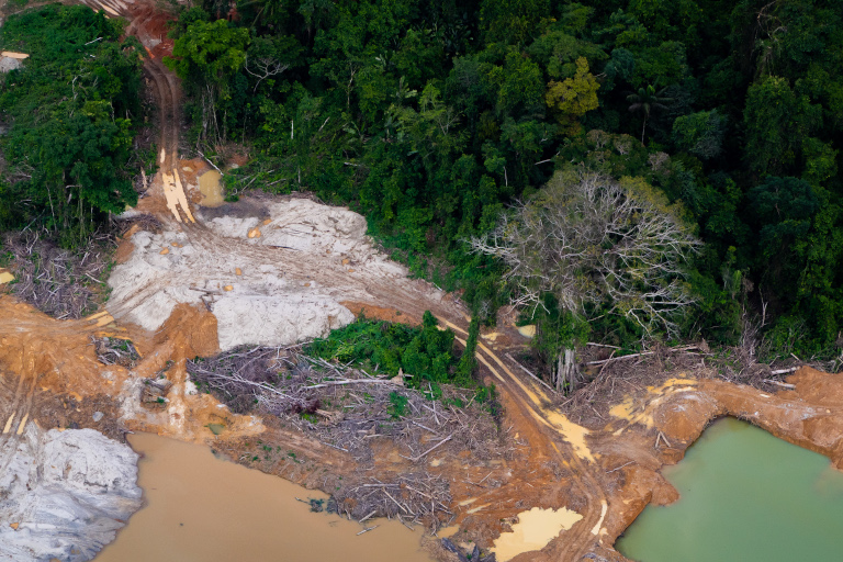
Almost 19% of the Amazon is made up of paved or unpaved roads, according to the study, causing a “series of disturbances” including habitat fragmentation, sound and chemical pollution and higher animal mortality from road accidents.
The biggest problem, however, is that they “are becoming increasingly relevant in the loss of Amazonian Forest since they are entry points for other pressures on the territories,” the report stated. Unofficial secondary roads fan out deep into the forest from the main highways, creating routes to new spaces for cattle ranching, mining and land-grabbing.

In Brazil, deforestation in the northwest of the country’s Amazon — “the most intact portion of the Amazon Rainforest,” according to the study — is being worsened by the proposal to pave the muddy BR-319 highway that cuts through the rainforest to connect Porto Velho, the capital of the state of Rondônia, and Manaus, the capital of the state of Amazonas. Currently, part of the dirt road is impassable during the rainy season but paving it will make it accessible all year round.
“The highway affects several Indigenous territories,” Aurélio Tenharim, an Indigenous leader in the south of Amazonas state, told Mongabay by phone. “It will bring in invasions of illegal logging, fishing and hunting. Invasions already exist here by heavily armed people.”
Deforestation from agriculture
Agriculture expansion was responsible for 77% of the deforestation in the Amazon from 2001-20, converting 416,103 km2 (160,658 mi2) patches of rainforest into pastures. The Brazilian Amazon biome lost the highest portion, with 307,163 km2 (118,596 mi2) deforested. Brazil, Bolivia and Colombia all show rising trajectories of rainforest-to-agricultural use conversion.
In Bolivia, the Chiquitania region has seen a 352% increase in deforestation from 2001-20 after new regional road development and a population boom increased agricultural activity, especially in cattle and soy. The regional effects are already being felt — deforested areas are up to 9 degrees Celsius (16.2 degrees Fahrenheit) warmer than before and annual precipitation has reduced by 17%, leading to severe droughts, according to InfoAmazonia.
“Unfortunately, Bolivia has stopped looking at forests as the source of economic production that it was years ago,” Quintanilla said. “This is an important factor in the rise of deforestation there.”
Extractive activities
Mining affects 17% of the Amazon and overlaps with 11% of Indigenous territories, causing devastating consequences, such as the Yanomami Indigenous community in Brazil who have been exposed to violence and disease after decades of invasions and illegal gold mining in the territory.
Oil blocks occupy 9.4% of the Amazon, 43% of which are within ITs and PNAs. Most of them (369) are found in Bolivia, Colombia, Peru and Ecuador, where numerous Indigenous live, including isolated communities. In the last 20 years, Peru registered 500 oil spills, whereas Ecuador recorded 899 between 2015 and mid-2021.
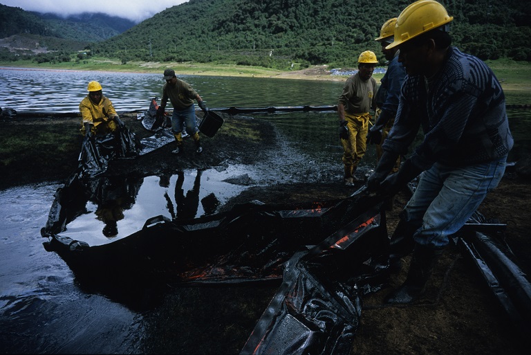
“The impact of oil spills on the environment is devastating, especially those of large volumes,” Cáceres said. “The Indigenous population that depends on the resources provided by the surrounding environment are seriously affected by hydrocarbon spills.”
Finding solutions
Moving to an optimistic trajectory of deforestation requires establishing sustainable development plans, effectively managing protected areas, implementing efficient public policies and strengthening control and monitoring, according to the study.
However, conservation solutions often clash with economic interests.
“Governments are always attempting to weaken legislation or to sign off on development projects that will have terrible impact,” Watson said. Current examples include Peru’s Congress debating a new bill that would open Indigenous territories to oil and gas drilling and “would devastate the country’s uncontacted tribes” if approved, according to a statement from Survival International.
“We are accelerating the elimination of forests and we’re getting closer to a tipping point in the Amazon,” Quintanilla warned. “The Amazon looks vulnerable and fragile as it loses its forest.”
Banner image: The Yanomami Indigenous Territory in the Brazilian state of Roraima has faced invasions by illegal miners for decades. These invasions have led to a severe health crisis among the communities that live there as well as high levels of deforestation. Image by Christian Braga/Greenpeace.
Relevant reading
Amazon deforestation on pace to roughly match last year’s rate of loss
2021 Amazon deforestation map shows devastating impact of ranching, agriculture
FEEDBACK: Use this form to send a message to the author of this post. If you want to post a public comment, you can do that at the bottom of the page.