- How does public land in the Brazilian Amazon, including chunks of protected areas and Indigenous territories, end up under private ownership?
- This investigation unveils the network of realtors and engineers who take advantage of Brazil’s disjointed land registration system to launder stolen land.
- Experts say the CAR land registry in particular, which was meant to prevent environmental crimes, has instead made land grabbing easier than ever.
- This article was originally published in Portuguese by The Intercept Brasil and is part of the Ladrões de Floresta (Forest Thieves) project, which investigates the appropriation of public land inside the Amazon and is funded by the Pulitzer Center’s Rainforest Investigations Network.
NOVO PROGRESSO, Brazil — It’s Aug. 15, 2022, a public holiday in Brazil’s Pará state, and the day has just begun in the southern municipality of Novo Progresso. But this town of 25,000, located by the BR-163 federal highway, isn’t in a holiday lull. While the first wave of customers arrives at the gold stores, half a dozen men try to recover from a busy night in the red-light district, ahead of another day of work burning, mining or clearing land. At their offices, realtors and chartered engineers file the paperwork to round out this grab of public land.
Novo Progresso is Brazil’s “agribusiness–mining hub,” where “every inch is disputed by investors,” boasts one of several Facebook profiles selling rural plots of land. Clients have a varied menu to choose from: land with or without forests, inside or outside conservation areas, subjected to environmental sanctions or not, with or without gold in the ground. The catch? Title deeds aren’t included.
“Documented farms are very rare in this area,” says Roberto (not his real name), one of several realtors profiting from rising land prices in southwestern Pará after BR-163 was fully paved in late 2019.
With so much demand, those asleep at the wheel risk losing business. “There are few options left, eh? Especially if you’re looking for land to plant,” Roberto says, referring to soy, the crop of choice in this part of Brazil. “Things around here are such that after three or four days, the owner is already selling.”
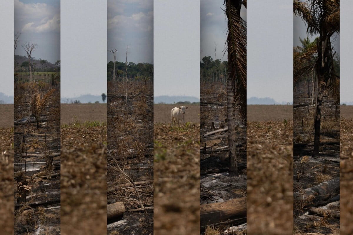
The real estate boom is riding a new wave of land grabbing and deforestation, targeting mainly undesignated public lands — government-owned areas, federal or state, that aren’t classified as conservation units, Indigenous territories, agrarian reform settlements, forest concessions or private property.
According to a Greenpeace report, deforestation in undesignated land around BR-163 in Pará increased by 205% between August 2019 and July 2020, compared to the previous 12-month period.

As we reported in the first article of the “Forest Thieves” series, which told the story of the single-largest instance of deforestation ever recorded in the Brazilian Amazon, land grabbing isn’t an amateur enterprise. Instead, it’s an organized crime effort that demands multimillion-dollar investments and the participation of a wide network of perpetrators. In the land-grabbing pecking order, the grunts are the workers who go deep into the forest to cut it down, often working under slavery-like conditions. At the top of the heap sit the individuals who bankroll the deforestation and profit from the stolen land, either by selling it to third parties or by exploiting it with farming.
In between the two lies an ecosystem of middlemen, who usually go unnoticed but earn significant amounts of money from the land grabs. Impersonating a farmer interested in buying land, I reached out via the messaging app WhatsApp to two realtors who work in areas close to the federal highway. At the end of the investigation, when I revealed my true identity, one of the men said he could be killed if his name were mentioned in the article. For this reason, and given the region’s history of gun violence and assassins for hire, both men are referred to by pseudonyms.
Five minutes after I send him my first message, Roberto is ready to look for areas in which I might be interested. Within a few days, he sends me four farm options. One of them is a 3,000-hectare (7,500-acre) lot in the Castelo dos Sonhos district for 135 million reais ($26.7 million). Nearly three-quarters of the land had been cleared and turned into pasture. Its main selling point is its topography: a flat area, good for agricultural machinery and, therefore, for soybean farming. “It’s all plain; you look at an image and you see everything,” Roberto says.

Another plot, in Novo Progresso, is going for 35 million reais ($6.9 million), although it’s bigger, at 1,936 hectares (4,784 acres), almost 90% of which had been deforested. Under Brazilian law, landowners in the Amazon are only permitted to clear up to 20% of their plots, leaving the rest, known as the legal reserve, intact. The listing actually notes that the plot is the subject of a fine and embargo by environmental authorities — not really a deal breaker in a region where sanctioned lands are very common and yet still sell. This particular plot includes a brick main house, an internet tower and even a runway for a single-engine plane.
The listing is rounded out with the ultimate pitch: “The area has gold.” In our reporting, we found that landowners in the area often allow miners onto their plots in exchange for a percentage of the metal illegally extracted.

The power of the gun
My chat with Roberto ends when he says he’ll only send me the location of the farms if I sign with him exclusively. Under such contracts, customers undertake not to buy properties “through other intermediaries or directly from owners.” If they do, they incur a penalty, owed to realtors like Roberto, of 6% of the property’s value.
Meanwhile, I’ve also contacted a second realtor, Gustavo, who soon asks the usual questions to establish my customer profile: the size of the land I want, how I intend to use it, what my budget is, and how picky I am about getting all the proper documents. It’s clear that if I want a plot of land with all the necessary paperwork in place, I should look further north, near the municipality of Santarém.
I tell Gustavo that I’m in the market for about 6,000 hectares (14,800 acres) for ranching cattle or maybe even growing soy. “Wonderful! That’s a lot of land. I’m going to look into the options for that size,” he replies
I also tell him that I’d be fine with just a registration in the Rural Environmental Registry (CAR) and the area’s georeferenced data — that is, a plan based on the farm’s geographical coordinates and boundaries.
Over the course of two months of conversation, Gustavo offers me eight listings near BR-163, in a region covering Castelo dos Sonhos, Novo Progresso, Trairão and Altamira. Prices range from 25 million to 100 million reais ($5 million to $19.8 million). If a sale were to happen, Gustavo’s commission would be 3%, or from 750,000 to 3 million reais ($149,000 to $595,000). “It’s usually 5%, but if the area exceeds 10 million [reais, or $2 million], we can do 3%,” he says.
The most expensive of the listings is near the banks of the Jamanxim River, with four houses, a corral, a shed, electricity and internet connections, and enough land for 8,000 head of cattle. Almost half of the area located between Castelo dos Sonhos and Novo Progresso, some 2,400 hectares (5,900 acres), is already “formed,” which in land-grabbing parlance means the forest has been cut down and grass has been planted. All this is on offer for 100 million reais ($19.8 million).
Another listing, for 80 million reais ($16 million) has more than a third of its 6,444 hectares (15,823 acres) “outside the reserve.” That’s the local way of referring to Jamanxim National Forest, Brazil’s second-most-deforested conservation unit, according to INPE, the national space research agency. The farm is very well equipped: two houses, employees’ quarters, cafeteria, shed, a “sheep house,” large corral, electricity and internet, and “excellent access road.”

We visit one of Gustavo’s listings, a 35 million reais farm spread across 4,157 hectares (10,272 acres) — 72% of it deforested — and located in an undesignated federal area known as Curuá. Getting there starts with a 50-kilometer (30-mile) drive north from Novo Progresso along the federal highway, then onto a dirt road called Diamantino. After another 60 km (37 mi), passing by cattle farms and other areas still smoldering from recent fires, we arrive at the advertised farm: a large expanse of pastures with a few head of cattle, surrounded by vast soybean plantations. (During our visit in August, the land was being prepared for planting).
“There are a lot of rich people in the area. If you have firepower, you have the business,” Gustavo says via WhatsApp. The “firepower” is both figurative and literal: it refers to both the economic clout of the landowners here and their arsenal of weapons to intimidate neighbors and “solve” any conflicts that may arise.


Those without all that “firepower,” however, can still buy land with standing forest for 10,000 reais ($2,000) per hectare. “But we’ll try to get you a better price,” Gustavo says. Eager to close the deal, he refers me to a local man who works felling trees. “It’s not hard to find people to clear land around here. We are working on it.”
In a statement to us, the Regional Council of Realtors in Pará, CRECI-PA, says facilitating sales of land without regular titles is a breach of the council’s code of ethics, with penalties ranging from verbal warnings to license cancellation. Gustavo’s case, if he were caught, would be even more serious. Unlike Roberto, he’s not accredited by the council, so his sales activity constitutes a misdemeanor criminal offense. Gustavo himself admits to using a fake CRECI registration.
The land-grabbing engineer
None of the listings offered by Gustavo and Roberto around BR-163, nor many of the others found online, specify whether the plots come with title deeds. But there are plenty of references to CAR registrations — a document created in 2012, along with the new Forest Code, as a check against environmental destruction.
In land grabbers’ hands, however, CAR registrations have become a legal veneer to be applied when taking over public areas. A report approved in November by the Senate’s environment committee identified more than 14 million hectares (35 million acres) of public land illegally registered on the CAR system as private properties by the end of 2020. Of these, 3.4 million hectares (8.4 million) had already been deforested. “The link between CAR-based land grabbing and forests removed as a means of proving land ownership … is one of the main drivers of deforestation,” the committee said.
CAR registrations are mandatory for all rural properties. On the registry, applicants must put down their names and taxpayer numbers, the location of the plots, and which parts are designated for permanent preservation, legal reserve, farming, etc.
But because the system is self-declaratory, anyone can register property on the CAR wherever they want, whether or not they actually own the land. Under the law, applicants must prove “rural ownership or possession,” but don’t have to present land titles or other proof of registration. In theory, all the information that goes into the CAR system must be verified by officials from state or municipal environmental departments, who should also ensure that the property doesn’t overlap with Indigenous lands or conservation areas. In practice, however, only 1% of CAR registrations in the Brazilian Amazon have undergone verification, resulting in a free-for-all in protected areas.
“Land grabbing has never been so easy, thanks to the CAR, which is a terrible land-grabbing instrument,” says Maurício Torres, a professor at the Federal University of Pará (UFPA).
Each CAR application is entered into the federal government website or each state’s system. In Pará, for plots larger than 300 hectares (740 acres), registration requires a georeferenced plan of the area — a map, essentially.
This is where another part of the land-grabbing service industry comes in: the engineers. These are professionals trained in georeferencing who are willing to put their knowledge to use for land grabs of public areas, for a fee.
The engineers’ main jobs — as revealed from law enforcement operations in Amazonas state and Pará state – include registering farms located on public land to individuals serving merely as figureheads to conceal the true “owners”.
“We noticed that there is a market of specialized services,” says Rafael Rocha, from the Amazonas federal prosecutors’ office, who worked on the operation in that state. “For example, the farmer already has a geoprocessing consultant who tells him, ‘Look, you can occupy this area, register it to a figurehead and then regularize it.’”
Once again, undesignated lands are the main target of this consulting work. “They pick the areas very carefully, focusing on undesignated land, because they don’t want to waste money by invading private property or a protected area,” Rocha says.
In the BR-163 area, few engineers have as large a clientele as Bianor Emílio Dal Magro, from Novo Progresso. A search of his taxpayer number on the CAR system in Pará yields 35 consecutive pages of properties that he has registered on the system.
Official data accessed in late May 2022 show that Dal Magro, an agronomist by training, was responsible for registering 530 CARs in the region. Of these, 70% overlapped with undesignated public land and 20% with protected areas, mostly Jamanxim National Forest.
Born in Santa Catarina state, Dal Magro is 69 years old and works at Guará Agroserviços, a company managed by his son, Júlio Cesar Dal Magro. Júlio da Guará, as he’s known, was arrested on suspicion of murdering Aluisio “Alenquer” Sampaio, president of the regional chapter of the Union of Family Farm Workers, in October 2018.
Posing as a landowner, we contact a Guará employee and ask how much it would cost to georeference and file a CAR registration for a plot of just over 1,000 hectares (2,500 acres) located between Castelo dos Sonhos and Novo Progresso. The employee says it would cost 11,500 reais ($2,300) for the CAR and georeferencing and 14,500 reais ($2,900) if we also wanted to register the property on SIGEF, the land governance system managed by INCRA, the federal agency for land reform.

Dal Magro’s clients include Delmir José Alba, a.k.a. Nego Alba. According to environmental authorities, he and Jeferson Rodrigues were key players in the massive deforestation and land grab scheme covered in the first article of this series, and the Piovesan Cordeiro family — large landowners who’ve been sanctioned many times for environmental violations inside Jamanxim National Forest, according to a report by Agência Pública.
In October 2021, Dal Magro and the Piovesans were targeted by SOS Jamanxim, a Federal Police operation against a criminal organization that deforested 15,000 hectares (37,000 acres) inside the conservation unit. Dal Magro, whose office was raided by investigators, was in charge of registering illegal properties on the CAR system, several of them to figurehead “owners”. The Federal Police declined to comment on the case, saying it’s being heard in private.
Torres says Dal Magro is much more than a service provider for local land grabbers. “He has a very good database, and he knows what’s going on out there. He’s more than a designer.”
CAR jigsaw puzzles
Thanks to his knowledge of georeferencing and the region in which he operates, Dal Magro has been able to manipulate the system to meet his clients’ needs. And their needs are varied. In 2016, for example, one client wanted 67,500 reais ($13,400) in funding from the government’s National Program to Strengthen Family Farming (Pronaf). The money was ostensibly for buying 110 breeding cows and three breeding bulls for a property belonging to the family.
But there was no property, and the money would never be used to buy any animals. This didn’t prevent Dal Magro from making up a farm plan and registering it on the CAR to a figurehead so that Banco da Amazônia would issue the loan. He “used fraudulent means, which harmed the federal public interest,” according to charges filed that same year by the federal prosecutors. As of April 2023, the case still hadn’t gone to trial.
The services of professionals like Dal Magro are also very useful for cattle ranchers who have illegally deforested their properties and need to find a way to circumvent the sustainability demands of meatpacking companies. Many of these companies are signatories to the Meat Industry Conduct Adjustment Agreement (TAC) with federal prosecutors, in which they commit not to source beef from farms where there has been illegal deforestation and/or slavery-like labor.
For farms that fit that bill, one way to get around the ban is to split the CAR registration — that is, to register two parts of the same property separately, one next to the other.
“Sometimes the same farm is divided into two CAR registrations — one with deforestation and the other without it,” says Raoni Rajão, a professor of environmental management at the Federal University of Minas Gerais (UFMG) and a researcher at the Washington, D.C.-based Wilson Center. “When it’s time to sell the cattle, the rancher says that the animal came from the area without deforestation, when in fact it’s all the same farm. That has been happening very often.”
Such a strategy is clear in one of the listings offered to us by Gustavo: a 4,900-hectare (12,000-acre) plot that’s subject to environmental fines, but with “its own georeferenced data.”
Title in sight
Dividing a property violates the normative instruction governing the CAR registration. Even so, properties are often divided and registered to figureheads by people trying to circumvent the land regularization law. That law allows titling areas of up to 2,500 hectares (6.200 acres) and only to people who don’t own other properties. Furthermore, the smaller the property, the faster and cheaper it is to get a title for it. Plots up to 300 hectares don’t require prior inspection by INCRA, while those of 75 hectares (185 acres) or smaller receive free titles.
This strategy is clear in one of the listings sent by Gustavo: an elaborate video including professional images captured by a drone, with a soundtrack that seems to have been taken from an adventure film. The images show a vast 5,000-hectare (12,400-acre) farm crossed by three streams, with a two-story, three-bedroom house, two corrals, three cowboy houses, and a dam with a water wheel. Among its features, the realtor points out that “the area is awaiting two titles of 2,225 hectares,” or 5,500 acres, each.
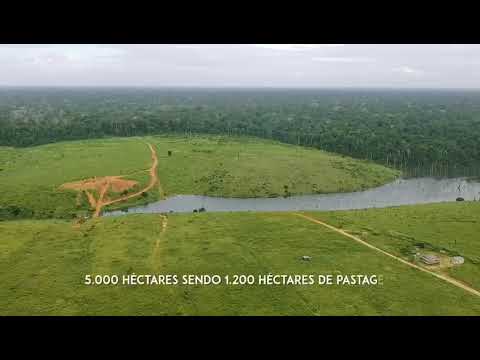
Video of farm offered for sale by Gustavo. The listing says “the area is awaiting two 2,225-hectare titles.” Video courtesy of Gustavo.
Once again, this is where the services of specialists like Dal Magro come in handy. They can carve up a large estate that doesn’t meet title rules into several smaller properties that do.
Dal Magro did just this for the Terra Nossa Sustainable Development Project in Novo Progresso. This is a land reform project on which he’s worked since the first lots were demarcated in 2006. He even registered an area to himself. The settlement, in an area separated in 2003 from the Baú Indigenous Territory due to pressure from farmers, has become the scene of numerous land conflicts. In 2018 alone, there were at least three killings: in addition to Alenquer, brothers Romar and Ricardo Roglin were killed. Antônio Rodrigues dos Santos, known as “Bigode,” went missing that same year and is presumed dead; his body has never been found.
The case involving Dal Magro centers on the Coringa Farm, a 6,700-hectare (16,600-acre) area occupied largely by businessman Benedito Gonçalves Neto and the subject of mining interest from the company Chapleau Exploração Mineral. According to federal experts who were there in 2007, Dal Magro divided the property into several CARs, which were registered to figureheads, and then applied to INCRA to start the regularization process.
At about the same time, Dal Magro used the same technique on another property partially overlapping the Terra Nossa settlement. This time, a 21,860-hectare (54,020-acre) area occupied by another businessman, Bruno Heller, was divided into smaller properties registered to several of Heller’s relatives. We were able to identify 10 contiguous areas registered to Heller family members on Pará’s CAR database: nine of these had been registered by Bianor Dal Magro.
“We established a connection between Guará Agroserviços and land grabbing in the region,” INCRA wrote in an assessment of the settlement published in 2018, which recommended that the agency’s regional director “cancel the company’s license to provide topographic services.” In a follow-up statement, INCRA said the recommendation could not be carried out because only individuals, and not companies, are accredited to provide georeferencing services. Yet Dal Magro’s accreditation was never canceled.
In addition to CAR registrations, land grabbers submit other documents that are equally null from a legal point of view, in order to convince potential buyers of the legality of the areas for sale. “GEO, CAR and Term of Possession,” one listing reads. “CAR, GEO, ITR,” another one says. Like a CAR registration, the ITR, Brazil’s rural property tax, is also based on self-reporting. “If I want to pay ITR over the Tapajós River, the Federal Revenue Service will accept it,” says Torres, the UFPA professor.
In practice, what land grabbers do is take advantage of the tools of the state to legitimize their land grabs. “It’s the same as breaking into an apartment and notifying the government: ‘Look, I’m a trespasser but I’m going to pay property tax,’” says Paulo Barreto, a senior researcher at Amazonian conservation NGO Imazon. “Just like registering on the CAR, paying rural property tax is a way of demonstrating that the land was occupied in good faith.”

Land grabbers expect to be awarded with a land title at the end of this process. “You take something absolutely illegal, which is land theft, and then you throw legal social connections on top of that illegality. Then there comes a time when you have so much legal stuff linked to this illegality that the whole scheme is pardoned,” Torres says.
We sought comment from Dal Magro through his lawyer and daughter, Rafaele Dal Magro, but he declined to comment. Despite Dal Magro’s history of fraud, no administrative proceedings have been brought against him by CREA, the Regional Council of Engineering and Agronomy, which is supposed to oversee the work of chartered professionals in these fields.
The CREA in Santa Catarina state, from where Dal Magro has his main professional accreditation, said that “if there is an ethical complaint against the professional, appropriate legal measures will be taken,” but didn’t detail what these measures could be. The CREA in Pará, where he works, said professionals who violate the code of ethics “may receive a private reprimand, public condemnation, suspension, cancellation of registration, and fine.”
CONFEA, the Federal Council of Engineering and Agronomy, said only that professionals’ ethical conduct is regulated by the code of ethics.
INCRA, the land reform agency, issued a reprimand to Dal Magro for using its Land Management System to register a farm overlapping with Iriri State Forest, in Pará. In an email, the agency told us that it doesn’t investigate possible irregularities in public registrations of other agencies such as the CAR.
The Brazilian Forest Service, in charge of implementing the CAR at the federal level, said its system no longer allows registration of properties overlapping with Indigenous territories and that it intends to check any overlaps with other federal lands.
Semas, the Pará state environmental protection agency, said it can’t automatically block properties overlapping with public lands, as its CAR registration system is linked to that of the federal government.
This article was originally published in Portuguese by The Intercept Brasil and is part of the Ladrões de Floresta (Forest Thieves) project, which investigates the appropriation of public land inside the Amazon and is funded by the Pulitzer Center’s Rainforest Investigations Network.
The $20m flip: The story of the largest land grab in the Brazilian Amazon
FEEDBACK: Use this form to send a message to the author of this post. If you want to post a public comment, you can do that at the bottom of the page.