- Surveying and collecting rare plant species that grow on steep cliffs has been a risky affair for scientists and conservationists for hundreds of years.
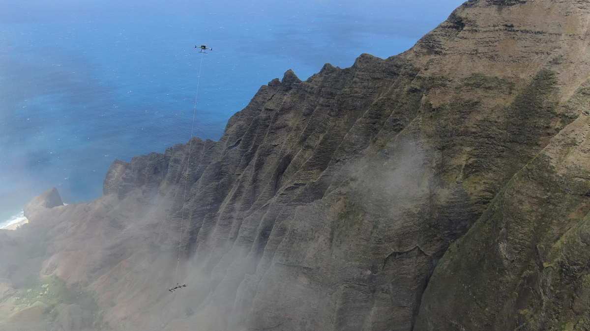
- The world’s first aerial sampling system that comprises a robotic arm suspended from a drone is trying to solve the problem in Hawai‘i.
- Conservationists control the Mamba robotic arm via remote control to identify and cut samples from rare plant species.
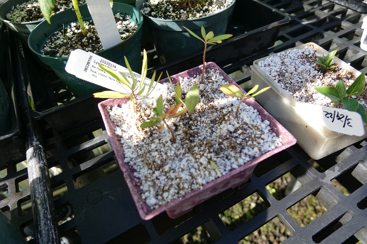
- The tool has enabled scientists to collect endangered species from vertical terrain and grow them in nurseries.
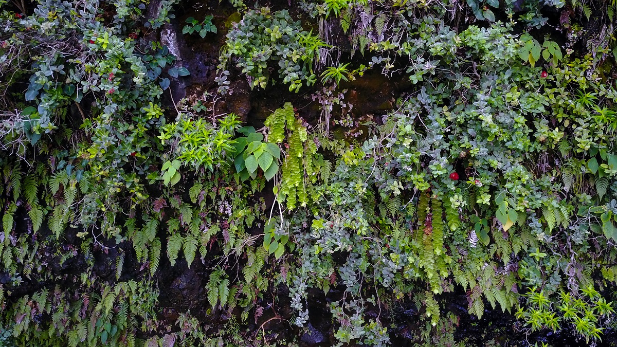
For far too long, studying plant species endemic to high-altitude cliffs was no small feat. More often than not, it involved researchers abseiling down cliffs to survey rare species and collect samples to take back to their labs. Drones made observing and documenting plants in rough terrain easier, but didn’t solve the difficulty of retrieving rare species for propagation or research. Now, a new tool that combines drones and robotics aims to solve that problem with cutting-edge technology.
In Hawai‘i’s Kaua‘i island, the world’s first aerial sampling system has successfully flown into high-altitude cliff faces to cut out samples from rare plants and bring them back to a nursery. Scientists call it “the Mamba,” a cutting mechanism on a remote-controlled robotic arm suspended from a drone. The system was developed by Hawai‘i-based not-for-profit conservation organization National Tropical Botanical Garden (NTBG) and Quebec-based technology company Outreach Robotics and the University of Sherbrooke in Quebec.
“It is really unlocking a lot of areas that have previously been completely inaccessible,” Ben Nyberg, the NTBG’s geographic information system and drone program coordinator, told Mongabay in an interview.

The tool has the potential to reshape plant conservation efforts in Kaua‘i where, until now, conservationists and researchers were forced to take huge risks to access these plant populations. The need to save species on the island is urgent. According to a 2022 study in Scientific Reports, by the same team that developed the Mamba, 97% of the 250 plant species endemic to Kaua‘i are considered endangered, critically endangered or extinct.
Mongabay spoke with Ben Nyberg about the Mamba’s impact, the tool’s future applications, and the challenges ahead.
Mongabay: How would you explain the Mamba to someone who doesn’t know about it?
Ben Nyberg: I would start by explaining the challenge that we are facing with plant rarity and extinction in Kaua‘i, highlighting the number of rare species that are growing on cliff faces and how difficult they are to access. We do have collectors that go down ropes, but that is limited to the rope length. And there is a large section of Kaua‘i that’s not accessible by rope. So that sets up the issue of why we are thinking about ways to get to these plants that are not accessible on foot.
This tool focuses on plant conservation work with the aid of drones and robotics. The mechanism revolves around an aerial robotic sampler with a cutting mechanism that is suspended from a drone. Once it gets around the plant, it can grasp it and cut the stem and then bring it back to a distance of 1,500 meters [nearly a mile] away.

The Mamba sampling tool collecting samples off a cliff at Honopu Ridge. Credit: Outreach Robotics.
Mongabay: How did this come together?
Ben Nyberg: We started doing drone surveys in 2016, and were applying that around Kaua‘i and having great success finding rare plant populations. Pretty quickly, we started having nice, big discoveries and found plants that were thought to be extinct.
I was then approached by a group in Quebec that was working on drone cutting tools. The tool that they had at that point was for sampling from the top of a tree. So, it had a carrying drone, and then a long line, and it would just drop into the tops of trees. They asked if I would want to work together on sampling from vertical surfaces. In 2019, we put in a funding application to National Geographic.
Mongabay: What was the journey like after you received the funding?
Ben Nyberg: We didn’t really know exactly what the design was going to look like at that point. We were looking at potentially an extendable pole that went out and could do the picking. We were planning to come out to do our first field trip in 2020, but COVID-19 hit.
So that gave them an additional year and a half in the robotics lab in Quebec. They were testing all these different designs and we had a lot of meetings to talk about the potential plant targets and what the specific requirement of the cutting mechanism would be. It actually was a blessing in disguise — having that extra time — because we got to work out a lot of things in the lab and really refine the design.
When we did the first field trial in October 2021, it was very successful. There were no crashes, and we were able to collect from our target species. And then in March 2022, we did our second trial. We built upon the success of the first trip and moved up in difficulty, both in terms of terrain and target species.
Mongabay: Could you describe some specific applications in terms of what you found in the test flights?
Ben Nyberg: Five critically endangered species were collected from inaccessible locations in the first trip. The second trip is really where a lot more of the conservation action happened because we were working on high-value targets. One that I like to highlight is this species Lysimachia iniki that grows in the Blue Hole region of Kaua‘i, which is one of the wettest places on Earth. Until now, we have just managed to collect seeds from pieces that have broken off and fallen to the bottom of the cliff because they grow on such inaccessible terrain. Now we are able to go in and intentionally collect them.
Using a spotting scope, we can look up and see the specific individual that we want to collect from — ones that have seeds and flowers on them. So, we are now getting a beautiful collection with lots of seeds on them.
There’s another rare plant species, Plantago princeps, that is in the plantain family. We found a large population with a drone in the early days of our drone survey process. And for many years, we didn’t know how we were ever going to get there. We thought, “Great, we know they are there, but there is nothing we can really do about it.” And now, we were able to collect it during the second flight.
Mongabay: What do you do once you have collected the samples?
Ben Nyberg: All the samples we collected are successfully growing in our nursery with flowers. We have also been very successful in getting these to root and grow from cuttings. We are also getting a lot of seeds for storage and for growing these rare and endangered species. So, the drone has been a crucial conservation tool for these species and is really opening the door to exploration of cliff habitats.
Mongabay: Working at such high altitudes isn’t easy. Could you walk me through some of the challenges that you face with the use of the tool?
Ben Nyberg: There is always going to be a challenge with wind and weather. That’s a given with drones. We can try and incrementally get a little better at working in these different situations. But you don’t want to make it harder for yourself. So, you just need to pick the best day.
One thing that we really have been trying to figure out is GPS. A lot of the areas are ravines or rock alcoves that are protected, and once you go in there with a drone, your satellite positioning drops out. And it becomes very difficult to work precisely without that stabilization that satellite location provides. So, we are now looking at potentially adding more GPS receivers to work with additional satellite constellations.
The other challenge is getting the head that we have designed to do exactly what we needed to do. We tried to design a one-size-fits-all, but we are realizing that maybe there are specialized cases that need something different. So, our main focus now is to just rework a little and see if we can have different sampling heads that do different tasks.
Mongabay: Where is the Mamba headed from here? Any plans to commercialize soon?
Ben Nyberg: We put in an application for a second round of funding from National Geographic and it was accepted. So, the next move is to continue development.
Commercializing it is still up in the air. Right now, it is in the prototype phase. It requires some specialized experience to set up and deploy. I think it is possible in the future that it would be on the market as a tool you could buy, but it is just going to take a little more refining and finalizing the design. We have talked about also just offering it as a service. Someone might not want to buy a whole unit and the bigger drone, because it is quite a bit of outlay of cash in the beginning. So, they could actually bring the team out to do a project or something on those lines.
Mongabay: Do you see any applications for this tool outside of plant conservation?
Ben Nyberg: I think that this new tool can be applied in a lot of different ways. One thing that we have thought about a lot is data loggers. If you could stick a data logger onto a cliff, and then be able to go back and pick it up later on, I think it can be really powerful, because that’s an area that a lot of scientists have a hard time accessing. Anybody working in difficult vertical terrain, I would think, could find some way to apply this type of technology.
Mongabay: Drones were being used widely at one point in time in conservation, but now the hype seems to have subsided a little. Would you agree?
Ben Nyberg: People were like, “Drones can solve every problem.” I don’t think that they can. But I think as people learn the limits and the scale that drones will work on, that’s when it can be applied better.
I think that there are a lot of situations where maybe a drone isn’t the best tool: where, for example, using satellite imagery may be better. But there are a lot of ways that they are very useful and give you just a different viewpoint into what you are looking at. And vertical terrain is definitely one of those areas where drones tend to be a great tool.
In large-scale conservation projects, drones may not be the answer for everything. But for conservation of more targeted, individual species, it is a good tool. But I agree, we certainly went over the hump of everyone being excited. Now it will be more of a slow build back to finding ways to apply drones that makes sense to those projects.
Mongabay: Finally, how do you think conservation technology is faring at the moment? What more needs to be done?
Ben Nyberg: It is inspiring to see big conservation technology projects going on. I am especially excited by AI. I think there are probably ways that it can be applied in my work that I haven’t explored yet. So, there is definitely a lot going on.
Ben Nyberg: It is inspiring to see big conservation technology projects going on. I am especially excited by AI. I think there are probably ways that it can be applied in my work that I haven’t explored yet. So, there is definitely a lot going on.
Citation:
La Vigne, H., Charron, G., Rachiele-Tremblay, J., Rancourt, D., Nyberg, B., Lussier Desbiens, A. (2022). Collecting critically endangered cliff plants using a drone-based sampling manipulator. Scientific Reports, 12, 14827. doi: