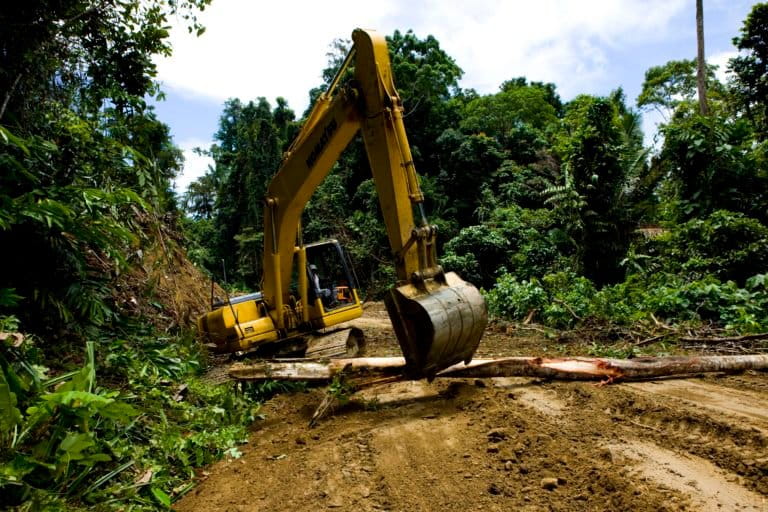
- Set to run some 4,000 kilometers (2,500 miles) and being built over the course of decades, the Trans-Papua Highway cuts across the entire length of Indonesian New Guinea’s two provinces.
- While nearly complete, it has not yet fully interlinked major cities, and has raised concerns among experts that it could open up the world’s third-largest swath of tropical rainforest to further deforestation. Tanah Papua has already lost 750,000 hectares of forest cover (1.85 million acres) over the past 20 years.
- A study published last September warns that if the Trans-Papua Highway spurs a similar spate of development on Papua as the Trans-Kalimantan Highway did on Borneo, the region could lose up to an additional 4.5 million hectares (11.12 million acres) of forest cover by 2036.
- For this episode of the Mongabay Explores podcast, we interview David Gaveau, who founded The TreeMap (a forest loss monitoring platform), and distinguished professor at James Cook University, Bill Laurance to discuss the impacts the Trans-Papua Highway could have for Indonesian New Guinea.
The fourth episode in the New Guinea series of Mongabay Explores uncovers the massive Trans-Papua Highway, the potential it has to deforest the largest protected area in Southeast Asia, and potential pathways forward for conservation. Listen here:
This week we interviewed David Gaveau, founder of The TreeMap. Gaveau was an author of a study published in September detailing the potential of forest loss that the Trans-Papua Highway could inflict on New Guinea.
We also spoke with Bill Laurance, distinguished professor and director of the Center for Tropical, Environmental and Sustainability Science at James Cook University in Australia. Laurance explained the environmental, financial and social costs of the project, which runs through Indonesia’s Lorentz National Park, a UNESCO World Heritage Site.
Gaveau and his team at The TreeMap found positive correlations between the expansion of the Trans-Papua Highway and the expansion of oil palm plantations during the peak building phases of the road. While deforestation related to oil palm has declined for four consecutive years, both Gaveau and Laurance worry that’s about to change. Gaveau emphasized the urgent need for the central government to recognize Indigenous territories and center any development around the needs and desires of Indonesian New Guinea’s local inhabitants, as outlined in the 2018 Manokwari Declaration signed by the governments of Papua and West Papua provinces.
Mongabay Explores is an ongoing episodic podcast series about the world’s unique places and species. Each season dives into new areas of amazing natural heritage to environmental challenges and conservation solutions. This season, it’s exploring the great conservation and cultural richness of New Guinea. If you missed the first three episodes in this season, you can listen to them here.
If you want to hear our previous episode on the birds-of-paradise, and the potential for ecotourism to provide economic development to Papua’s original inhabitants listen here:
Related Reading:
- Plantations and roads strip away Papua’s forests. They’re just getting started
- Indonesia is clearing less forest for palm oil, but it’s still not sustainable, activists say
- 2019 fires in Indonesia were twice as bad as the government claimed, study shows
If you enjoy Mongabay’s podcasts, we ask that you please consider becoming a monthly sponsor via our Patreon page, at patreon.com/mongabay. Just a dollar or more per month helps us offset production costs and hosting fees, and can help us create special series like Mongabay Explores.
Subscribe to Mongabay Explores on Spotify, Apple, Google, or wherever you get podcasts. Listen to all of the Mongabay Explores podcast episodes via the Mongabay website here.
Sounds heard during the intro and outro include the following: rusty mouse-warbler, growling riflebird, raggiana/lesser bird-of-paradise, superb fruit-dove, long-billed honeyeater, little shrike-thrush, brown cuckoo-dove, black-capped lory. Special thanks to Tim Boucher and Bruce Beehler for identifying them.
Soundscape credit: recorded in the Adelbert Mountains in Papua New Guinea by the communities of Musiamunat, Yavera and Iwarame in partnership with The Nature Conservancy and Zuzana Burivalova/Sound Forest Lab.
Banner Image: A part of the Trans Papua highway that snakes across Indonesia’s easternmost provinces Papua and West Papua. Photo courtesy of Public Works and Housing Ministry.
Editor’s Note: Bill Laurance, is a Distinguished Research Professor at James Cook University in Cairns, Australia as well as the founder and director of ALERT (Alliance of Leading Environmental Researchers & Thinkers) and a member of Mongabay’s advisory board.
Mike DiGirolamo is Mongabay’s audience engagement associate. Find him on Twitter @MikeDiGirolamo, Instagram, or TikTok via @midigirolamo.
Citation:
Gaveau, D. L. A., Santos, L., Locatelli, B., Salim, M. A., Husnayaen, H., Meijaard, E., … Sheil, D. (2021). Forest loss in Indonesian New Guinea (2001–2019): Trends, drivers and outlook. Biological Conservation, 261, 109225. doi:10.1016/j.biocon.2021.109225