
- In recent years, a number of sinkholes have emerged in Baringo county, a geologically active region in western Kenya’s Great Rift Valley.
- According to geologists, their appearance can be linked both to the worsening impacts of climate change through floods and droughts, and local communities drilling boreholes along precarious fault lines to access more water.
- According to members of the community, the sinkholes have yet to spur the county or the government into action, with food aid currently provided by local human rights organizations.
- Increases in floods are driving human-wildlife conflict for space, and pastoralists are having difficulty adapting to environmental changes.
BARINGO COUNTY, Kenya — Across the arid landscape of Baringo county in western Kenya, in the geologically active Great Rift Valley, the December heat is scorching. Although the Indigenous pastoralist communities of the region are no strangers to harsh conditions, the current desiccating lack of rain has been particularly taxing.
“In a few weeks, cattle will start to die,” Paul Chepsoi told Mongabay in an interview. Chepsoi is a program director of the Endorois Welfare Council (EWC), a community-based human rights and conservation organization. A member of the Endorois community, he advocates for the use of traditional Indigenous practices to bolster climate change resilience.
And climate change, along with intensifying shifting periods of drought and unexpected rainfall patterns, is what communities in Baringo county have experienced in recent years. Although communities are currently suffering through a drought, overall there’s been an increase in rainfall in the past decade, which has been far from a boon; the extreme aridness of the soil has increased the occurrence of flash floods.

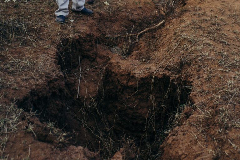
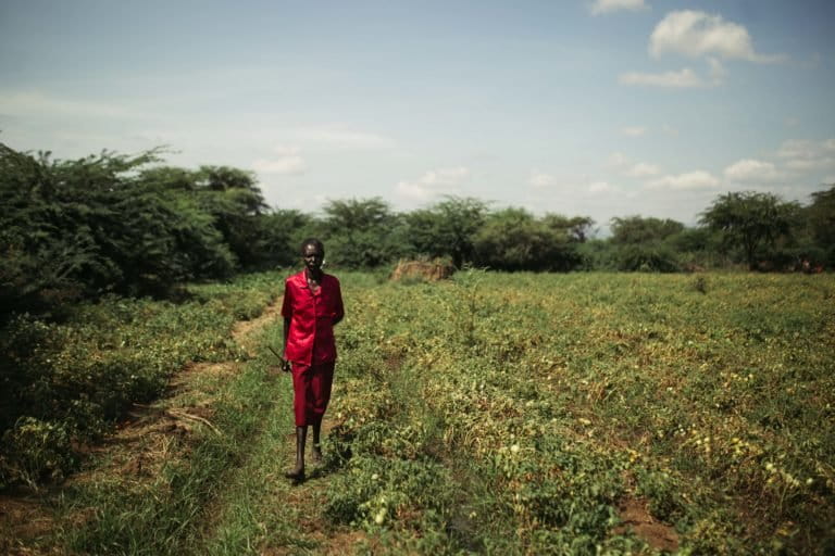
Last summer, Wilfred Kusele, a pastoralist from the Ilchamus community, experienced the shock of his life when a sinkhole appeared in his crop field overnight.
Living in Loropil village along the shore of Lake Baringo, he watched for months as the lake advanced into his field of tomatoes, melons and maize. He marked the rising water levels each day with a stick, until one day in late August last year, the sinkhole appeared.
“When it first happened, it was so deep we couldn’t see the bottom,” Kusele told Mongabay in an interview. The sinkhole had shrunk to approximately 5 meters (16 feet) across by December 2021. “It took seven days for the lake water to fill that hole,” he said.
The water coming out of the sinkhole was warm, indicating geothermal activity. None of the villagers had seen anything like it before.
“People came from the county and national government to take photos and try to make sense of it, but still, no one knows,” Kusele said.
Soon after, several homes, the Loropil primary and secondary schools, and a once heavily trafficked road were flooded due to heavy rainfall and the advancement of Lake Baringo. Displaced villagers and schools have now relocated to Sirinyo village, 11 kilometers (7 miles) from Loropil, on the other side of Marigat, the closest town, which sits 10 km (6 mi) southwest of Lake Baringo. Classes are currently held under trees; these conditions leaves the local students at a distinct disadvantage to those taught in the capital city, Nairobi, Chepsoi said.

Last year, a sinkhole also appeared in the center of an asphalt road by Baringo, which the Kenya Wildlife Service (KWS) repaired, along with another by Lake 94, also in the same region. Given the unprecedented nature of this phenomenon, community leaders are at a loss as to what to do.
“This is the biggest challenge we’ve ever faced,” said Joseph Lenasieku, the chief of 17 villages in Baringo county for more than 30 years now. Lenasieku is among the villagers who relocated to Sirinyo.
Digging into the source of sinkholes
According to Anay Shah, a Kenyan geologist who works in civil and environmental engineering, the main trigger for sinkholes in nine out of 10 cases is water.
“As salt beds or naturally soluble rocks are dissolved by groundwater, spaces open within the rock,” Shah told Mongabay. “There is a definite correlation with extremes of weather and more sinkholes.”
Sinkholes form when the land surface above collapses into cavities, or when surface material is drawn downward into existing voids beneath the water table. They become common in regions where the ground lacks external surface drainage and is composed of soluble material such as limestone, clay, or sand, like in Baringo.

Increases in rains or floods can trigger a sinkhole in a geologically active region by putting accumulated pressure on the ground. Another cause is human activity, which can accelerate the collapse of land over the span of a few years by digging holes along precarious fault lines. Typically, the collapse of land is a process that would take thousands of years.
In Baringo county, all these factors are coming together through the effects and consequences of climate change. Lakes Baringo and Bogoria, 40 km (25 mi) apart, are expanding through increased rainfall. Research documenting and analyzing water level fluctuations in these lakes found that the mean annual rainfall for 2010-2020 has increased by up to 30%. The Ilchamus and Endorois communities sandwiched between Lake Baringo and Bogoria are now worried that the two lakes may join up in the near future, said Geoffrey Tuitoek, a member of the Endorois community.
According to Shah, the alternating cycles of flood and drought have not only severely undermined the resilience of communities living in affected regions, but has also driven communities to dig more boreholes in search of water. This potentially comes at a cost to Baringo county’s naturally loamy landscape, where tremors are normal.

“There’s no cheap way to get quality boreholes,” Shah said. “Excessive drilling weakens the overall structure and can also lead to more sinkholes.”
Residents of Loropil say the geological volatility of their landscape is common knowledge. In some places, for instance, machine-drilled boreholes go no deeper than 50 m (164 ft), while in others they can go as deep as 90 m (295 ft).
Maji Moto, a town east of Lake Bogoria whose name in Swahili translates into “hot water,” has also seen its share of sinkholes. The Great Rift Valley is, after all, a 6,000-km (3,700-mi) chain of trenches, formed from the divergence of three tectonic plates (the Nubian, Somali and Ethiopian). Fault lines here, formations in the Earth’s crust as a brittle response to stress, are especially capricious.
Past the classrooms and football pitch of Maji Moto Secondary School, the jagged vestiges of a sinking fault line run deep. In 2013, clusters of sinkholes had formed without warning. The principal of the school, Enock Kiptaiwa, said they were so deep at first that they couldn’t see the bottom. One of the school’s cows fell in and couldn’t get out; it was left there and buried. Today, the sinkholes are smaller and shallower due to the school’s efforts to fill the holes.
Little national attention
For now, the emergence of the sinkholes in the Endorois and Ilchamus communities hasn’t garnered much attention, as is typically the case. Last year’s extreme floods in Baringo county, during one of Kenya’s wettest years on record in a decade, barely caused a stir nationwide. Lake Baringo’s water level rose and increased the flooded area from 143.6 square kilometers (55.4 square miles) to 231.6 km2 (89.4 mi2) from 2010 to 2013. The Kenya Red Cross was one of the few organizations on the scene. Caleb Kibet, the Red Cross coordinator for the Baringo chapter, said that underserved communities in places like Baringo struggle to receive the necessary attention even when facing immense stress.
At the end of 2020, 88 km2 (34 mi2) of land had been claimed by Lake Baringo.
“Kenya is too used to stories of droughts and flooding,” Kibet said. It was estimated that Baringo, a county with a poverty rate of 52.2% as of 2019, lost 95 million shillings ($839,600) in tourism revenue and infrastructure in 2021 due to floods. “Unfortunately, we are quite pressed for resources here,” Kibet said.
Baringo has received provisions for food aid in the face of the drought, but with considerable difficulty. According to members of the community, the sinkholes have yet to spur the country or the government into action.
Mongabay reached out to the Kenyan government for comments on accusations of neglect, but did not receive a response.
Jeremy Chesire Kemei, an accountant at the EWC, said the Indigenous council is working indirectly to address the causes and ramifications of sinkholes on Endorois communities. Should more sinkholes form, the EWC plans on addressing the concerns accordingly, he said.
The EWC is also working to introduce climate change mitigation strategies in the 17 Endorois villages around lakes Bogoria and Baringo. Besides promoting tree planting through the distribution of native tree species such as umbrella (Maesopsis eminii) and neem (Azadirachta indica), and mango (Mangifera indica) for income potential, the EWC also encourages alternative livelihoods such as beekeeping to alleviate agricultural pressures on land.
Water pushing out people and wildlife
Lately, the rise in water levels has changed the ecology around the lakes, encroached on inhabitable areas, and decreased water quality for agricultural and domestic use. Many aspects of life, already difficult for these communities pleading a case on Indigenous land rights and human rights abuses, have become tougher.
There are concerns from the local government, members of the community and health care workers regarding the rise in coccoid bacteria in floodwater, which often carries infectious organisms such as E. coli and can spark outbreaks of pneumonia and hepatitis A.
The recent shift in lake ecology has also helped propagate invasive species such as mesquite trees (Prosopis juliflora) and prickly pear cactus (Opuntia stricta), which crowd out native species. Mesquites not only divert river flow but also severely deplete water sources in already arid regions with their unusually extensive taproot system, competing with agriculture and pastoralism alike. Diversions also cause over-siltation and lead to problems of sanitation and water quality.

Willy Limo, the curator of KWS’s Community Museum and Snake Park, said that besides reconstructing the physical infrastructure that sinkholes wreak havoc on, the wildlife service’s attention has also shifted to the increase in human-wildlife conflict. Baringo is well known for its crocodiles, snakes and lizards, and as the habitats of humans and animals alike are disturbed, both seek refuge on higher ground — often in the same places.
“Hippos, crocodiles and snakes are all being forced out of their native territories,” Limo told Mongabay. “Although our mission here is to advocate for community education [on human-wildlife coexistence], the rising waters and competition over space don’t help.”
Just the other night, Limo said, he attended to a woman bitten by a cobra in her home. The KWS has had to relocate its own snake park due to the flooding.
Down the road from the KWS office along Lake Baringo, a bask of crocodiles could be seen submerged in the same lake water that had flooded out a pharmacy. They were eyeing a number of pastoralists’ goats nibbling around strewn waste, seemingly oblivious to the inevitable threat.
Changing long-held cultural traditions
Hellen Juma and Sirma Obeta, the sub-county administrators of Marigat, have proposed helping their constituents by building dams upstream to reclaim water flow to reduce siltation. They also want to encourage communities to focus on the quality of cattle breeds rather than simply herd size, which they say is typically the case among pastoralists in Baringo.
The sinkholes, according to the administrators, are singular events — for now. Their current strategy is to address the root problems of climate change and land use. They aim to change the traditional land practices of pastoralists that focus on keeping a lot of cattle and growing maize and millet in the highlands. Juma and Obeta say these practices can no longer be followed as arable land dwindles with flooding, population density increases, and sinkholes pop up.

The efforts have had a mixed reception so far. While communities are interested in expanding traditional beekeeping practices as businesses, for instance, the inclination to maintain other practices remains strong in traditionally pastoral Endorois communities. “I understand the push behind these strategies,” Chepsoi said, “but sometimes they just won’t culturally translate. [Administrators] want people to switch to poultry farming, but there’s not as much of a market for it. [We] Endorois are herders.”
Juma said that although the administrators appreciate Baringo’s cultural diversity, knowledge and value, “Our goal is to bring them toward modernity without causing conflict.”
Lake Baringo receded past the boundaries of pastoralist Wilfred Kusele’s fields in early 2021. However, he said he still feels uneasy about the emergence of sinkholes as he looked over the void left in his field.
“We fear them because we don’t know anything about them,” he said.
Banner image: The view from the shore of Lake Baringo, where the water level has rapidly advanced in recent years. Image courtesy of Kang-Chun Cheng.
Related listening from Mongabay’s podcast: We take a look at restoration projects around the globe and the ways the global ecological restoration movement is challenging us to reconsider the way we live on planet Earth. Listen here:
FEEDBACK: Use this form to send a message to the author of this post. If you want to post a public comment, you can do that at the bottom of the page.