- Researchers have identified alternative routes for a planned mining road that will cut through the Harapan forest, the largest surviving tract of lowland tropical rainforest on the Indonesian island of Sumatra.
- The alternative routes will avoid thousands of hectares of forest loss as they skirt the main forest block while traversing nearby lands that are largely deforested.
- They are also potentially cheaper than the routes planned by coal miner PT Marga Bara Jaya (MBJ) because they utilize existing road networks and improve them.
- Local environmental activists have identified similar alternative routes, but the fact that the company is proposing a more destructive path points to a lack of will to minimize deforestation, poor planning, or a deliberate attempt to cut through the middle of the forest, researchers say.
JAKARTA — A new study strengthens the case for redirecting a planned mining road around the largest surviving tract of lowland tropical rainforest on the Indonesian island of Sumatra, but the company behind the project appears to be staying the course.
The study by researchers at James Cook University in Australia found that rerouting the road along any of five alternative routes that skirt the Harapan forest could spare thousands of acres of forest from being cleared.
These alternative routes traverse nearby lands that are largely deforested, making it more reasonable to build the road there rather than cutting a new path through the forest, said Jayden Engert, a James Cook University doctoral student and lead author of the study.
“The area around the Harapan [forest] has already been extensively cleared and hence there is no need to build through the forest,” Engert said.
All but one of the alternative routes runs a shorter distance than the route being considered by mining company PT Marga Bara Jaya (MBJ), and would thus result in potentially shorter travel times.
The risk of deforestation from human encroachment is drastically reduced with these alternative routes, with up to 3,321 hectares (8,206 acres) less forest loss, the study says.
“The key for alternative routes to have lower environmental impacts are relatively straightforward: avoid cutting through intact natural habitat and avoid creating barriers between intact natural habitat, as much as is possible,” he said.
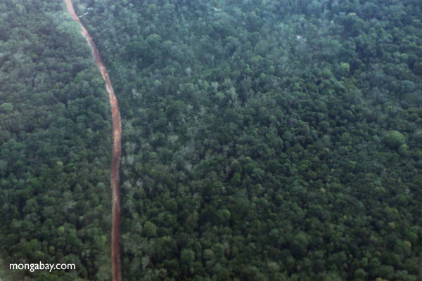
The Harapan forest, whose name in Indonesian means “hope,” spans 76,900 hectares (190,000 acres) in the provinces of South Sumatra and Jambi, and is home to critically endangered species such as tigers, orangutans and elephants. It sits between MBJ’s coal mines and power plants in South Sumatra, and the miner’s plan to build the road through the forest has been panned by conservationists as the single biggest threat to this patch of biodiverse forest in central Sumatra.
MBJ has proposes three potential routes for the road: “outside” the forest; along the “edge” of the forest; and “through” the forest. All three pose a heightened risk of increased forest encroachment and illegal logging, fires, poaching, and mining.
The study projects that human incursions along any of MBJ’s proposed routes will result in 3,000-4300 hectares (7,400-10,600 acres) of forest loss.
With the Harapan forest having already lost 18% of its natural forest due to decades of oil palm cultivation and encroachment, losing more forests would be devastating to the area’s wildlife.
The forest is home to 1,350 known species, including 133 globally threatened species such as the Sumatran tiger (Panthera tigris sondaica), Sumatran orangutan (Pongo abelii) and Sumatran elephant (Elephas maximus sumatranus).
The researchers call the project an “environmental crisis in the making.”
“Populations of endangered orangutans, Asian elephants and Sumatran tigers in the forest could all be severely affected by the planned road, which would allow illegal loggers, miners and poachers to invade,” Engert said.
Of the five alternative routes that the researchers drew up, using computer models and satellite images, two would limit forest loss to about 100 hectares (247 acres), or less than one-fortieth of the deforestation projected under MBJ’s “through” route, said Bill Laurance, a research professor at James Cook University and co-author of the study.
The alternative routes would also bring the project’s cost down significantly, as they call for using and improving existing road networks. For the developer, that would mean building less new roads, which is more costly than upgrading existing roads.
The researchers identified at least 848 kilometers (526 miles) of existing roads in the Harapan forest, and 13,333 km (8,284 mi) in the region immediately surrounding it, which is three to four times higher than official data sources indicate. Ultimately, the alternatives proposed in the study would require building one-and-a-half to three times less new roads than MBJ’s proposed routes.
“By prioritizing areas that already have roads, especially larger roads, we could avoid areas where construction costs would be high — such as sites with steep slopes or those that lack existing bridgeworks or river crossings,” the study says.

Poorly planned
Engert said it’s very simple to identify the alternative routes as there are myriad studies on using least-cost path analysis to identify routes for roads, power lines, pipelines and other linear infrastructure.
“The method we used is a well-established practice in land-use planning,” he said. “So if the will was there it should have been very easy for the company [MBJ] to identify alternative routes on its own.”
Engert added that activists from the group People’s Forum of South Sumatra-Jambi Forest Rescuer (FORMAPHSI) have also identified alternative routes very similar to the ones modeled by the researchers.
“This to me is a strong statement that two groups, independently, arrived at similar, more environmentally friendly alternatives,” he said.
The fact that MBJ came up with routes that have such a high impact on the Harapan forest points to either lack of information or lack of will, which in turn leads to poor planning, Engert said.
“It is difficult to escape the impression that plans for the Harapan mining road were devised with little attention to their environmental and socioeconomic impacts and overall cost,” the researchers said.
Another possible explanation behind the poor choice of routes is that the company intentionally planned to increase access to the Harapan forest, Engert said.
While the forest is currently managed by various NGOs as an ecological restoration concession, it’s still legally classified as a production forest, he said. This means the forest is designated for exploitation of timber and other forest products.
“Or [the company] intentionally planned to avoid existing road locations to avoid dealing with the logistics of improving existing infrastructure,” Engert said.
MBJ has in recent months started to collect data and mark a route through the forest that will be cleared, according to FORMAPHSI.
“It’s likely that the route marking will be used by MBJ to make an inventory of trees, which is required by law, before [the company] cuts down trees and clears land for the coal mining road,” said Haris Alamsyah, the investigative coordinator at FORMAPHSI’s South Sumatra chapter.
Mongabay reached out to MBJ’s operational manager, Adi Wahyudi, for comment, but he didn’t respond.
If the mining road is poorly planned, then it’s unlikely to be able to yield economic growth and other benefits for rural populations, the researchers said.
That makes the use of strategic planning, like what the researchers did to identify the alternative routes, crucial to avoid poor planning so that the mining road can improve socioeconomic outcomes for rural residents and Indigenous peoples by boosting their access to markets, education and health care.
Strategic planning can also reduce the environmental toll of new road projects by avoiding critical ecosystems and wildlife habitats.
“With scientific approaches like those we’ve devised, we have a fighting chance to protect Earth’s endangered ecosystems while still meeting the needs of a growing planet,” Engert said.
Banner image: Logged and degraded Harapan Rainforest in Jambi, Indonesia. Image by Rhett A. Butler/Mongabay.
Citation:
Engert, J. E., Ishida, F. Y., & Laurance, W. F. (2021). Rerouting a major Indonesian mining road to spare nature and reduce development costs. Conservation Science and Practice. doi:10.1111/csp2.521
Related listening from Mongabay’s podcast: A discussion of the Trans-Sumatran Highway about its route and impact on wildlife with two experts, listen here:
FEEDBACK: Use this form to send a message to the author of this post. If you want to post a public comment, you can do that at the bottom of the page.