
- Authorities are battling an outbreak of wildfires in eastern Bolivia’s Chiquitania region.
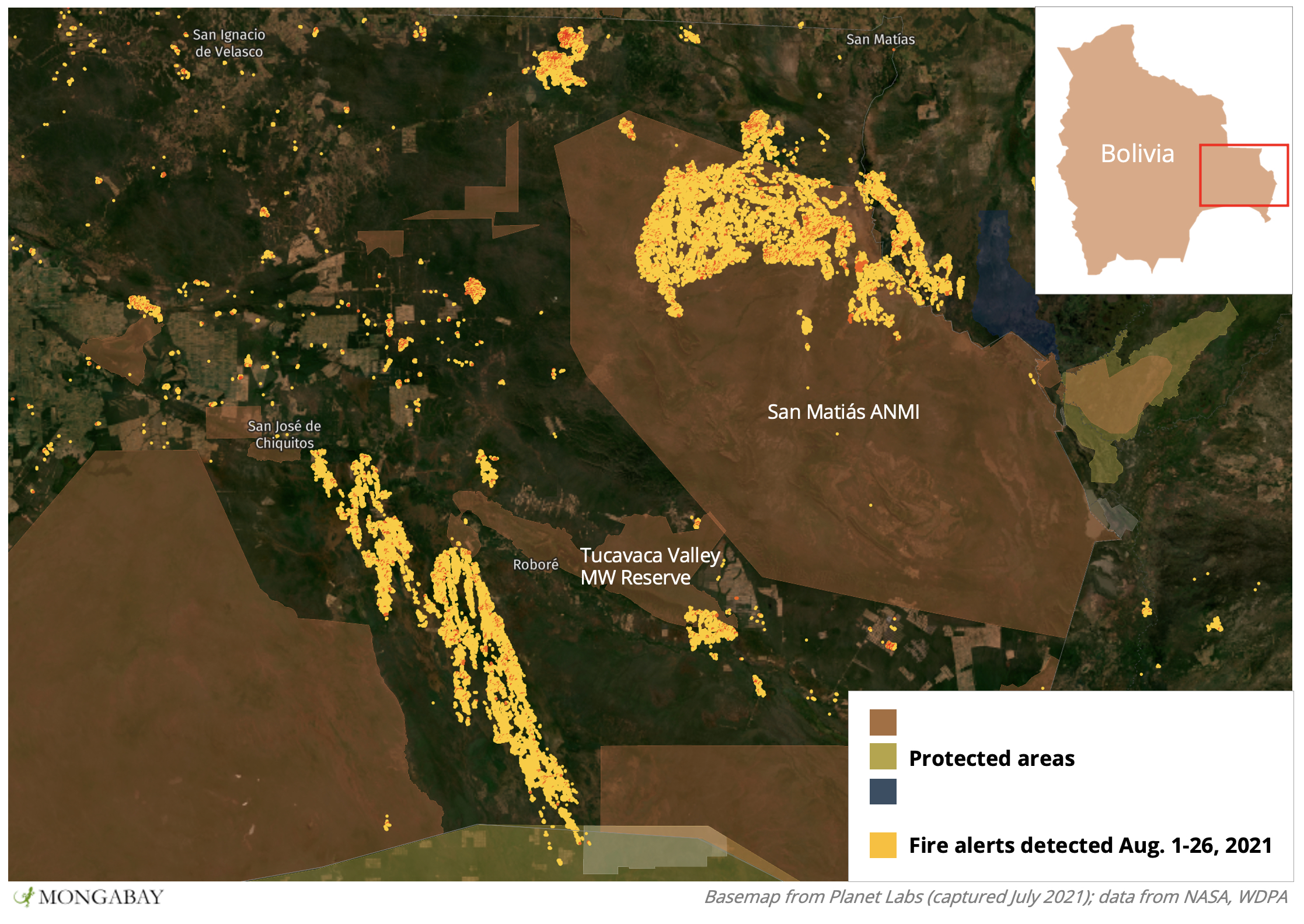
- Satellite data show fires have intensified over the past two weeks and are invading protected areas.
- The fires are destroying habitat spared by Bolivia’s extreme fire season of 2019.
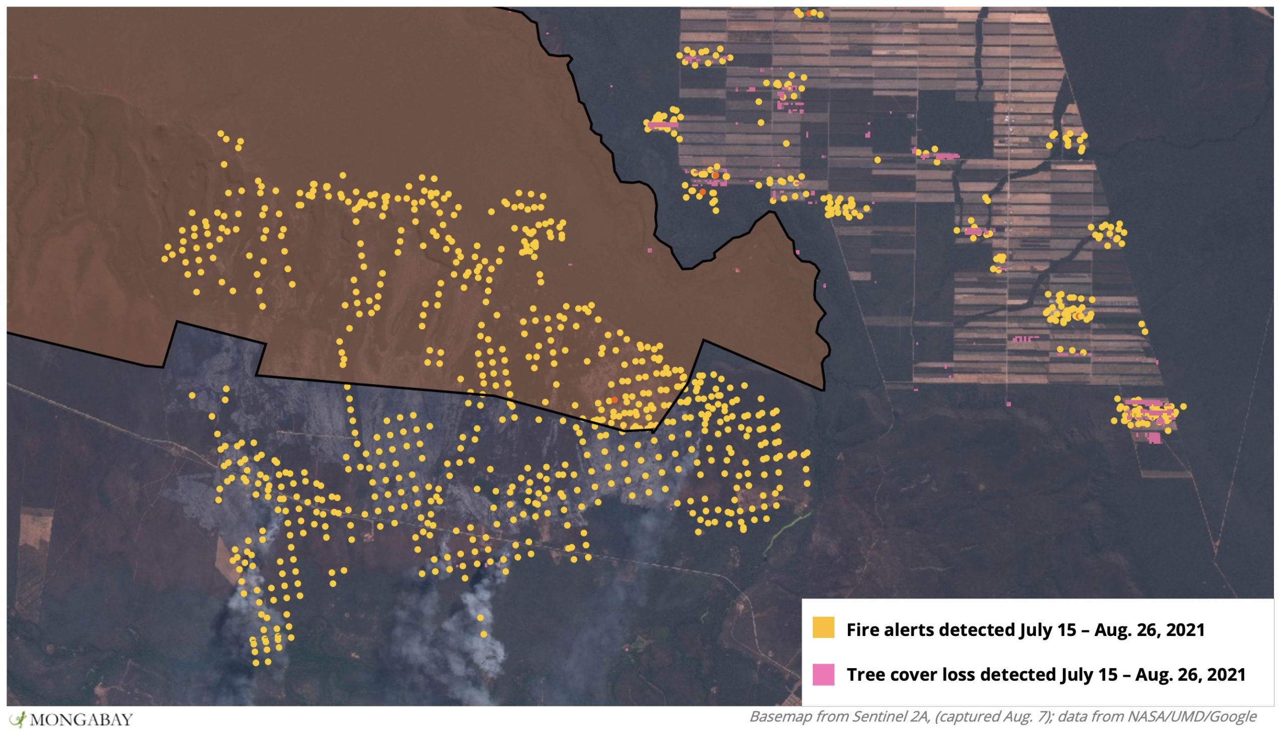
- Wildfires in Bolivia are often associated with burning for agriculture, and satellite data and imagery show recent fires on agricultural land that directly preceded nearby blazes that have spread into protected forest.
Two years ago, fire ravaged the Tucavaca Valley Municipal Wildlife Reserve in the heart of Bolivia’s Chiquitania region, wiping out thousands of square kilometers of habitat. Now this threat has returned, with fires raging once again in the reserve and the surrounding area.
Tucavaca Valley is located in the municipality of Roboré near Bolivia’s border with Brazil. Designated in 2000 and covering some 262,300 hectares, Tucavaca Valley Municipal Reserve encompasses an important portion of the Chiquitano dry forest ecoregion, which houses the headwaters of rivers that feed the larger region – including Bolivia’s Pantanal wetland.
Alarm was sounded on Aug. 1 when fires broke out along a highway just south of the reserve and, propelled by high winds, quickly grew out of control. Three days later, the fire entered the Tucavaca Valley reserve. Authorities from the municipality of Roboré, aided by those from regional and federal governments, sprang to action and were able to get that particular fire under control. But satellite data from the U.S. National Aeronautics and Space Administration (NAS) show more fires have broken out and spread through Tucavaca Valley reserve and other protected areas in the region such as San Matiás Natural Area of Integrated Management (ANMI), gobbling up forest and other habitat as they grow.

Most fires in Bolivia are caused by agricultural burning to clear land and make it more suitable for cultivation. In July 2019, then-President Evo Morales approved an amendment to Supreme Decree 26075 on Permanent Forest Production Lands that would increase the amount of land demarcated for agribusiness in the departments of Beni and Santa Cruz. The decree authorizes land clearing for agricultural activities in private- and community-held areas that operate under an integrated system that blends sustainable forest and resource management. It also allows controlled burning in accordance with current regulations.
Despite the current fire crisis and the high risk for subsequent breakouts, satellite data and imagery show fires burning in areas used for industrial agriculture immediately surrounding Tucavaca Municipal Wildlife Reserve and San Matiás ANMI.
“The fire entered the Tucavaca Valley protected area and has spread to the foothills of the mountain range …. Within the protected area, the fire is inside a canyon, making access difficult and preventing us from reaching it,” Richard Rivas, Director of the Tucavaca Valley Municipal Reserve, told Mongabay in early August as they battled the initial fire in the reserve.

The Chiquitano is the world’s largest remaining area of healthy dry forest ecosystem and one of its most biologically diverse. Jaguars (Panthera onca) prowl through its sparse jungle and grasslands, as do cougars (Puma concolor), giant armadillos (Priodontes maximus), tapirs (Tapirus terrestris), ocelots (Leopardus pardalis) and maned wolves (Chrysocyon brachyurus). The ecoregion is still relatively unstudied, but scientists suspect it contains species that live nowhere else in the world.
Vice Minister of Civil Defense Juan Carlos Calvimontes added that a team of experts has been deployed to help contain the spread of the fires.
“Yes, we are aware of the fire, and it is being dealt with, as are all the fires that have broken out in Santa Cruz,” Calvimontes said.


The fires are destroying habitat in areas that had escaped Bolivia’s unprecedented fire season of 2019 when 3.6 million hectares burned – an area the size of Taiwan.
Director of Risk Management for the municipality of Roboré Luis Fernando Mendoza said that an Incident Command has been established in the community of El Naranjal, 70 kilometers (43 miles) from Roboré. Mendoza said they are able to support responders with special clothing, but lack other resources that would allow firefighters to more effectively and safely battle the blazes.
“It is hard work, and we need support to provide all the necessary personal protective equipment. The Santa Cruz Governor’s Office has provided us with clothing and tools because we had nothing, and the Roboré Mayor’s Office budget is now running low,” Mendoza said.

Tucavaca Municipal Wildlife Reserve is one of the few community-facilitated protected areas in Bolivia, according to Rivas.
“It was [established] at the request of local residents who wanted the highlands and the Tucavaca Valley to be protected,” Rivas said.
For local residents, Tucavaca Municipal Wildlife Reserve is not only a source of water, but also a source of livelihood. To supplement small-scale agriculture, families living in the communities of Santiago de Chiquitos, Roboré, Chochís and Aguas Calientes receive income from tourists lured by the region’s natural attractions. The COVID-19 pandemic had already put a big dent in the region’s ecotourism industry, and residents worry the fires will make a bad situation even worse.
This story is a translated and updated version of one reported by Mongabay’s Latam team and first published in Spanish on our Latam site on August 7, 2021.
Banner image: Wildfire in the municipality of Roboré municipality. Image by María Valarde.
Editor’s note: This story was powered by Places to Watch, a Global Forest Watch (GFW) initiative designed to quickly identify concerning forest loss around the world and catalyze further investigation of these areas. Places to Watch draws on a combination of near-real-time satellite data, automated algorithms and field intelligence to identify new areas on a monthly basis. In partnership with Mongabay, GFW is supporting data-driven journalism by providing data and maps generated by Places to Watch. Mongabay maintains complete editorial independence over the stories reported using this data.
Feedback: Use this form to send a message to the editor of this post. If you want to post a public comment, you can do that at the bottom of the page.