- Conservationists around the world have increasingly turned to technology to adapt and respond to rising challenges in protected areas.
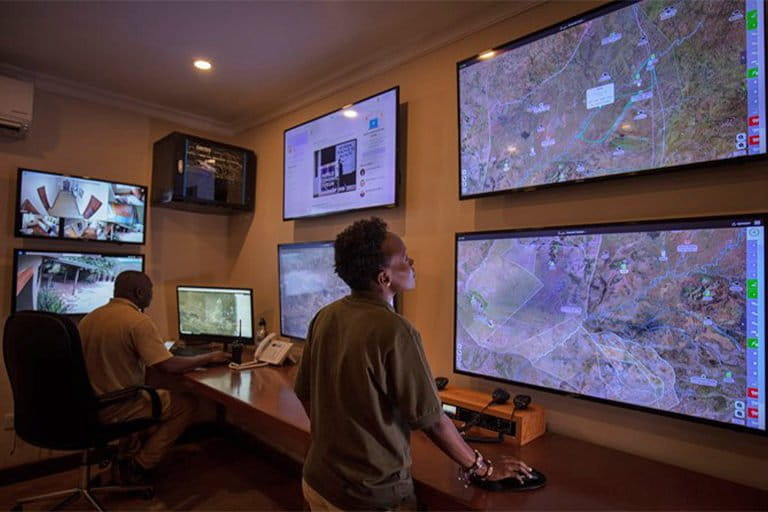
- One example is EarthRanger, which collects and integrates information from several remote sensors and allows users to visualize data under one platform.
- The software solution helps conservationists with security, ecological management, and human-wildlife conflict, by streamlining conservation data into a system that helps them make informed decisions rapidly.
- While promising, the technology has encountered teething problems: lack of internet infrastructure, the need for an extensive network of sensors, and high data literacy to use the technology.
In recent years, new and emerging technologies have revolutionized conservation work. At the forefront of this transformation is EarthRanger, a protected-area management software that was developed by Vulcan Inc. in 2017 and is currently used in several protected areas around the world.
The conservation tool collects and shares information on a single online platform that helps conservationists combat a wide range of problems. For instance, it helps operational teams and scientists protect wildlife, understand ecological changes, combat human-wildlife conflict, and prevent poaching and other threats like deforestation.
“[EarthRanger] is data aggregation and visualization system that integrates many different data input sources,” says Jes Lefcourt, senior director of conservation technology at Vulcan.
These sources include rangers, vehicles, aircraft, field-based events and wildlife-tracking devices, as well as various other sensors. The program then “combines all of that information together in an easy-to-use interface,” Lefcourt adds, allowing conservationists to operate both reactively and proactively.
Focusing on three main areas — security, ecological management, and human-wildlife conflict — EarthRanger is used by conservationists at 170 different organizations operating in 40 countries across five continents.
Conservation technology, like many other kinds of remote technologies, has proved to be extremely useful during the COVID-19 pandemic, according to a survey commissioned by Vulcan. Over the past 18 months, 67% of conservation technology users said their ability to engage in fieldwork had deteriorated, and 54% said their budgets had gotten worse. At the same time, the economic downturn sparked by various forms of lockdowns has driven a surge in illegal wildlife activity, such as trading, poaching and illicit fishing, in a number of regions, according to the survey, highlighting the impact of the pandemic on conservation efforts around the world.
The survey also highlights the critical role technology has played in addressing these challenges, with 81% of survey respondents agreeing that technology has helped them adapt or respond to the impacts of COVID-19 on protected areas.
One of the ways EarthRanger is aiding conservationists in the field is by alerting management teams when certain threats are picked up by sensors on the ground. Jake Wall, director of research and conservation at the Mara Elephant Project (MEP) in Kenya and one of the original architects of EarthRanger, frequently uses real-time data from trackers to locate the area’s elephants (Loxodonta africana) and deploy rangers based on that information.
This information is easy to find under one platform, alongside data on the speed and direction the elephants are traveling and how close they are to park boundaries. If the elephants go near human settlements, EarthRanger will send an alert to rangers, allowing them to respond before an incident takes place.
“We’ve also had several situations where elephants have thrown a slow-speed alarm,” Wall told Mongabay, which occurs when elephants travel slower than their normal pace. This often means an elephant has been injured and requires treatment. Since the pachyderms are easy to locate through the system, the nearest team of rangers can be alerted immediately.
But as with any technology being implemented in the field, there are challenges and drawbacks. For example, EarthRanger requires good infrastructure and internet availability. For the software to run, each site needs certain tools, such as tracking devices and sensors to collect and access the data.
In forest environments, it’s much more difficult to use these systems due to the dense canopy. Rough terrain can make areas harder to access, slowing down response speed dramatically.
For 51 Degrees Limited, a security company with management oversight of the Ol Pejeta and Lewa wildlife conservancies in Kenya, EarthRanger has become a central part of day-to-day operations. Staff use the software to collect and analyze huge amounts of data, allowing them to better understand the landscape, make more accurate predictions, and respond in a much more coordinated manner than ever before.
“[It’s] part of [their] everyday life and decision-making,” said Batian Craig, director of 51 Degrees Limited, as it allows them to “analyze and understand the data that’s come in and identify where [they] lack input.”
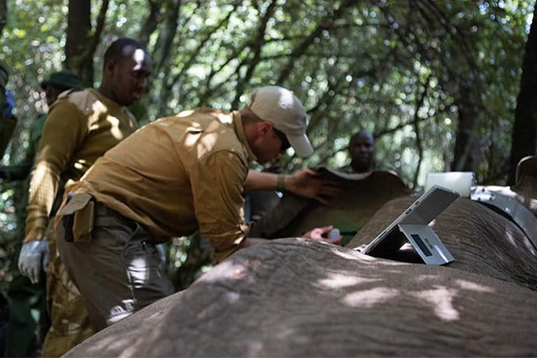
EarthRanger has also evolved a number of apps that respond to more specific needs. In 2013, Vulcan helped design the STE tracking app with Save the Elephants (STE), a custom-built iOS app that allows them to better understand the behavior of individual elephants.
“We have to be able to understand them in order to secure them a future,” said Frank Pope, chief executive of STE. “The better we can understand them, the better we can help them. It’s comprehending elephant behavior in a way that will allow you to develop solutions to help farmers and keep those elephants out of trouble.”
But again, these solutions still require a large number of supporting tools, such as tracking devices and camera traps. STE currently tracks around 30 elephants in an area that’s home to roughly 17,000 of the pachyderms. In areas where few elephants are tracked, the organization uses aircraft to collect data. “This allows us to gather additional information that can help us interpret their movements,” Pope said.
Several organizations have set up a fund to ensure greater access to the devices needed for the effective use of EarthRanger.
STE has partnered with the Wildlife Conservation Network and the Leonardo DiCaprio Foundation to set up an Elephant Crisis Fund (ECF) that helps raise money to support projects across Africa and around the world. “What we are doing is funding people to deploy collars on elephants, trackers on rangers and integrate EarthRanger so they can also benefit from these tools,” Pope said.

“Thankfully there is a large increase in the adoption of technologies throughout protected areas,” Lefcourt said. “There certainly are still sites that are in the middle of nowhere which don’t have these devices and EarthRanger can’t really help them,” as a degree of infrastructure is still necessary.
Another problem comes down to managerial challenges.
“EarthRanger is a tool and it’s only ever as good as the tools applied. It’s important that there’s effective management in order to make good use out of it,” Lefcourt said.
Employing EarthRanger requires training and a certain amount of data literacy, leading to stricter requirements when hiring rangers, according to Wall.
Nonetheless, the technology has led to positive outcomes outside conservation work, assisting with humanitarian issues like the locust plague in Ethiopia last year that threatened the food security of 34 million people. Working in partnership with the U.N.’s Food and Agriculture Organization (FAO), Vulcan created a custom configuration of EarthRanger to analyze information from eLocust3m, a mobile tracking tool used to collect data on locust behavior and movements. This was then used by 51 Degrees Limited to locate and kill swarms, allowing them to make informed decisions on how best to respond.
This goes to shows the diversity of the tool, according to 51 Degrees’ Craig, “and how incredibly powerful EarthRanger is in stepping out of the conservation space to essentially work on resolving humanitarian issues in a coordinated manner as well.”
Banner image: One of Save the Elephants’ field researchers, David Letitiya, tracking elephants with the Save the Elephants app powered by EarthRanger. Photo courtesy Frank af Petersens for Save the Elephants
Editor’s note: This story was supported by XPRIZE Rainforest as part of their five-year competition to enhance understanding of the rainforest ecosystem. In respect to Mongabay’s policy on editorial independence, XPRIZE Rainforest does not have any right to assign, review, or edit any content published with their support.