
- Honduras’ Río Plátano Biosphere Reserve occupies a large portion of the country’s eastern region.
- However, despite official protection and recognition as a UNESCO World Heritage Site, Río Plátano is plagued by deforestation; satellite data show the biosphere reserve lost 13% of its primary forest cover between 2002 and 2020.
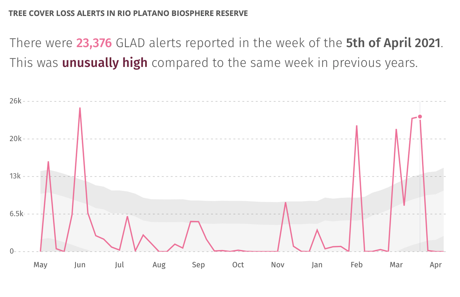
- Deforestation shot up in 2020, nearly doubling the amount of forest loss over 2019. 2021 may be another rocky year for the biosphere reserve, with satellite data showing several “unusually high” spikes of clearing activity so far this year.
- Sources say deforestation in the reserve is being driven by logging, agriculture and the drug trade.
Tucked away on the Caribbean side of Honduras lies the Río Plátano Biosphere Reserve, an area some in size with abundant green forests, rivers, ponds, and a great variety of wildlife. Because of its natural richness, the United Nations Educational, Scientific, and Cultural Organization (UNESCO) declared it a World Heritage Site in 1980.
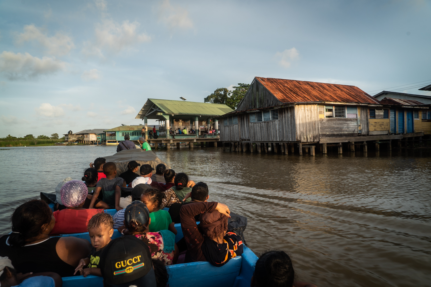
The Río Plátano Biosphere Reserve, which can only be reached by air, sea or river, and is divided into three areas: a buffer zone, a zone, and a cultural zone. The buffer and core zones cover a large part of the departments of Colón and Olancho, while the cultural zone is located in the Gracias a Dios department. Gracias a Dios includes six municipalities (Puerto Lempira, Brus Laguna, Ahuas, Juan Francisco Bulnes, Wampusirpi, and Villeda Morales) and is home to around 100,000 people.
Much of the reserve’s natural beauty is contradicted by three phenomena that have become more prevalent in the last two decades: the extreme poverty of its inhabitants, a strong presence of drug trafficking, and massive deforestation reportedly at the hands of logging and livestock companies and the illicit drug trade.
Satellite data from the University of Maryland (UMD) visualized on forest monitoring platform Global Forest Watch show deforestation escalated dramatically in Río Plátano in 2020, nearly doubling the amount of primary forest lost in 2019. Preliminary data from UMD’s Global Land Analysis and Discovery (GLAD) lab suggest 2021 may be giving 2020 a run for its money, with several “unusually high” spikes of tree cover loss in February, March and April. The data show that, overall, the biosphere reserve lost 13% of its primary forest cover between 2002 and 2020.


According to José Manuel Alemán, the regional manager of the Forest Conservation Institute (ICF) in Río Plátano, the biosphere reserve loses an average of 2,700 hectares (about 6,672 acres) of forest per year. He said most of this forest loss is due to the setting of fires to make room for crops and cattle.
Alemán said that 50% of the biosphere’s land belongs to the Miskito and Pech Indigenous communities, and that they are being stripped of their territory through irregular land purchases for the exploitation of natural resources.
“Land grabbing and illegal occupation is something that we cannot hide, and this obstructs the environmental processes that the communities do using their forest management plans,” Alemán said. Alemán also acknowledges that there are armed groups who operate in the territory.
According to Alemán, ICF’s research found that between 2016 and 2020 the biosphere lost around 39,000 hectares (about 96,730 acres) of forest. In other words, each day an average of 21.4 hectares (about 54 acres) of forest was cleared. The municipalities of Dulce Nombre de Culmí (in the Olancho department), Iriona (in the Colón department), and Brus Laguna (in the Gracias a Dios department) presented the highest levels of deforestation, mostly because of cattle ranching pressure from families that have territorial control as well as the illegal extraction and sale of timber, such as Honduran mahogany (Swietenia macrophylla).
Satellite data from UMD show particularly high levels of recent tree cover loss in three municipalities of Río Plátano: Brus Laguna, Juan Francisco Bulnes and Iriona, which all also lost considerable amounts of forest in 2020.
UMD data show Brus Laguna had 368,000 hectares (about 909,348 acres) of forest cover in 2000, which extended over about 83% of its territory. In 2020 alone, the municipality lost around 12,000 hectares (about 29,650 acres) – or 3.3% – of its tree cover, which released an estimated 4.67 million metric tons of CO2. The municipality of Juan Francisco Bulnes, meanwhile, had 65,300 hectares of tree cover in 2000 and lost 4% of that in 2020, releasing 1.04 million tons of CO2. Satellite data show Iriona lost 25% of its tree cover between 2001 and 2020.
Alemán said that together with Indigenous communities, the ICF has issued multiple complaints to the Environmental Prosecutor’s Office for the environmental crimes committed by companies and individuals, but up to this point, “not even one has resulted in judicial action.” The spokesperson for the Prosecutor’s Office, Yuri Mora, told Mongabay Latam that they did not have the authority to speak about the matter.
Osman Alvarado is the president of the Sico Paulaya Environmental and Production Board in Iriona. For over 10 years, the organization has worked to integrate various community organizations. Using international funding, they incentivize the cultivation of cacao, bananas, and mahogany in the Río Plátano Biosphere Reserve. They aim to reforest the areas that have been degraded while using agroforestry techniques – in which crops and native trees cohabitate – to ensure income for the population. However, Alvarado recognizes that the region is largely controlled by livestock systems.

Alvarado says that he is aware that livestock produce a large proportion of the food that people in his municipality consume. In addition to providing milk, cheese and meat, the cattle ranching industry is a source of employment for many young people. In fact, Iriona is one of the municipalities that produce the most milk in Honduras, according to the Ranchers’ Association of Honduras.
But Alvarado pointed out that the exclusive use of land for livestock is causing a large environmental toll. “When you come to Iriona, you grow tired of seeing enormous properties that are fenced in and deforested because the landowners cut down the trees to plant grass. The fewer trees, the more livestock, [which brings] more money,” Alvarado said. Additionally, he said that in the last few years the temperature has increased and in the middle of summer the sky is covered in gray clouds that do not bring rain. Instead, they are clouds of smoke from the fires in the mountains.
Alvarado complained that the authorities do not respect the laws because they allow livestock in Río Plátano. Although the community organizations do not have the official data on the number of hectares destined to become pasture (they say this information is hidden from them), they say that the reality is alarming because every day they see trucks leaving the area while carrying tons of trees to timber markets.
Mongabay Latam requested to speak to Iriona’s mayor, Colón Wilmer Guzmán, and to the director of the area’s Environmental Prosecutor’s Office, but they did not respond.

The Moskitia Asla Takanka (“Unity of La Mosquitia”) Association (MASTA) encompasses several communities in the Gracias a Dios department. Orlando Calderón, an Indigenous leader and member of the association, says that the Indigenous people have historically used the forest in harmony for their survival. They have protected the forest because they recognize that it is the source of life for its people. However, Calderón says that with the interference of government institutions, the door has been opened for companies and landowners to invade their territory and extract their resources, “condemning us to extreme poverty.”
“Starting in the 1980s, the government intervened in our territories using the [ICF] for the administration of the forest, disrespecting our culture, which caused foreigners to come to the Río Plátano Biosphere to enrich themselves more,” Calderón told Mongabay. Calderón said he finds it unjust when some authorities attribute the destruction in the reserve to the activities of Indigenous people.
“Part of the destruction is also caused by the drug traffickers, who deforest in order to construct their secret trails, plantations and drug labs. Also, [part is due to] the foreign companies who come to do scientific experiments in the rivers, sea and ponds,” said an Indigenous leader from the area who spoke to Mongabay on condition of anonymity due to security concerns. According to Insight Crime, in 2020 the Honduran Army destroyed between 18 and 23 secret trails used to move drugs in the municipality of Brus Laguna, which is an area that has long been ravaged by drug trafficking activity.
Insight Crime highlighted that many of the drug seizures took place in the La Mosquitia region, which it described as a crucial corridor for the transport of drugs. On one occasion, the military intercepted a fishing boat with 900 kilograms (about 1,984 pounds) of cocaine and a small plane loaded with 806 kilograms (about 1,777 pounds) of cocaine in the department of Gracias a Dios, where part of the Río Plátano Biosphere Reserve is located.

The anonymous Indigenous leader said that although the Río Plátano Biosphere Reserve is an important environmental area for Honduras, and even for neighboring Nicaragua, the government is not creating policies that contribute to the reserve’s conservation. He said that they instead grant forest management plans and concessions to companies and individuals who see the reserve as an area of business, often without considering the lives of Indigenous communities.
Calderón believes that the destruction of the Río Plátano Biosphere Reserve began when it was declared a protected area and a World Heritage Site, “because it was taken from the Indigenous [people] and given to people who only see the forest as money.” MASTA has proposed to the Honduran government that the reserve’s management be put into the hands of the communities. They say that they have the ability to conserve and reforest the entire reserve in a period of 20 years. He said that the only responses that they have received from the government, however, are criminalization, persecution and a lack of consideration that has led to the assassination of some leaders.
This is a translated and adapted version of a story that was first published by Mongabay Latam on April 05, 2021.
Banner image: An aerial view of the Plátano River in the Honduran department of Gracias a Dios. Image courtesy of Radio Progreso – Honduras.
Editor’s note: This story was powered by Places to Watch, a Global Forest Watch (GFW) initiative designed to quickly identify concerning forest loss around the world and catalyze further investigation of these areas. Places to Watch draws on a combination of near-real-time satellite data, automated algorithms and field intelligence to identify new areas on a monthly basis. In partnership with Mongabay, GFW is supporting data-driven journalism by providing data and maps generated by Places to Watch. Mongabay maintains complete editorial independence over the stories reported using this data.
Feedback: Use this form to send a message to the editor of this post. If you want to post a public comment, you can do that at the bottom of the page.