
- Triunfo do Xingu Environmental Protection Area lies in the ecologically rich Xingu Basin in the Brazilian Amazon and spans some 1.7 million hectares (4.2 million acres) — an area more than half the size of Belgium.
- Despite its protected status, the area has been heavily deforested, losing 476,000 hectares (1.18 million acres) of humid primary forest between 2006 and 2020, according to satellite data from the University of Maryland (UMD), a 32% decrease in total forest cover.
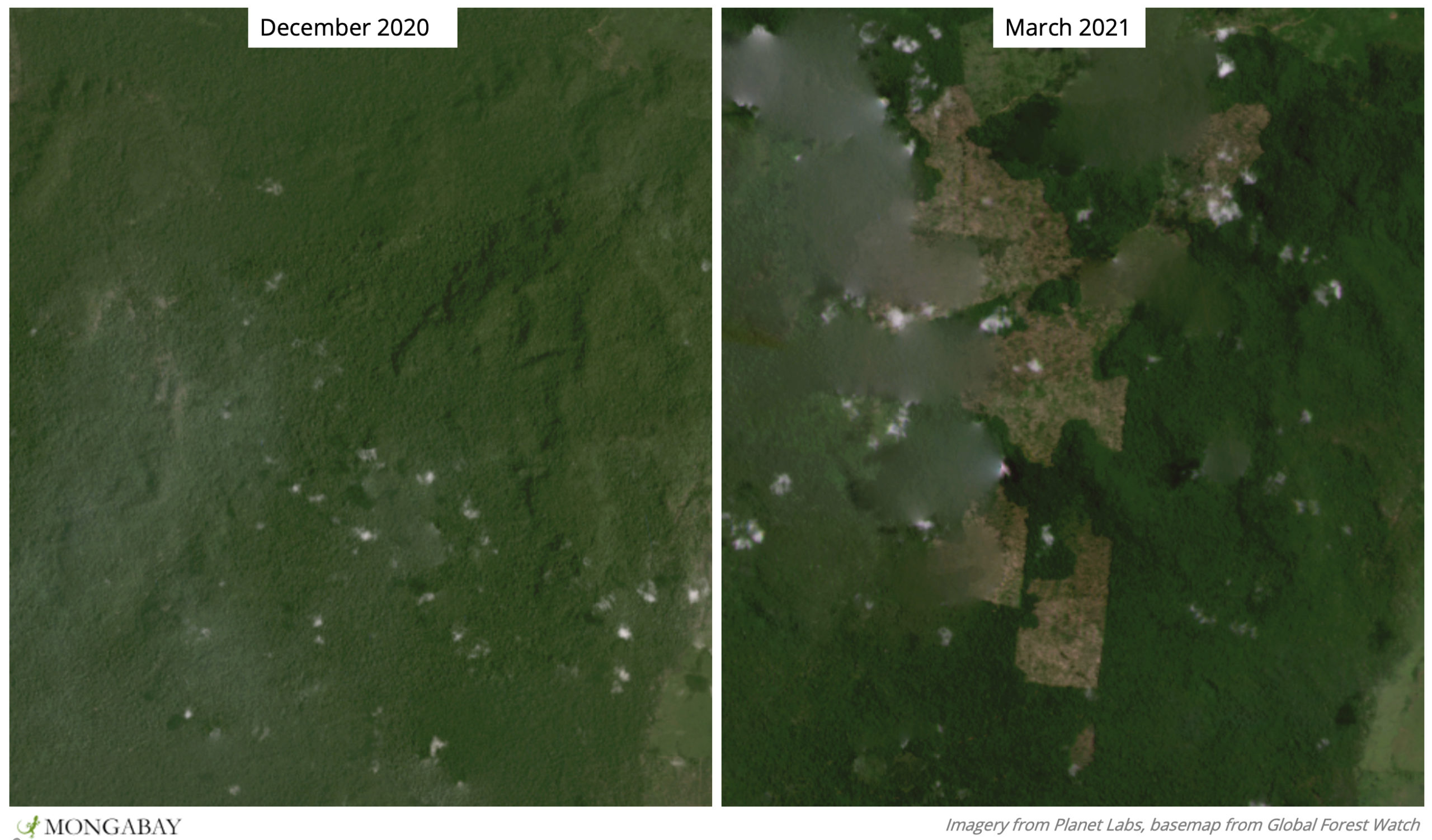
- 2020 saw the highest amount of forest loss since the creation of the protected area, nearly 70,000 hectares (173,000 acres) — an area nearly the size of New York City; preliminary data show clearing of Triunfo do Xingu’s forests has continued into 2021, with “unusually high” levels of deforestation detected the week of March 15.
- Deforestation in the region is largely driven by cattle ranching, and sources say the invasions of Triunfo do Xingu are aided by its remoteness as well as lax enforcement of environmental regulations.
Forest loss in Brazil’s lush Triunfo do Xingu Environmental Protection Area marches on, driven largely by a hunger for beef, emboldened land grabbers, and a lack of law enforcement.
Triunfo do Xingu lies in the ecologically rich Xingu Basin in the Brazilian Amazon and spans some 1.7 million hectares (4.2 million acres) — an area more than half the size of Belgium.
The area came into federal protected status in 2006. Within its bounds, landowners are required to keep 80% of forests intact. The protected area was created not only to preserve the flora and fauna within, but also to serve as a protective buffer for vulnerable surrounding areas, such as the Apyterewa Indigenous Territory and the Terra do Meio Ecological Station

However, despite its protected status, the area has been heavily deforested, losing 476,000 hectares (1.18 million acres) of humid primary forest between 2006 and 2020, according to satellite data from the University of Maryland (UMD), a 32% decrease in total forest cover.
2020 saw the highest amount of forest loss since the creation of the protected area, nearly 70,000 hectares (173,000 acres) — an area nearly the size of New York City.
Preliminary satellite data collated by the Global Land Analysis and Discovery at UMD show clearing of Triunfo do Xingu’s forests has continued into 2021, with “unusually high” levels of deforestation detected the week of March 15.

“[The area] has been under partial environmental protection for more than a decade with the aim of preserving the rich biodiversity of the region while allowing for some very moderate development in a small part of it,” journalist Ana Ionova reported in a 2019 video for Mongabay. “In reality what has actually happened is the territory has lost about one-fifth of its forest cover in that time period.”
Previous reporting in 2020 found that deforestation in the region is largely driven by cattle ranching. In São Félix do Xingu municipality, where the protected area lies, there are nearly 20 times more cattle than people.
Farmers and ranchers in the Amazon use slash-and-burn techniques to clear forest for pasture. In the wet season, forests are cut down and left to dry. After a few months have passed, and as the dry season begins in July and August, these deforested areas can be set on fire and burned over clearing the way for pasture.
Consequently, the Triunfo do Xingu protected area has seen an increase in fires over the past decade. There were 2,668 high-confidence VIIRS fire alerts reported in the past year alone, an unusually high number compared to previous years going back to 2012, according to UMD data visualized on the forest monitoring platform Global Forest Watch.

Protecting Triunfo do Xingu from illegal deforestation and fires has proven extra challenging because it is remote, accessible primarily by boat from the town of São Félix do Xingu. Local sources say on-the-ground monitoring, control, and the capacity to prosecute those who deforest and set illegal fires has been limited across Brazil, as government agencies and law enforcement that once operated in the Amazon have been largely defunded under the current administration.
“The problem is that a lack of land oversight led to this area being more and more occupied, more and more threatened,” Francisco Fonseca, who works for The Nature Conservancy (TNC), a conservation NGO, said in a July 2020 interview. “And this will now only worsen going forward.”
Additionally, land grabbers have been emboldened in recent years. Under former president Michel Temer and now his successor, Jair Bolsonaro, the government has issued amnesties to land speculators who have invaded conservation units and often then use fire to convert forest on public lands to private agricultural lands. Bolsonaro has also vowed to open Indigenous lands to development and spoken out against environmental protections.
“These signals from the government of tolerance towards deforestation and towards land-grabbing — this is feeding the invasion of these Indigenous lands,” Danicley de Aguiar, an Amazon campaigner with Greenpeace, said in a 2020 interview with Mongabay.

The surrounding Xingu Basin is made up of 28 conservation areas and 18 Indigenous territories. Advocates say that as forests here and elsewhere in the Amazon are lost and fragmented, Indigenous people face increased pressures and threats to their survival.
“When we see destruction of the forest … what you’re seeing is the destruction of the ability of these people to continue their way of life,” Christian Poirier, program director at the nonprofit Amazon Watch, told Mongabay in 2019. “They need to have enough forest in which they can practice traditional hunting and gathering and continue their nomadic lifestyle.”
According to Brazil’s national space research institute, INPE, more than 1.1 million hectares (2.7 million acres) of forest cover loss was detected in the Brazilian Amazon between July 2019 and July 2020 — an area the size of Jamaica. Half of this deforestation was in the state of Pará, home to the Xingu Basin.
“While Brazilian deforestation has decreased significantly over the past 15 years,” Mikaela Weisse and Katie Lyons of the World Resources Institute told Mongabay in 2018, “the clearing in Triunfo do Xingu and elsewhere in the Amazon indicate that the battle against clear-cutting of primary forest is not over.”
Banner image: Cattle in Triunfo do Xingu Environmental Protection Area. Image by Ana Ionova for Mongabay.
Editor’s note: This story was powered by Places to Watch, a Global Forest Watch (GFW) initiative designed to quickly identify concerning forest loss around the world and catalyze further investigation of these areas. Places to Watch draws on a combination of near-real-time satellite data, automated algorithms and field intelligence to identify new areas on a monthly basis. In partnership with Mongabay, GFW is supporting data-driven journalism by providing data and maps generated by Places to Watch. Mongabay maintains complete editorial independence over the stories reported using this data.
Feedback: Use this form to send a message to the editor of this post. If you want to post a public comment, you can do that at the bottom of the page.