
- The Philippines is among the topmost vulnerable countries in the world to natural disasters and climate impacts.
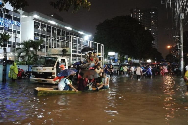
- Last year, the country experienced a volcanic eruption, a series of major earthquakes, and successive typhoons that inundated more than 60 towns and cities.
- Knowing the country’s vulnerability level to disasters, various government agencies rolled out a series of apps to aid local government officials in crafting local solutions to these disasters.
- These solutions are based on the National Exposure Database (NED), a platform that collates data to aid in policymaking.
MANILA — For the Philippines, the COVID-19 pandemic wasn’t the only disaster to hit the country in 2020. The year started out with a volcanic eruption and closed with two magnitude 6 earthquakes, one of them striking on Christmas morning. In between came Typhoon Goni, a late-season superstorm that was the strongest in the world last year.
At least 60% of the country’s total land area, nearly 300,000 square kilometers (116,000 square miles), is vulnerable to natural hazards, in large part due to the archipelago’s location along both the path of the tropical storms brewing in the western Pacific and the Ring of Fire.
Around 74% of its population of more than 100 million is subject to various impacts from these disasters, and the country routinely ranks among the top 10 natural disaster-prone countries in the world, according to the World Risk Index.
Mitigation efforts depend on a network of early-warning systems that are constantly being fine-tuned, and on establishing mechanisms to respond more quickly to natural disasters.
The latest shot of help comes from the National Exposure Database (NED), which identifies vulnerable areas so agencies and local governments can come up with real-time analyses and craft swift responses during a disaster. It also helps in planning and implementing disaster-ready solutions.
Gathering the data …
The NED’s primary tool for data collection and updates is GeoMapperPH, a web and mobile application that collates hazard, exposure, vulnerability, and coping capacity data from across the country. Launched last July, GeoMapperPH was developed by various government agencies led by the Philippine Institute of Volcanology and Seismology (PHIVOLCS).
Built around a geographic information system (GIS) core, it aids in disaster prevention and mitigation by tapping the databases of at least 53 municipal governments, six national government agencies, and three NGOs.
Users, limited for now to government entities and accredited NGOs, can input information in real-time, and access the information of other users to get a more comprehensive analysis of disaster-related concerns relative to their location.
Field surveyors can use the application offline and sync their data to the system once they’re online.
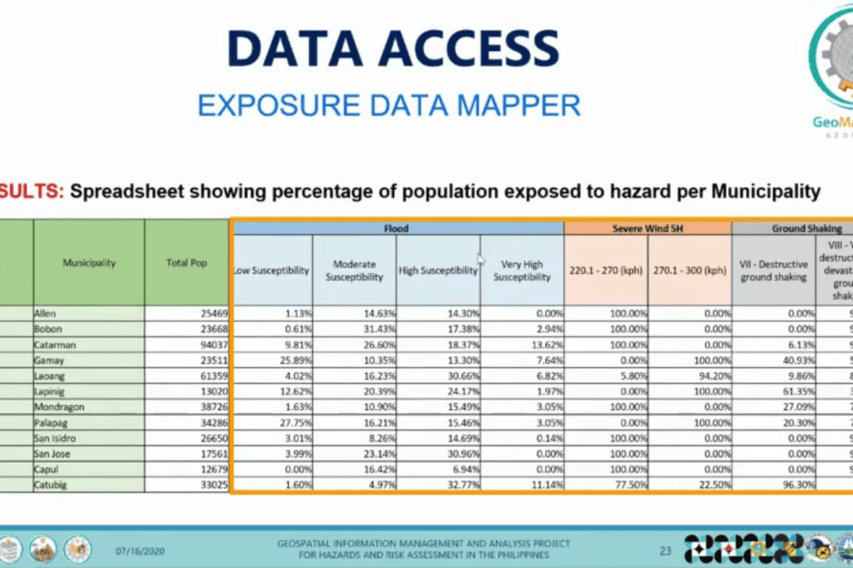
By feeding in information such as building location, structure, and vulnerability, and combining it with data input from the national volcano and weather bureaus, the system can generate automatic identification of natural hazard susceptibility. This enables local officials to see what percentage of the population would be exposed to ground shaking, severe wind, or flooding in any given municipality.
Such exposure data are key in disaster response, rehabilitation, zoning and planning. Knowing natural hazard susceptibility in neighboring areas would also help in disaster management. Additional inputs come in the form of automatically generated geocodes from data of the Philippine Statistics Authority and automatic identification of elevation and distance from the coast using data from the National Mapping and Resource Information Authority’s interferometric synthetic aperture radar.
… And putting it to use!
In terms of disaster preparedness, local governments can use GeoMapperPH to create evacuation routes, develop evacuation centers, and situate public facilities far from danger-prone areas.
The GIS-based tool, known as “GeoMapperPH: Situation Data Mapper,” is especially critical during the onslaught of a natural disaster. It monitors the situation on the ground during calamities and feeds an awareness information dashboard that can be used for a more accurate impact assessment in a specified area.

The dashboard was in use during the eruption of the Taal volcano at the start of 2020. It showed the affected population per city or municipality and estimated the cost of damage to agriculture of at least 3.21 billion pesos ($66 million). Knowing exact figures, such as the number of affected families currently in evacuation centers, puts a face to the data and aids in prioritizing help for more devastated areas.
As for disaster rehabilitation and recovery, local governments are able to decide on the disbursements for affected areas based on the financial impacts of the disaster as indicated in the NED and determined with the help of GeoMapperPH.
Not just a planning tool
Although GeoMapperPH was created primarily for disaster management, it can be used for a much wider range of applications associated with geolocation, said Renato Solidum Jr., undersecretary of the Department of Science and Technology and head of PHIVOLCS, the volcano bureau.
“GeoMapperPH is a tool to capture data, not only location, but other relevant information so that this can be integrated into a platform,” he told Mongabay.
The geospatial database created by GeoMapperPH is powerful because the location points can feature not only quantitative details like measurements of areas and perimeters, but also qualitative information like the age of a structure, building materials, type of ground soil, population, and so on, Solidum said.
“Essentially, the geospatial information is crucial to any planning effort, monitoring, or impact assessment whether it be for disasters or environmental purposes or even for economic planning,” he said.
Some examples of how GeoMapperPH can be used, he said, including as a monitoring tool to check on the status of a tree-planting initiative or to look into areas with pollution as captured by satellite images.
“The traditional way of looking at data or statistics is by the table. But now, the trend is for every point on the ground, you can put any statistical information relative to that point,” Solidum said.
The GeoMapperPH team guides the platform’s users by providing orientation classes, training, and consultations. Government agencies, local authorities, and NGOs can also request assistance with database analytics as well as the personalization of dashboards depending on their needs.
Other GeoMapperPH users include the Office of Civil Defense, Rapid Earthquake Damage Assessment System of PHIVOLCS, School Locator of the Department of Education, and Health Facility Mapper of the Department of Health.
Mapping the Earth to save it
The Department of Environment and Natural Resources has its own GIS already. Solidum said it was among the first government agencies to reach out to him regarding the use of GeoMapperPH for climate information services.
PHIVOLCS senior science research specialist Mabelline Cahulogan told Mongabay that GeoMapperPH can also be used to support environmental protection efforts.

“GeoMapperPH may help with proper environmental resource allocation and deployment,” she said, adding that “proper easement from bodies of water may be determined and visually, decision-makers may pin down areas that need to be cleared and areas that may still be inhabited.”
Moreover, using the GeoMapper to build on the NED can contribute greatly to the decision-making process on sustainable development. According to Cahulogan, the NED would help ensure that physical framework plans, comprehensive land use plans, and other disaster-related policies can be formulated more efficiently.
In terms of land use and building use, there would be greater ease of doing business and increased transparency due to the data sharing enabled in the application.
The need for good governance
GeoMapperPH is part of the Geospatial Information Management and Analysis Project for Hazards and Risk Assessment in the Philippines (GeoRiskPH).
Established in 2018, GeoRiskPH includes two publicly available platforms: HazardHunterPH for location-specific initial hazard assessments, and GeoAnalyticsPH for summaries of hazard and risk assessments, analysis, and visualization.
Thanks to the GeoRiskPH initiative, PHIVOLCS received the Special Achievement in GIS (SAG) Award in 2020 from Esri, the developer behind the ArcGIS mapping platform that undergirds GeoRiskPH.

For Solidum, the rollout of the three GeoRiskPH applications is not just due to the technical expertise and dedication of the individuals involved in the initiative. “We have to understand that the solution to a particular problem is not simply technology,” he said. “The tool is the technology, but governance would now enter the picture because the data and technology are there, but to convince organizations to engage is a different matter.”
He pointed to the problem of bureaucracy experienced in all countries and said his team had surmounted it by gaining the government’s support. “If you don’t have good governance, then it will fail,” he said.
Regional use of geospatial tech
While the rollouts and operations of GeoMapperPH, HazardHunterPH, and GeoAnalyticsPH have been smooth sailing, the GeoRiskPH team is still at work because the applications are ever-evolving platforms. The work doesn’t stop once data is encoded and a visualization map is generated because things can change overnight or in an instant.
And with his hands full due to the current developments and improvements in the GeoRiskPH platforms, Solidum said he aims for greater location intelligence efforts in the Philippines.

The GeoMapperPH team is looking to incrementally scale up the involvement of other government agencies, local governments, and NGOs in the initiative. Solidum said his team has been working to this end with the Department of Public Works and Highways.
The Philippines is looking to espouse location intelligence internationally by sharing its best practices and creating a program similar to GeoRiskPH. Solidum heads another Department of Science and Technology geospatial technology program, this time involving other Southeast Asian nations. Proposed before the COVID-19 pandemic, the initiative aims to develop a science and technology innovation platform for disaster resilience across the region.
These countries share many of the same disaster risks as the Philippines due to their geographic location, and Solidum and his team said they hope to replicate their local geospatial analysis efforts to assist the Southeast Asian region in becoming more resilient in the face of disaster.
Related stories:
Banner image of the Taal volcano, on Alert Level 2 warning on February 28, 2020. The volcano erupted at the beginning of the year. Photo by Ray in Manila via Wikimedia Commons
FEEDBACK: Use this form to send a message to the author of this post. If you want to post a public comment, you can do that at the bottom of the page.