- Greg Asner started creating CLASlite during grad school in 1997, and by 2005 was using the satellite-image processing platform to monitor the entire Brazilian Amazon.
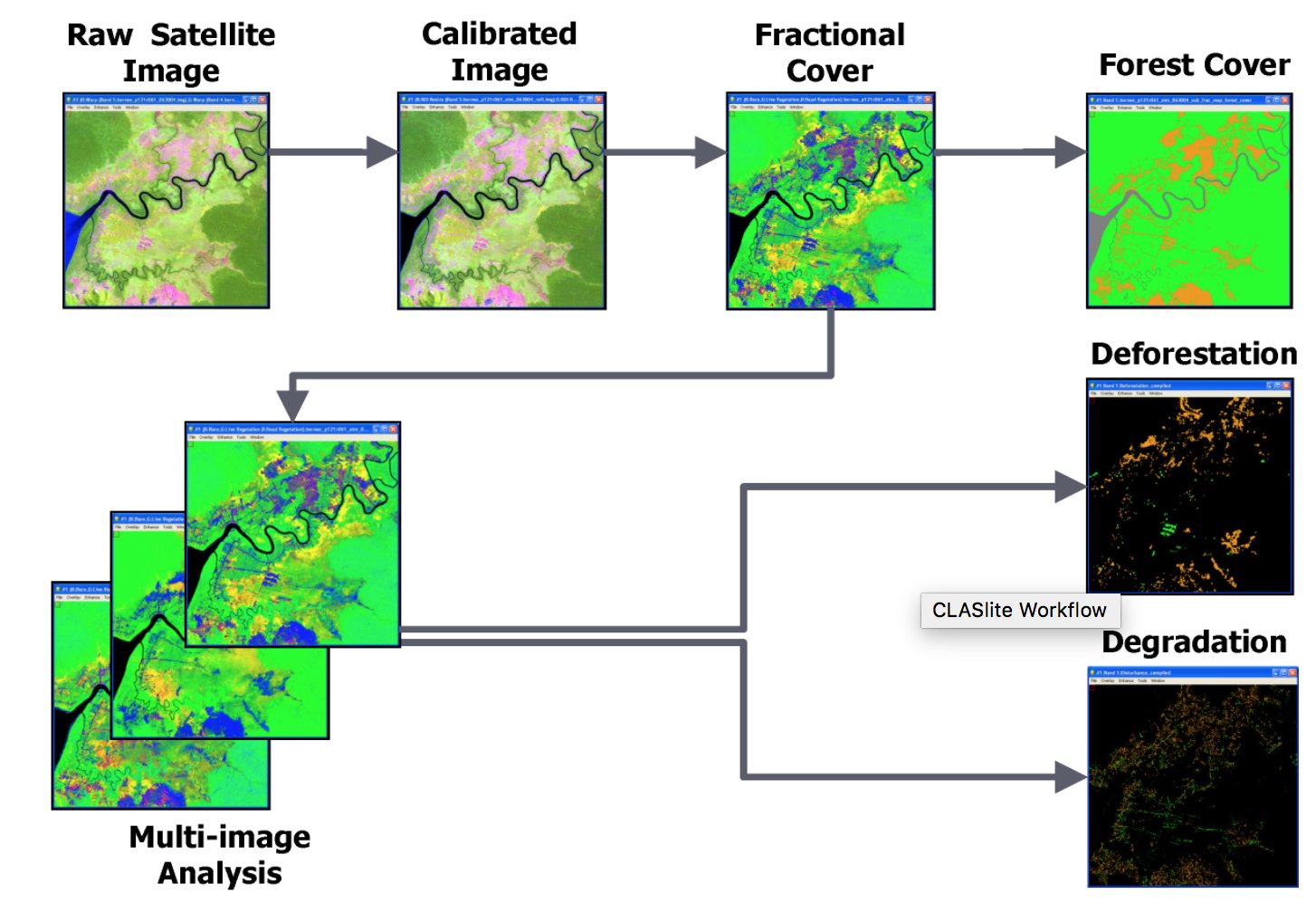
- The application automates the workflow for rendering satellite images into useful, information-rich maps to track logging, deforestation, and other forest disturbance events.
- Asner recently joined forces with Rajnish Khanna of i-Cultiver to create a low-cost, user-funded model to keep the CLASlite software running and accessible.
- In an interview, Anser tells Mongabay about the platform that he calls “the fastest and easiest way to take a look at any forest from Earth’s orbit.”
Satellites are an excellent tool for monitoring forests. Those who work in the areas of forest management, policy development and environmental conservation are increasingly making use of these eyes in the sky to track logging, deforestation, and other forest disturbance events.
However, it takes specialized tools to turn the green blur of raw satellite images into useful information. Enter CLASlite, an automated system for converting satellite imagery from its raw format into detailed maps that can be searched for specific forest disturbance events. CLASlite aims to make deforestation and forest degradation monitoring accessible to everyone.
“CLASlite is, without a doubt, the fastest and easiest way to take a look at any forest from Earth’s orbit,” Greg Asner, CLASlite’s creator and director of Arizona State University’s Center for Global Discovery and Conservation Science, told Mongabay.
CLASlite is wide-ranging in its application. For example, it has been used to promote forest stewardship and predict land-use change in the Amazon, to examine the effects of oil palm plantation development on land cover and carbon flux in Indonesian Borneo; and to determine the spatial drivers of deforestation in Suriname.
Asner, who recently joined forces with Rajnish Khanna of i-cultiver to create a low-cost, user-funded model to keep the CLASlite software running and accessible, spoke with Mongabay about the application and recent changes to the project.

Mongabay: What is the function of CLASlite? What can it offer that is unique from other forest monitoring platforms?
Greg Asner: I created CLASlite for the purpose of making deforestation and forest degradation monitoring possible accessible and operable by non-experts. I started creating CLASlite in 1997 in graduate school, and by 2005, I was monitoring the entire Brazilian Amazon at high resolution. By 2008, my team and I had simplified the system to a software package that others could use. And by 2014, we did a big rollout to support a global community. CLASlite remains the only software package in the world that allows a user to monitor forests from their own desktop. No other approaches are available from any source I know of. [See Satellites and psychology for improved forest monitoring.]
What are some notable examples of projects that have used CLASlite?
The first really big use was when I mapped forest degradation throughout the Brazilian Amazon, which I reported in Science in 2005. Since then, the CLASlite community has grown and has mapped forests in more than 120 countries. Governments, NGOs and academic institutions are the main users of CLASlite. [See success stories from the CLASlite community.]
Can you tell us about any exciting ongoing or upcoming projects?
It’s hard to keep up with all of the organizations using CLASlite. We use it to monitor tropical forests worldwide, but it works on any forest, not just tropical forests.

Can you tell me more about the transition CLASlite has recently undergone to a low-cost, user-funded model?
After 20 years of me keeping CLASlite alive by writing proposals to cover the cost of software updates, it became harder and harder to find support from donors. So I decided to combine forces with the folks from i-Cultiver.com to help keep it going. They are providing the service of licensing and software updates for a small fee to users. By distributing the cost to all users, we think the cost can continue to be kept minimal. The more people we have pitching in, the more likely it is that CLASlite will continue at low cost. You can see what we are doing on our new claslite.org website.
You offer a free forest monitoring with CLASlite course. What is the aim of this course and who do you hope to reach?
I launched the course in 2014 to provide free training, not only on how to use CLASlite, but more generally, how to do forest mapping. I launched it at Stanford, where I was a professor at the time, and thankfully, Stanford continues to support the course for the global community of users and potential users of the concepts and software behind CLASlite.
This new platform launched in the midst of the COVID-19 pandemic, so perhaps it’s too soon to ask this question, but have you seen any indication of a change in usage during the crisis?
We haven’t seen anyone report on whether COVID-19 has impacted forest losses or other changes, but CLASlite is, without a doubt, the fastest and easiest way to take a look at any forest from Earth’s orbit.
Anything else you would like our readers to know?
I’m the director of the ASU Center for Global Discovery and Conservation Science based in Tempe, AZ, and Hilo, HI. CLASlite is no longer maintained in my lab, but we continue to be major users of it, and I hope others will join the CLASlite community.
Banner image of CLASlite map courtesy of Greg Asner.
FEEDBACK: Use this form to send a message to the author of this post. If you want to post a public comment, you can do that at the bottom of the page.