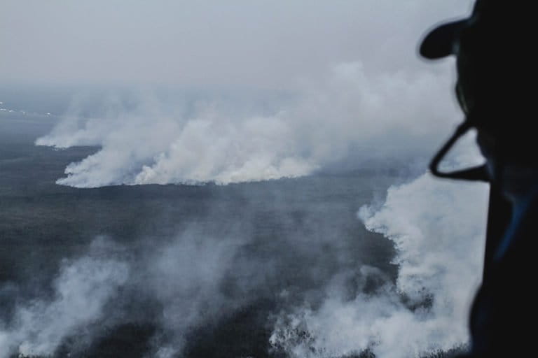
- Aerial images taken last month in the southern part of Indonesia’s Sumatra Island show fires raging through peatlands and generating massive clouds of haze.
- The fires this year are the worst since 2015, exacerbated by an unusually intense dry season and an El Niño weather pattern.
- The fires are set deliberately to clear land for oil palm and pulpwood plantations, and the smoke they generate has sickened hundreds of thousands of people and spread as far as neighboring Singapore and Malaysia.
PALEMBANG, Indonesia — Aerial images taken last month in the southern part of Indonesia’s Sumatra Island show wildfires burning through peat forests and producing clouds of toxic smoke.
Peatlands in the districts of Ogan Komering Ilir and Ogan Ilir in South Sumatra province were among those pictured ablaze by Mongabay Indonesia’s Nopri Ismi, who joined a water-bombing flight by the local disaster management agency, or BPBD, on Oct. 24. The air quality index for both districts hit unhealthy levels that day, according to the data from the Indonesian environment ministry.
Experts earlier this year warned of an exacerbated fire risk as a result of an intense dry season and El Niño weather pattern. Observers expect this year’s fires to be the worst since 2015, when similar conditions led to the razing of more than 20,000 square kilometers (7,700 square miles) of land, much of it peat forest. The fires are deliberately set to clear land for oil palm and pulpwood plantations, and the smoke they generate has sickened hundreds of thousands of people and spread as far as neighboring Singapore and Malaysia.
In the wake of the 2015 fires, the Indonesian government rolled out a series of regulations and efforts to protect intact peat and rehabilitate burned lands, including the establishment of a Peat Restoration Agency (BRG). In South Sumatra province, the agency has carried out restoration programs in the districts of Ogan Komering Ilir, Banyuasin, Musi Banyuasin, Muara Enim, and Musi Rawas.
But fires have still flared up on peatlands across the province this year. In June, South Sumatra Governor Herman Deru was widely ridiculed after telling local media that the fires were likely started by sunlight reflecting off car windshields or by friction between tree branches.

Ogan Komering Ilir
Nearly half of Cengal subdistrict, which spans a little over 2,400 square kilometers (925 square miles), is peatland. Much of the peat area has been razed for oil palm and pulpwood plantations. On Oct. 24, fires were spotted on parts of these peatlands.
There have been no government-led peat restoration efforts in Cengal, according to Mongabay Indonesia’s findings, despite it being an extensive peatland.
The peat swamp served as a site of a key port during the Sriwijaya Empire up until the 12th century, and in the wake of the 2015 fires people flocked here in search of historical objects that may have been unearthed by the flames.
The BPBD flight also went over the peatlands in nearby Pedamaran subdistrict. As with Cengal and other subdistricts here, much of the peatland in Pedamaran has been allocated for oil palm plantations, including in the Sepucuk area that President Joko Widodo visited during the 2015 fires. Several peat restoration projects have been carried out here, including digging water canals and wells to rewet the peat that had been drained for planting. Yet fires were still visible on the day the BPBD team flew over the area.


Ogan Ilir
Much of Ogan Ilir, which covers 2,500 square kilometers (970 square miles), is peat swamp, and fires and haze are an almost annual phenomenon here. Yet the district isn’t included on the list of sites for peat rehabilitation by the Peat Restoration Agency.
Much of the peatlands across the district have been licenses out for oil palm plantations and other agriculture. The subdistricts of Inderalaya and Pemulutan have registered the highest number of fire hotspots this year.


This story was first reported by Mongabay’s Indonesia team and published here on our Indonesian site on Oct. 27, 2019.
FEEDBACK: Use this form to send a message to the author of this post. If you want to post a public comment, you can do that at the bottom of the page.