
- The government of Penang, Malaysia, has big plans to upgrade the state’s transport system via a new network of highways, bridges, tunnels and rail lines.
- While many are hopeful the new roads will ease the island’s infamous traffic, conservationists are concerned that the plan will lock Penang into a car-oriented future.
- One highway project has already been hit by a deadly landslide, adding to residents’ concerns.
Traffic is a decades-old problem in Penang, a common complaint shared across class, race and political lines in this Malaysian state. When it’s brought up, Siti Fadhilah, a 31-year-old selling roti flatbread in Penang’s Paya Terubong town, grows exasperated: taking her young son to school can take up to an hour.
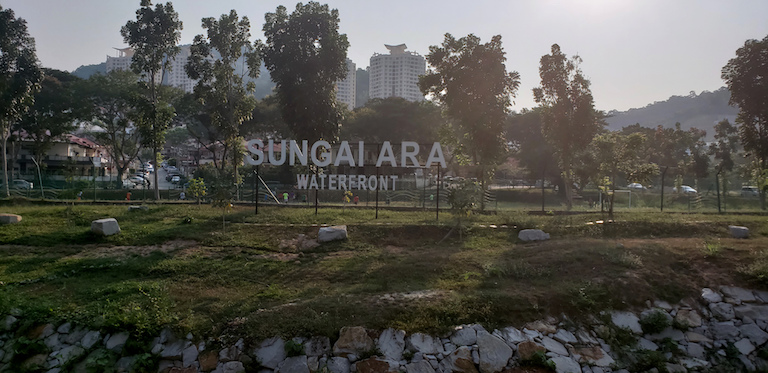
The outlandish jams aren’t the only recent changes to her town, sandwiched within the hilly center of Penang Island, 4 kilometers (2.5 miles) west of peninsular Malaysia. Just next to the cluster of aging high rises where Siti lives and works, excavators bite into the hills to build gleaming new condos and another highway. She notes that flood season is growing more unmanageable with construction — dirtying the neighborhood, forcing her to close shop. And after a deadly landslide hit another highway construction site in Paya Terubong last year, residents are mindful of the potential dangers of the upcoming highway development, which will cut through hills on the opposite side of the valley. But overall, she’s looking forward to the coming highway, hoping it will temper the absurd commute for the whole 293-square-kilometer (113-square-mile) island.
“I think [the new highway] is a very good thing, because we all want less jams,” she said.
Construction of this highway — the north-south Pan Island Link 1 (PIL1) spanning a total 19.5 kilometers (12.1 miles) — will begin next year, a first project in an ambitious scheme to restructure transportation and ameliorate traffic on the island. However, civil society and watchdog groups worry PIL1 and the other projects within the Penang Transport Master Plan (PTMP) will not increase public transportation use and, at worst, irreparably damage hills and natural resources on the fast-developing island.

All part of the master plan
The completed transportation plan would drastically change the shape of the island, literally raising much of the traffic via elevated transit routes, highways tunneling through Penang’s hills, and even a monorail.
With this master plan, Penang is racing to keep up with Malaysia’s next-level developments, as the country builds infrastructure, residences and luxury properties to fit in among Asia’s high-income economies. At the same time, citizens are steadily becoming aware of the environmental degradation that comes with rapid development and are starting to speak out.
It will be more than a decade before the entire vision for Penang can be realized, but two key pieces of the plan received approval to start next year: the first phase of the PIL1 and the Bayan Lepas light rapid transit (LRT). These two routes run parallel, with the road passing through Penang’s hills and the light rail cutting through the island’s urbanized east coast.
The state government has deliberated transportation infrastructure projects since 2008, and in 2015 officials accepted a plan from SRS Consortium, a group comprised of the infrastructure engineering company Gamuda and two Penang-based property developers, Ideal Property Development and Loh Phoy Yen Holdings. Completing the first phases of the PIL1 and the LRT is expected to cost at least 16 billion ringgit ($4 billion), with the whole project currently estimated at 46 billion ringgit ($11.5 billion).
Operating on a shoestring development budget of just 306.4 million ringgit ($76.6 million) this year, the government aims to fund the entire project by reclaiming three islands, a total of 18.2 square kilometers (7 square miles), south of Penang Island and selling the land to developers. That reclamation is reportedly projected to bring in 70 billion ringgit ($17.5 billion) in land sales, though it’s mired in controversy: the federal planning commission previously rejected the plan due to incomplete impact assessments, and Penang fisherfolk balk at the idea of another reclamation they fear would contaminate their catches and limit water use.
The reclamation has not yet been approved, but its EIA, released this month, indicates an intensive process requiring developers to dredge an estimated 189.1 million cubic meters (6.7 billion cubic feet) of material from off the coast of Malaysia’s Perak province. It will likely affect fisheries, coral reefs and turtle nesting, which have already struggled to adapt to developments along Penang’s southern coast.
When the government started considering ways to address traffic in the state in 2008, civil society actors were enthusiastic and felt they could suggest ideas and feedback, says Lim Mah Hui, a retired banker and professor and former city councilor. Lim feels the conversation changed, moving from encouraging increased public transport use to planning to build up Penang further.
“At the rhetoric level, you can’t argue too much against it, because they’re saying the right things – you want to a have family oriented city, you want to be green, you want to have smart [planning],” he said. But he feels the projects in this plan don’t truly reflect the ideals they used to promote the master plan.
Tunneling toward trouble
More than half of the proposed 19.5-kilometer highway will tunnel through the island’s hilly core, skirting around Penang’s east coast, which bursts with new developments.
The PIL1 will start at Gurney in the north and cut south through the central part of the island, passing into the hills via a drill-and-blast route, before rejoining the Bayan Lepas free-trade zone. According to its environmental impact assessment, the route will cut through 234 properties — houses and squatter houses, religious sites and nearly 4 hectares (10 acres) of the public Youth Park — and run very close to two sensitive sites, the Kek Lok Si Buddhist temple and Air Itam Dam. The Penang Structure Plan 2020, which sets out the state’s classification of land types and uses, bars development of land at an elevation higher than 76 meters (250 feet) above sea level and/or 25 degrees in gradient, with an exception for “special projects” like this highway.
To Kam Suan Pheng, a soil expert and member of the civil society coalition Penang Forum, there are several alarming aspects revealed in the EIA: she says the document failed to include assessment of alternative routes, and that several lapses in the planning indicate an oversight on the government’s part.
For example, the plan originally required more than six berms, or terracing built into manmade slopes for erosion mitigation. To minimize the risks of landslides, Malaysian hillside development guidelines do not allow developers to create slopes that need more than six berms. But at one instance the PIL1 design required 29 berms, said Khoo Salma Nasution, vice director of the Penang Heritage Foundation and a prolific author on Penang history and culture. In response, an engineer for the Penang State Economic Planning Division, Roy Mithran, says the publicly released EIA is just an initial document and that more detailed plans from the SRS Consortium will be released before they break ground.
The ground itself hides hazards. The EIA highlighted three places where the blasting will cross fault zones where the rock underlying the hills is weak, but only calculates the associated risks on a two-dimensional vertical view, not the three-dimensional space that fault zones occupy, Kam notes. There’s an increased risk of water contamination along fault zones in weathered granite terrains like the Penang Hills, she says, as tunneling may cause more cracks in the weathered granite and thus increase the likelihood of groundwater contamination.
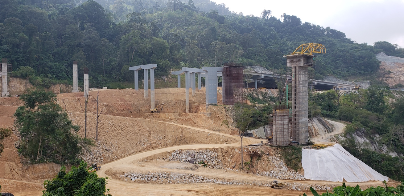
Penang’s hillside construction site turned to a deadly force just a few months ago: a landslide broke on Oct. 19 at the Bukit Kukus road construction site in Paya Terubong, one of the island’s densest towns, killing nine foreign workers. The site reopened at the beginning of this year; now the town is bracing for construction of the PIL1 on the opposite hillside.
Geotechnical surveys of the Paya Terubong area from 2006 have shown the land is highly susceptible to “deep” landslides that involve further layers of rock, and therefore cause greater damage. Even if the drilling for PIL1 proceeds without issue, Rexy Prakash Chacko, co-founder of Penang Hills Watch, worries that departments in the state government are not working together to identify erosion risk sites, which was deemed a factor causing the landslide last year.
“Since the 1990s, lots of rockfalls and landslides happened there, and also many landslides, but no one took notice of them” because there were no major casualties, Chacko said.
“It all passed under the table until the Bukit Kukus landslide actually happened.”
Reducing traffic in the long term?
Perhaps the biggest upset to civil society and environmental monitors is that the government originally made efforts at sustainability but does not appear to be following through with the current plan.
Years before the current PTMP emerged, the state commissioned international planning consultancy Halcrow (now known as Jacobs) to add small segments of new highway but also reduce vehicle usage. The plan sought to revitalize existing public transportation and encourage walking and cycling.
To civil society, those low-cost, minimalist approaches to mitigating traffic seem to have been completely discarded in today’s PTMP.
Mithran, the state engineer, said that similar efforts will be part of a fifth and final component of the master plan, grouped into an “Institutional Plan,” which the government won’t develop until the infrastructure projects are complete.
At last estimates in its EIA, the PIL1 will carry between 18 and 30 percent of traffic moving north to south. The LRT assessment did not yet estimate how much vehicle traffic it might absorb, though the state’s chief minister says it will move the country on track to reach its 50-year-goal of having 40 percent of commuters use public transport.
But if Penang Island wants to accommodate the growth of traffic in the more distant future, it will need to create that space in the hills before another developer uses it for something else, Mithran said. “You have to freeze the corridor for future use, otherwise someone might build the corridor for future use.”
Even if the development proceeds without issue, members of the civil society coalition Penang Forum believe the first phase of developments won’t meet their goal of increasing the rate of public transportation use. Khoo, the heritage advocate and author, says she believes the state’s ridership goals — 42 million riders annually — does not reflect the habits an island of nearly 800,000 people, even if the population surpasses 1 million in 2030.
“I guess we all have to do our national duty and line up at the LRT every day for them to achieve that kind of ridership,” Khoo said.
Chief Minister Chow Kong Yeow, defended the project, saying the highway is one component of the better road network needed to boost mobility in Penang.
“The concerns that PIL1 will not boost public transport usage is only a misconception from lack of understanding of the philosophy behind PTMP,” Chow wrote in a statement.

Before the SRS Consortium plan was on the table, civil society discussed improvement to existing bus and ferry systems, but according to citizen journalist and activist Anil Netto, the opposition party state leaders said they couldn’t get approval from the federal government.
Now that Penang’s Development Action Party is part of the Pakatan Harapan coalition that gained federal control in 2018, local officials should be able to lobby for better buses and ferries. But they have not yet made that push, Netto says. “My theory is all this is too cheap. The whole idea is to reclaim land.”
In a written statement, Yap said that environmental risks will be assessed at every phase of the PTMP’s multiple projects, and proper slope management will be used to reduce risks of landslides, which turned deadly in 2017 and 2018. “There is no necessity [to] compare and contrast two dissimilar projects,” she wrote.
This has not assuaged the fears of Kam, the soil expert. She pulls out a picture of the 2018 landslide in Paya Terubong, just around the corner from Siti’s shop and the affordable housing developments, and notes the chunks of land that eroded. The signs of gully erosion were noticeable for months before falling as they did in October, and she says a knowledgeable geotechnical expert could have caught the warnings if there had been proper monitoring. Without a fleet of geotechnical experts who could spot the signs at Bukit Kukus, Kam says she fears the blasting and drilling of a new highway will once again endanger Paya Terubong and the rest of the island’s hillside communities.
“If you don’t have that kind of capacity,” she says, “should you be pursuing these kinds of projects that you cannot monitor and you cannot afford?”
Correction: A quote originally attributed to a spokesperson for Chief Minister Chow Kong Yeow has been corrected to be attributed directly to the minister. Khoo Salma Nasution’s title has also been corrected.
Banner image: The construction site of the Bukit Kukus “paired road.” Image by Danielle Keeton-Olsen for Mongabay.
FEEDBACK: Use this form to send a message to the author of this post. If you want to post a public comment, you can do that at the bottom of the page.