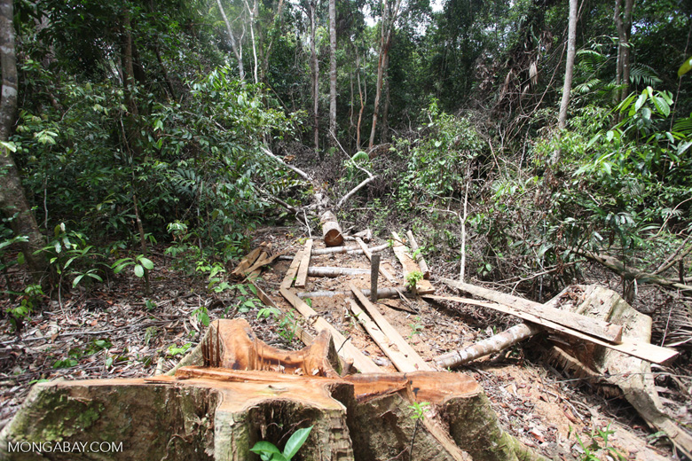
- Researchers used images from LiDAR, a remote sensing technique that produces 3-D depictions of forest structure, to map logging areas—including roads, skid trails, gaps under the canopy, and decks used to store timber—for four timber concessions in Kalimantan on the island of Borneo.
- Pairing the LiDAR data with statistics on the number of trees felled and damaged, the researchers established equations relating the logging area data to both the volume of timber harvested and the resulting greenhouse gas emissions.
- The equations explained up to 87 percent of the variation in the volume of timber extracted.
- Using this method, governments, NGOs, and private organizations can verify timber harvests, formulate future management plans, and estimate harvest volumes and greenhouse gas emissions in other tropical forests, including areas of illegal logging.
Selective logging—where specific high-value trees are cut—in tropical forests affects biodiversity, forest structure, and carbon storage. According to a 2009 study, timber was removed from over 20 percent of the area of humid tropical forests during the 2000s. Notably, more than half of the greenhouse gas (GHG) emissions from forest degradation in the tropics have come from selective timber harvests.
Forest laws determine the areas, volumes, and maximum and minimum diameters of trees that can be extracted from a concession in any given year. Unlike forest clearing, selective logging is not easily quantified using satellite imagery.
Most previous logging estimates rely on data from governments and timber companies, which are not independent and do not include illegal logging, for which there are few reliable, globally consistent assessments. Research suggests that illegal logging accounts for roughly 40 percent of all logging in the tropics, with figures as high as 72 percent for the Amazon.
Now, a pair of studies present a method using models to detect selective logging areas and estimate volumes of timber harvested, both legal and illegal, along with the resulting GHG emissions, from high-resolution aerial images. Relating forest structure from the images with timber harvest volumes and GHG emissions, the researchers state, enables future studies to deduce harvest volumes elsewhere from remote sensing alone.
“Those wanting to know greenhouse gas emissions finally have an independent means to examine the impact of timber harvesting,” said Timothy Pearson, director of Arkansas-based non-profit Winrock International’s Ecosystem Services, and lead author of the study.
Peering under the canopy through LiDAR
Traditional moderate-resolution (30-meter) satellite imagery can be ineffective at detecting a group of trees plucked out from the dense forest canopy by poachers. Resolutions greater than 1 meter can capture primary logging roads, the researchers state in their paper, but not skid trails created beneath the canopy by dragging logs or gaps exposed in the canopy by felled logs. Even high-resolution (1m) satellite images cannot peer through the canopy, where most of the damage from selective logging occurs.
So how can we independently determine how much selective logging has occurred?
Researchers have turned to aerial surveys that use LiDAR (Light Detection And Ranging), a remote sensing method that measures the return time of many thousands of pulsed laser beams sent to Earth’s surface from an aircraft. The return time of each pulse represents its distance from the airborne sensor. Some pulses penetrate the canopy, enabling scientists to generate high-resolution (sub-1 meter) three-dimensional images from the ground to top of the canopy and detect changes inside the forest.

“What LiDAR allows us to do is not just see the canopy but also look underneath so we can see pockets and tunnels that are caused by the timber extraction,” said Pearson and co-author Stephen Hagen, a senior scientist at Applied GeoSolutions.
Looking beneath the forest canopy is “really important for logging because when you are just removing a few trees you sometimes cause minimal damage to the canopy,” Pearson and Hagen said.
For example, gaps created above the stump of a felled tree may be smaller than the tree’s crown, and branches from surrounding trees will partially cover where the felled tree stood.
With LiDAR, we “don’t have to rely on being granted access to areas by companies or governments,” stressed Hagen.
Pairing of LiDAR data with field data to estimate harvest volumes and emissions
A team of researchers, including Pearson and Hagen, recently developed automated algorithms based on commercial LiDAR data from Kalimantan, the Indonesian portion of Borneo, that can detect and generate fine-scale 3D maps of logging roads, skid trails, gaps, and decks used to store the logs.

For the current study, funded by NASA’s Carbon Monitoring System, the team paired these maps with ground data on 188 trees cut from two logging concessions, Roda Mas and Timberdana.
By pairing the LiDAR data with the known extracted timber, the researchers gleaned relationships between the roads, skid trails, and gaps and the volumes of timber extracted and formulated equations to estimate harvest volumes elsewhere based solely on remotely sensed LiDAR data.
In addition, the team linked the volumes extracted with emissions factors to calculate the resulting GHG emissions. These factors included emissions arising from the 963 trees damaged incidentally (i.e. snapped or uprooted) during felling, storage, and extraction of the timber.

Relating forest structure to timber extraction
They developed three equations to estimate the volume of timber harvests and GHG emissions from the LiDAR data under different scenarios. The first equation, includes roads, gaps, and skid trails as predictors, and explained 87 percent of the variation in volume of timber extracted. According to Pearson, “that is a very strong relationship for an equation to have that much predictive power.”
Damage caused by logging generated greater emissions in both concessions than either log extraction or infrastructure. Because the emissions factors were similar in both concessions, they combined them to allow for extrapolation to other concessions.
When the researchers used the equation to calculate the volumes of timber extracted from the two surveyed concessions, Roda Mas and Timberdana, their estimates (59,452m3) were similar to the actual reported volumes (60,827m3).
Next, they applied the equation to two other concessions for which LiDAR data were available but ground data were not. Sari Bumi Kasuma emerged with the highest carbon dioxide emissions, while Roda Mas came second. But per hectare, Timberdana had the highest rate of emissions, followed by Roda Mas.

A second equation was developed to estimate the volume of illegal logging where rivers, instead of roads, are used to extract timber. As a result, roads data were omitted from the equation, which still explained 86 percent of the variation in the timber harvest data.
But what happens when both on-the-ground data and LiDAR are unavailable? Since LiDAR data are costly to obtain, the team created a third equation that considered only road length, which they found could predict 78 percent of the variation in the timber volume. Road lengths can be obtained from freely-available moderate resolution imagery.

The case of illegal logging
Pearson explained that there are two types of illegal logging. The first occurs within legal concessions when “timber is extracted outside the area of the granted concession or goes beyond the maximum area that can be harvested in a given year or too many trees are extracted from the allowed area.” All three equations can be used for this case, he said, “but if only moderate resolution satellite data are available, the road equation could be used.”
In the second type of illegal logging scenario, operators extract high-value trees from pristine or protected forests. “In this case,” Pearson said, “it would be very rare for roads to be built.” Instead, these logs are extracted by floating them out on rivers. Consequently, the second equation, based on only gap areas and skid trails, would be suitable to estimate the volume of extraction.
Using the airborne LiDAR maps, the team identified an illegal logging site in Central Kalimantan, located outside of the concessions, which lacked roads and consisted only of skid trails and logging gaps. By applying the second equation, they estimated 730m3 of timber harvested (20 m3 per hectare) resulting in emissions of 45 tons of carbon dioxide equivalents per hectare, roughly half of the average rate of emissions of the legal concessions. They believe that relatively smaller trees harvested might explain the lower volumes and emissions.
Using the approach to estimate logging in other areas
The method can be applied to other upland forests in Kalimantan, whereas swamp forests have a different structure, leading to different relationships, said Pearson and Hagen.
Application to tropical forests elsewhere will require both LiDAR and field data to create relationships. “It will be interesting going forward to examine how much the relationships vary in different forests and if there are patterns that will allow us to predict relationships for forests we haven’t visited,” they added.
“We know for example that the Indonesia sites use bulldozers to skid the logs out of the forest, while many other logging operations use skidders, which have a smaller footprint,” Pearson noted.

The researchers suggested that governments can use the approach to independently monitor concessionaires’ adherence to harvesting plans and apply appropriate taxes. Buyers, investors, and non-governmental organizations can use the approach to independently verify harvests to guide future management actions. Emissions data on timber harvests could inform countries’ commitments to international climate change and REDD+ programs.
Limitations of the method
One of the main downsides of the method is the high cost of obtaining LiDAR data, which usually limits data collection to a single set of overflights, said Michael Palace, associate professor at the University of New Hampshire, who was involved in the earlier automated algorithms study. Moreover, flying may be restricted in some areas.
Apart from obtaining LiDAR images, there is the cost of collecting field data that links the forest structure variables to timber volumes and emissions, explained Pearson. However, he said, “the cost of collecting data in the field on an ongoing basis (let alone the issues of access) will make a remote method cost-effective, and where application is broad, this potentially would even cover the initial development costs.”
“Ultimately, relationships could be created for all relevant regions, at which point the new imagery would be all that is needed,” he envisioned.
Estimating timber volumes and emissions in areas without LiDAR flight data still requires field sampling, which can be even more costly than LiDAR over the long term. If timber harvest volumes can be estimated using remote sensing and equations, which can be done in hours, versus days, it can save time and money. Remote sensing can cover any area of land, eliminating the need for permission to visit a site and measure wood of logged trees, thereby offering a way to monitor illegal logging.
Like other methods, estimation with LiDAR data paired with equations derived from ground data also has uncertainties, Pearson and Hagen said, but for purposes of an approximate estimation, it gives an “immediate value where none currently exist.”
Citations
Melendy, L. et al (2018). Automated method for measuring the extent of selective logging damage with airborne LiDAR data. Int. Soc. Photogra. Remote Sens, 139, 228–40. doi.org/10.1016/j.isprsjprs.2018.02.022
Pearson, T.R.H., Bernal, B., Hagen, S.C., Walker, S.M., Melendy, L.K., Delgado, G. (2018). Remote assessment of extracted volumes and greenhouse gases from tropical timber harvest. Environmental Research Letters, 13, 065010. doi.org/10.1088/1748-9326/aac1fa