- The DRC is home to 60 percent of the Congo rainforest, the second-largest contiguous tract of tropical forests in the world.
- According to WWF, which partnered with the the Ministry of Environment of the DRC and researchers at the University of California, Los Angeles (UCLA) to map the aboveground biomass in the Central African country, the new carbon map will prove invaluable to the implementation of REDD+ initiatives in the DRC, and can also help guide land-use planning and development decisions.
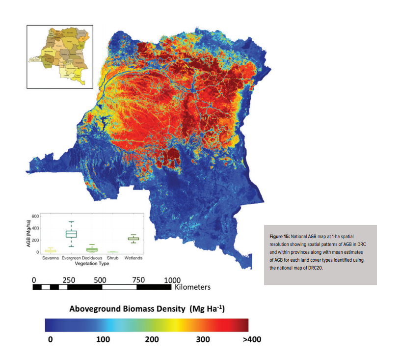
- Researchers were able to map the aboveground biomass in the DRC down to the one-hectare level using high-resolution airborne Light Detection and Ranging, or LiDAR, in combination with satellite imagery and machine learning geospatial algorithms.
Researchers have compiled the first-ever carbon map of rainforests in the Democratic Republic of the Congo (DRC).
The DRC is home to 60 percent of the Congo rainforest, the second-largest contiguous tract of tropical forests in the world. These forests not only store an immense amount of carbon but also harbor more than 15,000 plant and animal species, making the Congo rainforest one of the world’s most important biodiversity hotspots. But the DRC’s forests are facing significant threats from firewood collection, logging, mining, and slash and burn agriculture, as well as the impacts of poaching.
According to WWF, which partnered with the the Ministry of Environment of the DRC and researchers at the University of California, Los Angeles (UCLA) to map the aboveground biomass in the Central African country, “the success of the international initiative known as REDD+ (Reducing of Emissions from Deforestation and Degradation) is essential to supporting efforts to reduce global climate change” — and the new carbon map will prove invaluable to the implementation of REDD+ initiatives in the DRC.
The UN’s REDD+ program was included in the Paris Climate Agreement as a standalone article, signaling the importance of forest conservation and rehabilitation within broader efforts to rein in global carbon emissions and mitigate climate change. An estimated 10 percent of the world’s total greenhouse gas emissions are due to deforestation.
“This national map effectively estimates the carbon stock stored in every hectare of DRC’s forests, supporting national efforts to monitor forest cover and facilitate the assessment of carbon emissions from deforestation, in order to receive eventual payments from REDD+,” WWF said in a statement accompanying the release of the map and an associated report.
Researchers were able to map the aboveground biomass in the DRC down to the one-hectare level using high-resolution airborne Light Detection and Ranging, or LiDAR, in combination with satellite imagery and machine learning geospatial algorithms, a method developed by Dr. Sassan Saatchi, an expert on tropical forests and the global carbon cycle at UCLA’s Institute of the Environment and Sustainability and NASA’s Jet Propulsion Laboratory. Employing LiDAR data not only allowed for highly precise estimates of aboveground forest structure, the researchers note in the report on their findings, but also represents a cost-effective means of collecting the necessary data even in remote and inaccessible regions.
They concluded that, overall, there are roughly 22.9 gigatons of carbon stored in the humid tropical forests of the DRC. Armed with that information, the DRC government can better plan its future conservation efforts — and how they might be funded.
REDD+ works by placing a monetary value, on a per-hectare basis, on the carbon stored in forests that is prevented from being released into the atmosphere by conservation initiatives, Saatchi notes in a statement. Prices typically range from $20 to $50 per hectare.
“It becomes a huge asset for countries that have millions and millions of hectares of forest,” Saatchi said. “Each hectare has almost 100 to 200 tons of carbon. If you multiply the numbers, it becomes billions of dollars. It has developed a completely new economy in the world.”
Saatchi and team also looked at how carbon distribution correlates to rainfall patterns, soil types, and the topography of the DRC. “It gives us a picture of how the land looks, the structure of the landscape, vegetation types and how it all changes over time,” he said.
“We have detailed measurements that can tell us if a single tree falls or a little shack is built in the middle of the forest,” Saatchi added. “We captured that around the whole country.”
In order to present the clearest possible picture of the carbon conservation opportunities in the DRC, Saatchi and team looked at forest cover and carbon storage not only at the national level but also in all 26 of the DRC’s provinces, thus providing baseline estimates that forest management and protection initiatives in the country can use in designing their conservation targets. What’s more, these estimates can be updated in the future in order to track the impacts of deforestation and economic development projects going forward, as well as the success of reforestation efforts.
“Tropical forests provide valuable ecosystem services, notably by storing vast amounts of biomass, serving an important role for climate change mitigation,” the researchers write in the report. “In a national REDD+ policy framework, historical reference emission levels (potentially modified by one or several adjustment factors) will need to be set, and future emissions must be evaluated against the reference level as part of a monitoring (or measuring), reporting and verification (MRV) system to determine whether a country has or has not made significant emission reductions.”
The researchers found that four provinces — Ituri, Sankuru, Tshopo, and Tshuapa — have the highest levels of aboveground biomass, at more than 300 megagrams per hectare (Mg/ha). Ten other provinces were estimated to have around 200 Mg/ha. Combined, those 14 provinces account for as much as 75 percent of the total carbon stored in the DRC’s rainforests, suggesting where forest carbon conservation initiatives might best be targeted.
Bruno Perodeau, Conservation Director of WWF-DRC, expects the new biomass map to be a significant boon to forest conservation efforts in the DRC. “It will fill important knowledge gaps on the second largest tropical forest in the world, including its potential role in mitigating global climate change,” he said. “The results of this project will hopefully enable robust scientific monitoring, reporting and verification systems for performance payments for populations involved in REDD+.”
The map will not only be used to inform REDD+ projects, however — it can also be used to help guide land-use planning and development decisions so that the most important forests, from a carbon storage standpoint, can be kept relatively intact.
And the lessons learned through this research aren’t only applicable in the DRC. The researchers note in the report: “Our results indicate that the methodology can be applied to other tropical countries to provide cost-effective and efficient assessment of forest carbon storage and changes over large areas.”

Follow Mike Gaworecki on Twitter: @mikeg2001
FEEDBACK: Use this form to send a message to the author of this post. If you want to post a public comment, you can do that at the bottom of the page.