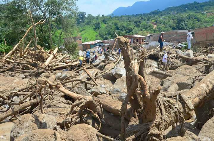
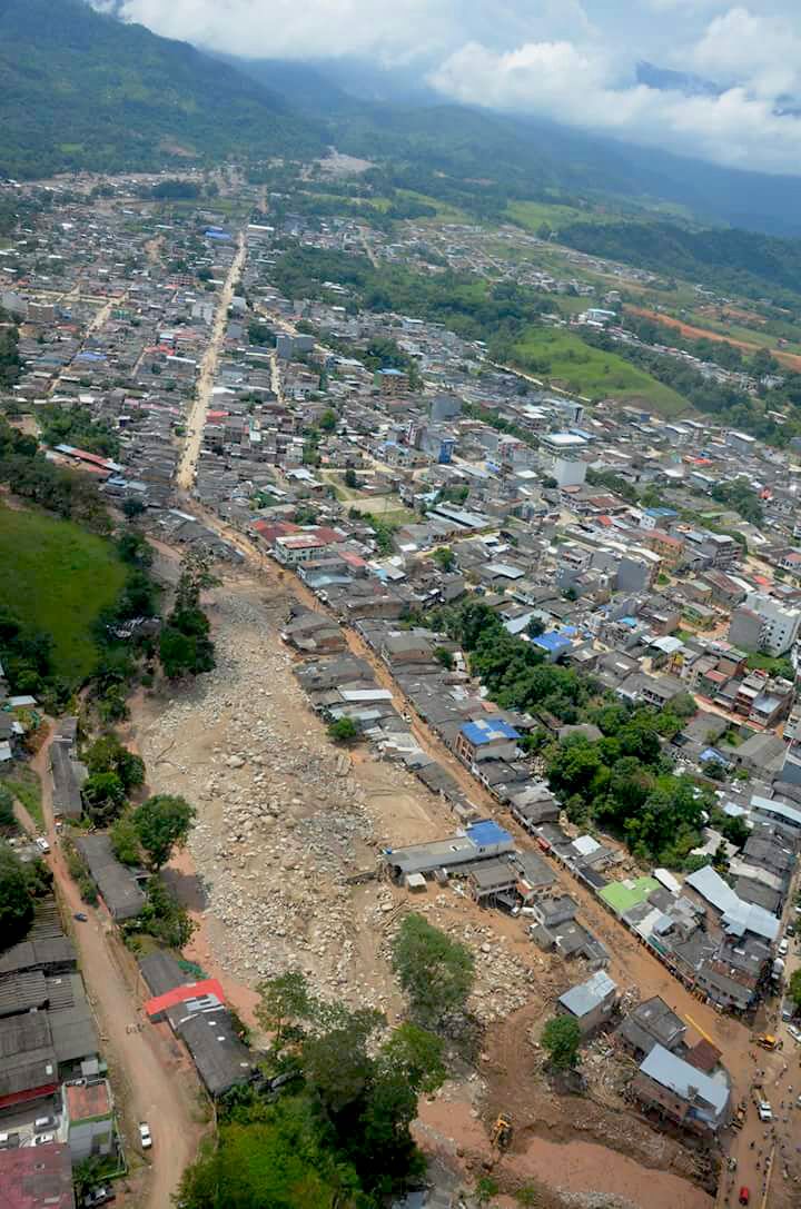
- On the morning of April 1, more than 60,000 people were hit by a massive landslide that dragged large amounts of water, dirt and mud downhill and buried 17 neighborhoods of Mocoa in the process.
- For risk management expert Gustavo Wilches-Chaux, the lack of land use planning is one of the factors that determined the impact of this natural disaster.
- Wilches-Chaux notes that some Colombian populations have settled along the tributaries of the main rivers of the country — areas highly vulnerable to floods, landslides and avalanches.
Mocoa, Colombia – The recent landslide disaster in Mocoa, the capital city of Colombia’s southwestern Putumayo region, left 254 people dead and 203 hospitalized, according to the latest report issued by the National System for Disaster Risk Management (SNGRD). The Corporation for the Sustainable Development of the Southern Amazon (Corpoamazonia) warned about such a possible disaster back in 2015.
On the morning of April 1, more than 60,000 people were caught by surprise when a landslide dragged massive amounts of water, dirt and mud downhill, and buried 17 neighborhoods of Mocoa. It also completely wiped out the neighborhood of San Miguel and devastated portions of the Laureles, San Fernando and Progreso neighborhoods, according to regional authorities. On Sunday, April 2 more than 1,300 SNGRD operatives, made up of personnel from the military, police, civil defense, fire department and the Red Cross were dispatched. The government sent 10 helicopters, six airplanes, seven boats and 63 other vehicles to support the specialized rescue personnel.

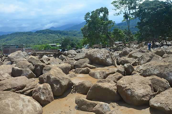
The landslide proved tragically what is already well-known: Putumayo and its capital city have a critical environmental situation. The geography, soil, steep slopes and nearby streams were all factors that contributed to the landslide. Located on the slope of a mountain, the city is at risk when the Mocoa, Sangoyaco and Mulato Rivers overflow.
Although the federal government has denied the possibility of another landslide in Mocoa in a press release issued by the SNGRD, Corpoamazonia disagrees. Corpoamazonia says that the difficulty of cleaning the riverbeds, due to big fallen rocks and trees, could generate new obstructions in the streams and rivers, and therefore cause more flooding. The organization’s experts believe that the alert for the Mulato and Sangoyaco rivers and the streams of Taruca, Conejo and Almorzadero —which were the ones responsible for the disaster in Mocoa— are still in force.
Corpoamazonia believes that an obstruction of the Mocoa River’s main channel generated the violent landslide, which wiped out hundreds of homes located north of the municipality of Mocoa.

For Luís Alexander Mejía Bustos, director of Corpoamazonia, there is still a red alert, as he stated in an interview granted to Semana Sostenible. According to the director, an overflight showed that the slopes of the streams are fractured, there is river erosion and a lot of debris on the riverbeds and banks.
“In fact, there is so much debris that if it rained again like it did on Saturday morning, a replica of the tragedy would happen again,” Mejía said. “The rivers still need to reach their base level and that will take a considerable time.”
Other experts agree that the situation is still dangerous. The early warnings issued in the Institute of Hydrology, Meteorology and Environmental Studies’ (IDEAM) daily bulletins remain on high or red alert because rainfall will continue, high volumes of precipitation will fall in the upper basins of the Putumayo rivers and in the Amazonian foothills. IDEAM has also issued an orange alert, which warns of potential landslides throughout the Amazon region.
Although deforestation is considered one of the main causes of the Mocoa disaster, IDEAM and Corpoamazonia experts agree that a number of factors, including rainfall volume and geological instability in the area, are also to blame.
Mocoa Mayor José Castro, told Mongabay what happened the night of the disaster. “We got out of the house when we heard a tremendous noise, the land roared, but we did not know what it was, and we watched the river take away what was in front of us, entire houses,” he said. “People were caught in the mudslides, but we were able to get out of there.”
A foreseen disaster
In 2015, Corpoamazonia and the government of Putumayo carried out modeling studies to accurately assess the area’s risk of flooding. The technical data obtained confirmed that natural phenomena of great proportions, such as the one that occurred in April, could happen, according to Luís Alexander Mejía Bustos, director of Corpoamazonia.
In an interview with Semana Sostenible, Mejía said that they warned authorities that disasters such as the recent one could happen due to the “inadequate use of the land” during a workshop with the Colombian Geological Service. They also noted that several Amazonian municipalities such as Mocoa “had not updated their Land Management Plan.”
In addition to the Corpoamazonia-Putumayo study, several reports by IDEAM issued the same day of the tragedy in statements sent to all the authorities of the country. Omar Franco, director general of IDEAM, told Mongabay that they also issued an alert for heavy rain and possible landslides in the Municipality of Putumayo in addition to statements given to the central government by Mocoa’s mayor.
An alert for heavy rains in the Putumayo region were sent the day before the landslide, warning that March 30 had been the second rainiest day of the month and heavy rains were predicted in the Amazonian foothills and the slopes of the Putumayo region. The night before the disaster, according to IDEAM, 129.3 millimeters (5 inches) of rain fell in the municipality of Mocoa, equivalent to the volume of water that would normally fall over ten days in this part of the Amazon foothills.
According to Franco, the concentration of rain was so intense during the night that it increased the magnitude of the disaster and made the tragedy worse. He also said that in the last 25 years, rainfall higher than that has been recorded, but the difference lies in the volume of rain. This time, it was distributed over 24 hours and in Mocoa specifically, and only within three hours.

According to IDEAM’s Franco, the phenomena caused by heavy rains is something that cannot be avoided. “The level of vulnerability of the population, the loss of vegetation cover and the lack of monitoring of those areas, is what makes these heavy rains have a greater impact,” he said. He added that to prevent recurring disasters, it is necessary to have better control of these variables and work on deeper concepts such as land use management.
Possible factors of the tragedy
On the day of the disaster, environmental authorities flew over the affected areas and saw proof of what scientific studies had already established.
Iván Darío Melo, deputy director of the environmental management sector of Corpoamazonia, said his organization found conditions of vulnerability in the affected area, how changes in land use and the occurrence of pastures have displaced the forest which previously helped in the regulation of water, and protection and containment of the rivers located in the upper basin.
With less forest area, the biological material of the soil is more susceptible to erosion, Melo explained, and if steep slopes are taken into account — with slopes between 50 and 100 degrees — the scenario for the natural disaster was evident. Melo said heavy rain that began around 10 p.m. the night before was the final ingredient for a landslide. “Hours later I was talking with a friend through social media and the last thing she said to me was: ‘the stream is roaring,’” Melo said. Her name now appears on the list of missing people, next to dozens who are missing.
IDEAM alerts had also reported deforestation and land use change in the municipality.
Human presence in river basins is another factor that Melo says should not be overlooked. According to him, “Many settlements exist on river banks and only when these things happen do we understand that rivers are dynamic and they need space to move.”
Is deforestation the cause of the tragedy?
In the last 25 years, the region of Putumayo has been leading the deforestation figures in Colombia, with the loss of 380,000 hectares (939,000 acres), according to IDEAM. Putumayo has the fifth-highest regional deforestation of Colombia.
Edersón Cabrera, coordinator of IDEAM’s forest monitoring system, said that while the Mocoa situation is not the most worrying in the region, deforestation in the 1990s and 2000s — especially in the upper parts of the Mocoa River basin — did cause landslides.
“More than 10,000 hectares have been deforested over the last 25 years in the Mocoa River basin, with the highest peaks occurring from 2000 to 2005 and 2005 to 2010, averaging 700 hectares deforested annually in that part of the municipality,” Cabrera explained.

When high-intensity precipitation occurs over short periods, soil becomes saturated and then tends to slide. In this scenario, trees and vegetation typically help to counteract the problem, a role that pastures and crops can not fulfill because they don’t have the type of roots that can contain or mitigate landslides.
According to Cabrera, IDEAM analysis has found that deforestation over time has made certain areas more susceptible to landslides. “In the case of the Mocoa River basin, because river banks are so steep, the sediments that go to the riverbeds cause blockages (obstructions) resulting in these phenomena,” Cabrera said.
Land use management: a fundamental problem
According to the IDEAM director Franco, there are more than 500 municipalities in Colombia that are at differing risk levels, 185 of them are on orange or red alerts, warning that they could be affected by landslides.
For risk management expert Gustavo Wilches-Chaux, the lack of land use planning is one of the factors that determined the huge impact of the Mocoa landslide.
Wilches-Chaux said some Colombian populations have settled in the tributaries of the main rivers of the country, putting their lives at risk. The areas are highly vulnerable to floods, landslides and avalanches. He said it is not a question of imposing human priorities on the dynamics of nature, but of ordering social needs in such a way that they don’t clash with the dynamics of ecosystems. He said that in order to avoid future disasters, early warnings should be heeded and there should be greater collaboration with communities on land use planning.
“Climate change and extreme climate variability are forcing us to address the management of territories from a non-anthropocentric ethic, instead based on the recognition of the rights of nature and respect for all human beings and non-humans who share the earth,” Wilches-Chaux said.
Cover photo courtesy of Corpoamazonia
This story was reported by Mongabay’s Latin America (Latam) team and was first published in Spanish on our Latam site on April 3, 2017.