- Indonesia’s environment ministry responds to Greenpeace’s critique of its official declaration of baseline emissions in Paris.
- The ministry defends its emissions reporting, saying Greenpeace’s analysis is off the mark.
- The back-and-forth between the government and the NGO shed light on issues with Indonesia’s peat mapping, data transparency and more.
Several weeks ago during the UN climate talks in Paris, Greenpeace published an analysis of Indonesia’s baseline emissions reporting to the summit, finding “serious issues, omissions and errors” with the Southeast Asian country’s official documentation.
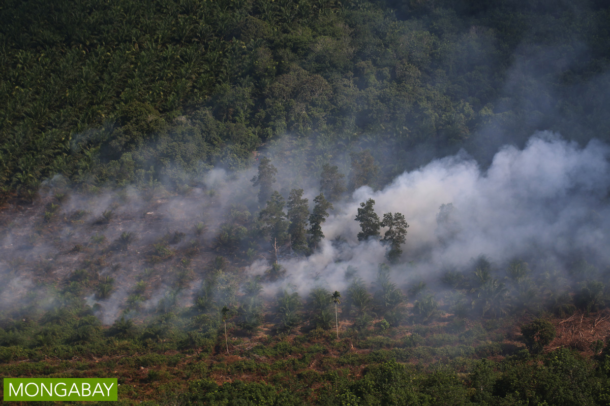
The NGO said the Indonesian government had dramatically underestimated deforestation and peatland degradation in the archipelago. It also took issue with the exclusion of emissions from Indonesia’s annual wildfires, which this year were particularly devastating because of an extended dry season brought on by El Nino. Greenpeace ultimately argued that Indonesia’s too-low emissions figures undermined its prospects for receiving international assistance for peatland protection and REDD+ schemes and needed to be revised.
A Mongabay query about the Greenpeace analysis initially went unanswered by Indonesia’s environment ministry. Last week, however, a ministry representative responded to a request for comment and ultimately provided a defense of the documentation, known as the Forest Reference Emissions Levels (FREL), a key component of Indonesia’s Intended Nationally Determined Contribution (INDC) to reduce emissions.

Peat coverage
The FREL used maps that showed 15 million hectares of peat, but Greenpeace argued the most reliable figure was 22 million hectares, the result of a joint study by Wetlands International and the government in the early 2000s. Indonesia’s agriculture ministry later produced the former figure, which Greenpeace said was suspect.
The environment ministry defends the revision. “In the year 2011, after doing more comprehensive field measurements aimed at improving the quality of the existing peat map, the Ministry of Agriculture published the updated peat map with area of 14.9 million hectares,” an environment ministry official told Mongabay.
Greenpeace isn’t swayed. It points out that the methodology behind the 2011 figure has been questioned by specialists working with Indonesia’s development ministry, which in 2013 described the smaller figure as less accurate than the larger one.
Nevertheless, the environment ministry maintains that the agriculture ministry is the official custodian for peat data, which is why its figure was used in the FREL.
The development ministry’s 2013 study actually concluded that both figures were probably underestimates.
“Greenpeace urges the government to commission full scale LiDAR-based mapping of all potential peatlands in Indonesia, to increase the reliability of available peat maps,” the NGO told Mongabay, referring to a technology now being used by the private sector to map peatlands in Sumatra. “This is essential for all future planning.”

Fire emissions
The emissions from annual wildfires over the 1990-2012 baseline period were left off the accounts because of the “complicated and highly uncertain nature” of calculating them, according to the FREL. Greenpeace disputed that logic, saying Indonesia could have used an estimate of the figure and that it was “nonsensical” to omit it entirely.
The environment ministry holds to its original reasoning, saying the actual fire emissions figure is too uncertain to include. “Please note, if the FREL calculation truly has weaknesses or is hiding something, it would be questioned and tested by the reviewers from UNFCCC,” the ministry told Mongabay, referring to the United Nations Framework Convention on Climate Change. “Greenpeace should know about this.”
The ministry further cites the explanation in the FREL itself, which justified the omission because the fire emissions would be factored into peat degradation figures over the long term.
Michael Wolosin of Climate Advisors has defended the ministry’s approach, saying that Greenpeace “seems to suggest that the Indonesian government is lying about or trying to hide the biggest source of emissions from its own people and the UNFCCC – emissions from peat fires and draining. This simply is not true.
“Indonesia included these emissions in their GHG reporting to the UNFCCC, and promised to update the estimates in its next GHG report to the UNFCCC. The purpose of a Forest Reference Emission Level (FREL) is to establish a baseline for REDD+ funding – and the Indonesian government should be applauded, not berated, for leaving out peat emissions until they are confident in the estimates. By doing so, it is true that they may reduce international finance flows to Indonesia for REDD+ in the near term – but they also build trust in the global REDD+ system by avoiding any potential ‘hot air’. This is the kind of careful conservatism that Greenpeace should appreciate.”
Greenpeace continues to argue against that approach. “There is no excuse for excluding peat fire emissions from calculations, despite uncertainties. The uncertainties are not unique to peat, but many emissions sources. This is like trying to prevent public linking of smoking or asbestos to health.
“The exclusion of these peat emissions from the FREL minimizes Indonesia’s land-based emissions baseline. As a result, Indonesia risks missing important opportunities to reduce emissions and prevent fires through forest and peatland protection, including REDD+ initiatives and private sector contributions.”
Transparency
Greenpeace also raised the question of transparency, saying the government had not made the underlying maps and justifications for changes in data available for public scrutiny.
The environment ministry says Greenpeace and other NGOs were invited to and attended the soft launch of the FREL in September. “All doubts and questions that Greenpeace released in the letter to the President actually can be delivered during the process of FREL developments and/or articulated during the soft launch. Yet, Greenpeace never raise any questions nor sending any email to the team in regards to the questions they finally delivered to the President.”
Greenpeace takes issue with that characterization, saying the September event took the form of a one-sided presentation rather than a workshop in which the public could give meaningful input into the FREL. The NGO added that the FREL draft was not distributed at the event.
The ministry also faults Greenpeace for basing its critique on a draft version of the FREL, since the final version could only be published online after its submission to the UNFCCC during the climate summit, according to UNFCCC rules. The final version was subject to “internal improvements and finalization” that Greenpeace didn’t consider.
Greenpeace says it had to use a draft, which it obtained through unofficial means, because nothing else was available.
In response to Greenpeace’s claim that the underlying data and maps have not been made available to the public, the ministry says Greenpeace has received spatial data for things like land cover and forestland use. “The data is actually available as a map service on the Ministry website. Greenpeace has also experienced training that was facilitated by the World Resources Institute and the Ministry in how to use the map service.”
Greenpeace disputes that, saying the only data the ministry has shared with it officially “in GIS format (shape file) are the landcover data for the years 2009 and 2011. Greenpeace recently handed in a Freedom of Information request to get landcover data also for the remaining years (amongst others) and was turned down by the Ministry. The case is now with the [Public Information Commission].”
Greenpeace is one of several NGOs to file a freedom of information request with the ministry over the release of shape files, which are needed to perform more advanced analysis. The ministry has said it is unsure of the legality of making the shape files publicly available.


