
- An oil palm company’s concession in Central Kalimantan is said to lie on a stretch of deep peat that was removed from Indonesia’s forestry moratorium based on an erroneous government survey.
- The concession is now full of fires, fueling the haze crisis that is contaminating the air in Indonesia, Malaysia and Singapore.
- A presidential unit on development oversight was investigating the concession last year until it was disbanded by the new president in December.
A massive peat dome on Borneo’s southern coast is under threat from an oil palm firm whose area of operation should never have been removed from Indonesia’s moratorium on new licenses to clear primary forests and peatlands, according to individuals from the private, public and nonprofit sectors who have investigated the company’s concession.
Land clearing has begun, threatening local orangutan populations and jeopardizing a nearby conservation project, sources say. Work on drainage canals started six months ago. The company, PT Persada Era Agro Kencana (PEAK), has planted its first oil palm seedlings.
The concession is also full of fires, fueling a severe outbreak of smoky haze across the region which counts this province of Central Kalimantan as a critical epicenter.
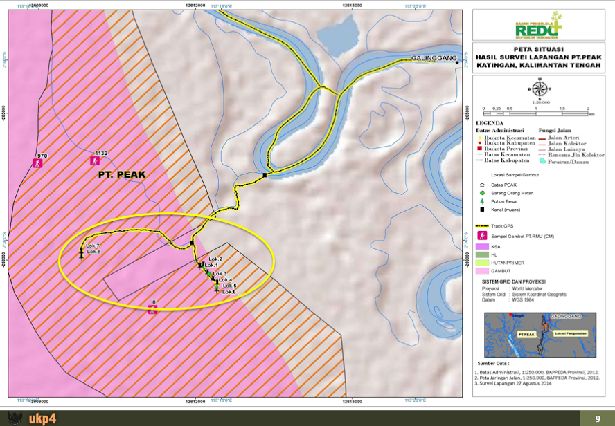
The concession was brought to Mongabay’s attention by Dharsono Hartono, CEO of PT Rimba Makmur Utama (RMU), which holds an ecosystem restoration license to manage around half of the peat dome, located between the Mentaya River to the west and the Katingan River to the east near the Java Sea.
Dharsono said PEAK’s activities threaten the viability of RMU’s project, set up for the purpose of selling carbon credits for profit and tackling climate change in line with Indonesia’s REDD+ initiative.
He explained that the draining of PEAK’s concession – peat is a carbon-rich, marshy material that must be drained before it can be planted with oil palm – will lower the water table in RMU’s zone and jeopardize the green investment project, which covers 108,255 hectares.
“The impact of their land clearing will be very detrimental to us, because it’s one ecosystem,” Dharsono said. “If they open land in a massive way, it will interfere with what we’re doing.
“In the short term, the impact will not be severe. But in the long term, the peat dome in the region will be affected, and there is potential for wildfire.”

That potential has already become a reality, whether as a result of PEAK’s activities or not.
Forty-nine hotspots are burning near the Katingan River where PEAK’s concession lies, according to Global Forest Watch Fires.
Reza Lubis, an ecologist with Wetlands International who visited the area in early September, confirmed the presence of fires in the concession – and said PEAK was doing little to fight them.
“The area is huge, maybe 50 hectares, and [PEAK] just put 10 people with one small pump,” said Reza. “So maybe [the deployment] is just a formality.”
“I don’t have any proof that they started the fires,” he added. “They blame of course the community in the area, and the community is angry about that. They demand the company to apologize.”
Fire is often used illegally as a tool to clear land cheaply for agriculture.
The flames, Reza added, are spreading to forested areas and also toward the border with RMU.

Reza and Dharsono both say PEAK’s area consists of peat, meaning it never should have been removed from the moratorium, established under an agreement with Norway in 2011.
The company’s digging of drainage canals, Reza said, is a “clear indication that they are aware it is indeed peat. Otherwise they would just build roads instead.”
Dharsono concurred: “I can assure you that based on our experience in the field, the majority of the area is peat.”
The moratorium map, revised every six months, was redrawn by the Forestry Ministry (since merged with the Environment Ministry) in 2013 to exclude the area covered by PEAK’s concession after the company applied for its removal on the grounds that it is not actually peat.
In June last year, after Yayasan Puter Indonesia (YPI), an NGO focused on rural Kalimantan, reported it really does consist of peat, a now-defunct presidential unit on development oversight, known as the UKP4, wrote to the Forestry Ministry requesting an explanation for the decision, correspondences show.
In July, the ministry wrote back, saying the decision was based on a survey by an Agriculture Ministry bureau – the Research and Development Center for Land Resources (BB SDLP) – which had concluded that of the 18,222 hectares PEAK wanted removed from the moratorium, 11,307 hectares were not peat and could thus be taken out. (PEAK was ultimately allocated 12,906 hectares.)


In August, the UKP4 conducted its own investigation, entering the field without the company’s knowledge to check the soil composition.
The ground check revealed deep peat at several points. There were also orangutan nests, as well as large birds of prey, indicating a stable food web and healthy ecosystem.
The UKP4 alerted the Forestry Ministry to its findings. But in December, the unit was disbanded by new President Joko “Jokowi” Widodo, who had taken office in October.
The onus of the investigation passed to the National REDD+ Agency (BP REDD), but in February it too was disbanded, folded into the newly merged Environment and Forestry Ministry as Jokowi motioned to streamline government and reduce overlap.

Dharsono said that while he doesn’t want to blame anybody, “the fact is that the [BB SDLP] report is not portraying what’s on the ground.”
BB SDLP chief Dedi Nursyamsi did not respond to a request for comment.
Neither did Andre, the man said to own PEAK. His phone was turned off when Mongabay called, and he did not reply to a text message.
San Afri Awang, the Environment and Forestry Ministry’s new director-general of spatial planning, said he would follow up on the matter.
“This should be checked immediately,” he told Mongabay.
Karya Darma, an official from the Katingan district government, said that as far as he knows everything with PEAK’s concession is in order.
“To my knowledge, [the concession] is not on land covered by the moratorium,” he said.
“We wouldn’t dare issue a license on peat,” he added. In Indonesia, district governments control key oil palm permits.

If the area on which PEAK is operating truly does consist of peat, its removal would not be the first irregularity associated with Indonesia’s moratorium. According to NGOs, clearing in breach of it, mainly due to its lack of teeth, is widespread.
YPI, the Kalimantan-focused NGO, originally flagged 12 peatlands as having been removed from the moratorium, not just the one. The sites are dispersed across Katingan, Kapuas, Pontianak and Ketapang districts in West and Central Kalimantan provinces.
Nirarta Samadhi, former deputy head of the UKP4, said that when a company applies for an area to be removed from the moratorium because it is not peat or primary forest, it is up to the government to analyze the claim.
“That is by the book,” he said. “In practice, more often than not, it is the company itself that provides the analysis. What the government then does is verify that.”
The government is generally underresourced, and companies in this situation can work faster, he added.
“But then again if the company does it, probably a lot of mishaps happen, because then the government officer who verifies it doesn’t necessarily do a complete job – they still lack the manpower and capacity.”
While cases like PEAK’s are “quite common,” Nirarta believes, the YPI report about it was one of only a few such complaints the UKP4 dealt with during his tenure. He attributed this to complaints not always going up to his unit but probably more often being handled by the Forestry Ministry or the Geospatial Information Agency (BIG).
Iriana Jayasantika, a YPI staffer, said that after the NGO flagged the 12 sites, the Forestry Ministry asnwered that in most of them, concessions had been issued before the moratorium took effect in 2011.
“We couldn’t probe any deeper than that,” Iriana told Mongabay. “The ministry wasn’t open.”
Backdating of permits issued after the moratorium’s start date is not uncommon, said Yuyun Indradi, forest campaigner at Greenpeace Indonesia.
The current problem, Yuyun added, is that the Environment and Forestry Ministry is less transparent with moratorium data than were the UKP4 and BP REDD, which would post the maps online so NGOs could download them.
“It used to be open to the public,” he said. “Now it’s all closed. We tried to submit a letter of request for the digital version of the latest map, but the ministry refused. So we’re having difficulties analyzing what’s happening with the new map.”
Iriana doesn’t think PEAK’s area is the only peatland to be illegitimately removed from the moratorium.
“The problem is systemic,” he said. “They revise the moratorium map every six months, but it never really grows – it just keeps shrinking.
“Maybe that’s why there’s so many fires,” he added with a chuckle.
