
Carnegie Airborne Observatory map showing carbon in along the main stem of the Amazon in Peru. All images courtesy of the Carnegie Airborne Observatory/Greg Asner
Nearly a billion tons of carbon in Peru’s rainforests is at risk from logging, infrastructure projects, and oil and gas extraction, yet opportunities remain to conserve massive amounts of forest in indigenous territories, parks, and unprotected areas, finds a study published this week in Proceedings of the National Academy of Sciences (PNAS).
The research is based on a comprehensive assessment of Peru’s carbon stocks using an advanced laser-based mapping system. The system, developed by a team led by Greg Asner of the Carnegie Institution for Science, enables scientists to map three dimensional vegetation structure at extremely high resolution, well beyond the capabilities of conventional satellite-based systems.
The mapping work revealed the extent of above-ground carbon storage across landscapes and ecosystems — ranging from farmland to Andean cloud forests to dense rainforests — in Peru. Asner and colleagues then overlaid the carbon map with land use data, including various concessions, indigenous reserves, illegal mining areas, and protected and unprotected areas, revealing potential greenhouse gas emissions and opportunities for carbon conservation.
 Carnegie Airborne Observatory map showing carbon in Iquitos and the surrounding area. Click image to enlarge Carnegie Airborne Observatory map showing carbon in Iquitos and the surrounding area. Click image to enlarge
|
 Carbon map showing forests and illegal gold mining. All images courtesy of the Carnegie Airborne Observatory/Greg Asner Carbon map showing forests and illegal gold mining. All images courtesy of the Carnegie Airborne Observatory/Greg Asner
|
|
“We found that nearly a billion metric tons of above-ground carbon stocks in Peru are at imminent risk for emission into the atmosphere due to land uses such as fossil fuel oil exploration, cattle ranching, oil palm plantations and gold mining,” Asner said in a statement.
The largest emissions are expected to result from selective logging operations and oil and gas development (660 million tons). Secondary drivers of emissions including agricultural conversion, expanding palm oil production, and gold mining, which the authors caution could ultimately result in forest loss that outpaces their emissions projection of 140 million tons. The authors add that those latter three activities result in much higher emissions than logging and energy development since they involve large-scale clearance of forests and are concentrated in lowland areas which store higher amounts of carbon.

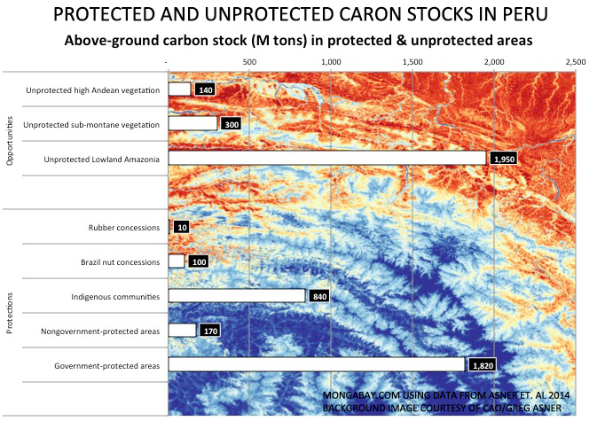 At risk carbon stocks and carbon stock opportunities in Peru. Click images to enlarge.
But the study also highlighted potential opportunities to avoid potential emissions.
“The good news is that our high-resolution mapping was able to identify three strategies for offsetting these upcoming emissions,” said Asner. “Transitioning partially protected preserves to fully protected ones would help to counterbalance a great deal of the carbon that is expected to be lost due to land use in the near future.”
Protecting 22.6 million hectares of unprotected lowland Amazon forest is a particularly ripe opportunity, amounting to nearly 2 million tons of carbon. Adding in sub-montane forests would boost the area to 30 million hectares and total above-ground carbon stocks to 2.3 billion tons.
The authors also urge better protection of existing protected areas as well as support for indigenous territories, which house 840 million tons of carbon. They add that using reduced-impact logging, restricting access to roads, and using roadless approaches to oil and gas extraction could help curb future emissions from already-planned activities.

High resolution image showing carbon stocks along the Trans-Oceanic Highway in Peru. Courtesy of the Carnegie Airborne Observatory/Greg Asner
The Peruvian government added that the maps will help with efforts to receive international payments for forest conservation.
“Research is necessary to determine the exact state of our forests,” stated Manuel Pulgar-Vidal, Peru’s Minister of Environment, “This new map provides the evidence needed to start negotiating in the carbon market at a bigger scale. Our government is also studying carbon stocks in the soil, and is doing a forest inventory, and we have a forest investment program. These initiatives will better prepare us to face changes in land use.”
The researchers closed by noting the methodology could be used beyond Peru.
“The approach that we have developed and implemented can be rapidly updated at low cost, significantly reducing the lag times of years to decades incurred when using field plot inventory approaches alone. Our project cost was approximately 1 US cent ($0.01) per hectare when applied over the entire country of Perú,” they write. “This high-resolution, rapid assessment methodology can be replicated and applied anywhere in the world.”

Annual forest loss in Peru, 2001-2012, according to research led by Matthew Hansen of the University of Maryland.
CITATION: Gregory P. Asner et al. Targeted Carbon Conservation at National Scales with High-Resolution Monitoring. PNAS Online Early Edition for the week of Nov 10-Nov 14, 2014.