A satellite image released by NASA last week shows a key channel that forms part of the Northwest Passage is partially free of ice.
The image, acquired by the Moderate Resolution Imaging Spectroradiometer (MODIS) on NASA’s Terra satellite, shows that more than two-thirds of the Parry Channel was ice-free on July 30. The median coverage for that date was 79 percent from 1980-2010. The Parry Channel separates Victoria Island from Melville Island in Canada’s far north.
Parry Channel is part of the northern route through the Northwest Passage. When navigable, the Northwest Passage offers a shortcut between the Atlantic and Pacific Oceans.
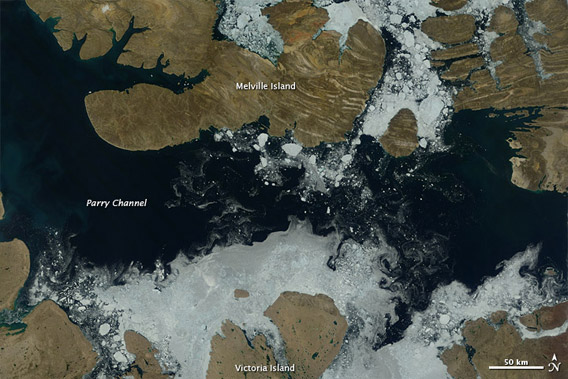 Image acquired August 3, 2012 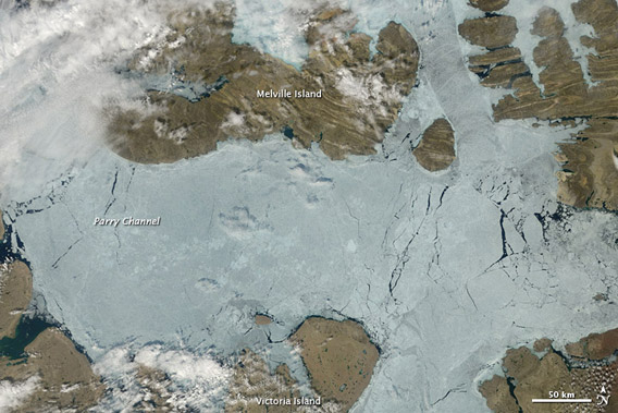 Image acquired July 17, 2012.  The top image shows Parry Channel on August 3, when some ice was still clinging to the shores of Victoria and Melville Islands but open water otherwise dominated the region. The second image shows Parry Channel on July 17, 2012, when ice filled the channel. NASA Earth Observatory images by Jesse Allen, using data from the Land Atmosphere Near real-time Capability for EOS (LANCE)  Courtesy of Google Maps |
In recent years sea ice cover in the Arctic has declined substantially due to warming temperatures. Sea ice typically reaches its minimum extent in mid-September.
Predictions range widely, but many experts expect the Arctic to be free of summer sea ice entirely within a few decades. By almost all standards, sea ice is disappearing faster than expected, partly a consequence of a positive feedback loop triggered by retreating ice. Sea ice typically helps cool the Arctic by reflecting sunlight back into space. But when sea ice melts, the dark areas of open water absorb the sun’s radiation, warming the region and worsening melting.
Related articles