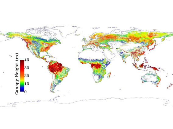
NASA map of global forest height, the redder the taller, the bluer the shorter. Image courtesy of NASA.
The height of a forest is important in a number of different ways. First the taller a forest, the more likely there are important niche habitats in the canopy providing homes to unique species. In addition, a forests’ height says something about its ability to sequester carbon: the taller a forest the more carbon it can hold. Now a team of researchers, led by NASA, has created the world’s first global map showing the height of the world’s forests (click here for interactive map), publishing their findings in the Journal of Geophysical Research.
“Our map can be used to improve global efforts to monitor carbon. In addition, forest height is an integral characteristic of Earth’s habitats, yet is poorly measured globally, so our results will also benefit studies of the varieties of life that are found in particular parts of the forest or habitats,” explains Marc Simard with NASA’s Jet Propulsion Laboratory in a press release.
The maps were created by employing lasers on NASA’s Ice, Cloud and land Elevation Satellite (ICESat). Laser pulses by the Light Detection and Ranging technology (LIDAR) produced a map whose resolution is 0.6 miles (1 kilometer).
“Our map contains one of the best descriptions of the height of Earth’s forests currently available at regional and global scales,” Simard adds. “This study demonstrates the tremendous potential that spaceborne lidar holds for revealing new information about Earth’s forests. However, to monitor the long-term health of Earth’s forests and other ecosystems, new Earth observing satellites will be needed.”
Not surprisingly the study showed that the world’s tallest forests are at low latitudes, while the shortest are at higher altitudes. Bucking this trend are the eucalyptus forests of Australia and New Zealand.
Related articles
Scientists create high resolution, 3D maps of forests in Madagascar
(02/15/2012) A team of scientists has created the first high resolution maps of remote forests in Madagascar. The effort, which is written up in the journal Carbon Balance and Management, will help more accurately register the amount of carbon stored in Madagascar’s forests, potentially giving the impoverished country access to carbon-based finance under the proposed REDD (Reducing Emissions from Deforestation and forest Degradation) program.
More big companies disclosing impacts on forests

(02/07/2012) More companies are reporting on the impact of their operations on global forests, finds a new report. Eighty-seven global corporations disclosed their “forest footprint” in 2011, according to the third Forest Footprint Disclosure (FFD), which asks companies to report on their impact on forests based on their use of five commodities: soy, palm oil, timber and pulp, cattle, and biofuels. This is a 11 percent rise from the companies that reported in 2010, including the first reports by companies such as the Walt Disney Company, Tesco UK, and Johnson & Johnson. However a number of so-called “green” companies continue to refuse to disclose, including Patagonia, Stonyfield Farms, and Whole Foods Markets Inc.
Rainforests store 229 billion tons of carbon globally finds new ‘wall-to-wall’ carbon map
(01/30/2012) Tropical rainforests store some 229 billion tons of carbon in their vegetation — about 20 percent more than previously estimated — finds a new satellite-based assessment published in the journal Nature Climate Change. The findings could help improve the accuracy of reporting CO2 emissions reductions under the proposed REDD program, which aims to compensate tropical countries for cutting deforestation, forest degradation, and peatlands destruction.