105,000 square miles of rainforest destroyed between 2000 and 2005
105,000 square miles of rainforest destroyed between 2000 and 2005
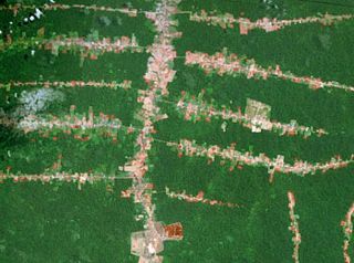
Rainforest destruction becomes industry-driven, concentrated geographically
Rhett A. Butler, mongabay.com
June 30, 2008
25 acres (10 hectares) of rainforest destroyed per minute between 2000 and 2005
|
|
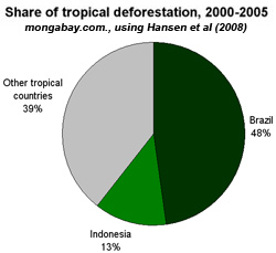
New analysis of global deforestation reveals that the bulk of tropical forest loss is occurring in a small number of countries. The research — published in the journal Proceedings of the National Academy of Sciences (PNAS) — shows that Brazil accounts for nearly half of global deforestation, nearly four times that of the next highest country, Indonesia, which makes up about an eighth of worldwide forest clearing.
The study comes in response to criticism of the main source of global deforestation data — the U.N. Food and Agriculture Organization (FAO) — at a time when accurate measurements of such data are critically important to emerging markets for ecosystem services, including carbon sequestration by forests. The results may help scientists better monitor deforestation, while facilitating more effective land-use policy responses from lawmakers and better targeted campaigns by environmental groups.
Remote sensing versus self-reporting
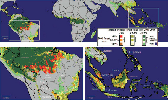 Total forest clearing over the study period is estimated to be 27.2 million hectares (s.e. 2.28 million hectares). Regional variation in clearing intensity is shown; Region 1 covers 6% of the biome and contains 55% of clearing; Region 2 covers 44% of the biome and contains 40% of forest clearing; Region 3 covers 50% of the biome and contains 5% of forest clearing. Data from this figure are available at globalmonitoring.sdstate.edu/projects/gfm. Courtesy of National Academy of Sciences, PNAS (2008). Click image to enlarge. |
Unlike FAO data, which are based largely on reporting from forestry departments of individual countries, the new estimates have been produced by analysis of a combination of satellite imagery from NASA’s Moderate Resolution Imaging Spectroradiometer (MODIS) and Landsat programs. The researchers say the integrated methodology offers a more accurate way to track change in forest cover.
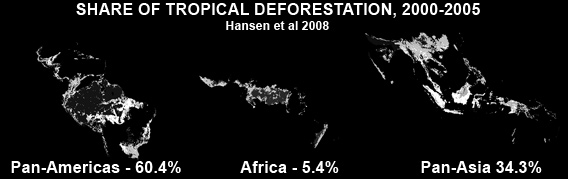
The researchers interpreted forest cover and forest clearing for 183 18.5-km by 18.5-km sample blocks taken across the tropics, using high-resolution Landsat imagery. They estimate that 27.2 million hectares (105,000 square miles) of tropical rainforest were cleared from 2000 to 2005, an area representing 2.36 percent of global tropical forest cover. Importantly, the analysis revealed significant differences in regional forest clearing, with over three-fifths of deforestation occurring in Latin America, one-third in Asia, and only 5.4 percent in Africa. Brazil, which is home to 60 percent of the Amazon rainforest, accounted for 47.8 percent of global forest loss. Indonesia and Malaysia — where oil palm plantations are rapidly expanding — ranked a distant second and third, respectively. The data show that 55 percent of total tropical humid forest clearing occurs within only 6 percent of the biome area, indicating the existence of deforestation “hotspots,” especially for Brazil and Indonesia where rates of forest loss — 3.6 percent and 3.4 percent, respectively — far exceed regional deforestation rates (1.2 percent for the rest of Latin America, 2.7 percent for the rest of Asia).
|
“The pattern of deforestation in the humid tropics for the current decade indicates concentrated areas with high rates of deforestation in Latin America and southeast Asia,” study co-author Ruth DeFries, a professor at the University of Maryland’s Department of Geography and Earth System Science Interdisciplinary Center, told mongabay.com. “With skyrocketing demand for biofuels and agricultural commodities, we can expect that deforestation in the future will be increasingly driven by large-scale industrial agriculture rather than small-scale landholders.”
Beyond Brazil’s 3.6 percent loss in its Year 2000 forest cover — concentrated in the so-called arc of deforestation in the states of Pará and Mato Grosso in the southern Amazon — the study uncovers several other deforestation hotspots.
“Latin American hotspots include northern Guatemala, eastern Bolivia, and eastern Paraguay. As a percentage of year-2000 forest cover, Paraguay features the highest areal proportion of change hotspots, indicating an advanced, nearly complete forest clearing dynamic,” the authors write.
“Indonesian island groups of Sumatra, Kalimantan, Sulawesi, and Papua feature varying degrees of forest removal, with Sumatra the site of the most intense recent large-scale clearing and Papua a measurable but low level of forest clearing. Riau province in Sumatra has the highest indicated change within Indonesia. Hot spots of clearing are present in every state of Malaysia, and clearing in Cambodia along its border with Thailand is among the highest of indicated change hot spots,” they continue.
|
“Africa, although a center of widespread, low-intensity selective logging, contributes only 5.4 percent to the estimated loss of humid tropical forest cover. This result reflects the absence of current agro-industrial scale clearing in humid tropical Africa.”
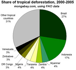
The new estimates differ significantly from those released in the FAO’s 2005 Forest Resource Assessment (FRA) report, which suggested a broader distribution of deforestation, including substantially higher forest loss in tropical Africa and Indonesia.
“The FRA 2005 report highlights Africa and South America as having the highest rates of forest area loss, both in excess of 4 million hectares per year,” the authors write. “For those African countries predominantly within the humid tropics, our humid-tropics-only estimate is less than one-third of the FRA estimate. For both this study and the FRA, Brazil and Indonesia are the countries featuring the highest forest clearing rates. However, our results differ as to the relative magnitude of change. For Brazil and Indonesia, the FRA reports annual change in forest area from 2000 to 2005 equal to 2.68 and 1.87 million ha/yr, respectively. Our estimates of forest clearing for Brazil and Indonesia are 2.60 and 0.70 million ha/yr, respectively.”
Fewer fronts for conservation efforts
Still, the finding that deforestation is increasingly concentrated geographically and driven by industry may hold significance for conservation efforts.
“I don’t think anyone interested in tropical deforestation would be shocked to hear the FAO data have problems, though they might not have realized just how serious the problems are,” said William Laurance, a tropical forest researcher at the Smithsonian Tropical Research Institute, who was not involved in the study. “These new data highlight just how alarming deforestation in Brazilian Amazonia has become in global terms — virtually half of the global total in recent years.”
“But the geographic concentration of deforestation, coupled with the shift from subsistence-driven to enterprise-deforestation forest clearing, may hold unexpected benefits for conservation: it may be easier for environmental groups to target their campaigns on major forest-destroying corporations and industries.”
Expanding the monitoring effort
The researchers hope to expand their study to more finely measure change in forest cover over time, a capacity that could prove useful to efforts to value forests for the carbon they contain. One proposed mechanism — known as Reducing Emissions from Deforestation and Degradation (REDD) — would aim to slow greenhouse gas emissions by compensating tropical countries for reducing deforestation rates from a historical baseline. Satellite imagery would play a key part in establishing this baseline and monitoring deforestation, though the authors say the effort will also require improving technical competence on the ground.
 Deforestation in the Brazilian Amazon. Courtesy of Google Earth. |
“Monitoring changes in forest cover across large areas is becoming increasingly feasible with satellite data for relatively low cost. The current policy emphasis on reducing deforestation as one approach to lower greenhouse gas emissions heightens the need for tropical forest countries to be able to monitor forests within their borders. This is a realistic goal, but attention needs to be placed on developing the technical skills and institutional capacity within the countries,” study co-author Ruth DeFries said.
Matthew Hansen, lead author of the paper and co-director of the Geographic Information Science Center at South Dakota State University, adds that finer resolutions and more consistent monitoring could help researchers better understand the regional drivers of land change in the tropics.
“We need operational systems that efficiently and accurately allow us to monitor forests,” he told mongabay.com. “Consistency is paramount. Currently, we have to compare various estimates from results reflecting different periods, different study areas, different definitions and different methods. Our approach is meant to be repeatable and to cover the whole biome, which we think is an advance. Our method to could be implemented retrospectively and prospectively in monitoring change over time.”
“This is the first quantitative map of pan-humid tropics forest loss that allows, at a glance, the comparison of regional variation in this dynamic. We like that aspect a lot and are pursuing such methods at finer spatial resolutions,” he told mongabay.com. “The idea is that with more effort, we could certainly have more detailed numbers.”
Matthew C. Hansen at al. (2008). Humid tropical forest clearing from 2000 to 2005 quantified by using multitemporal and multiresolution remotely sensed data. PNAS July 8, 2008 vol. 105 no. 27 9439-9444.
Related
Fire monitoring by satellite becomes key conservation tool March 27, 2008
Remote sensing is increasingly used as a tool for conservation management. Beyond traditional satellite imagery popularized by Google Earth, new sensing applications are allowing researchers located anywhere in the world to track fires, illegal logging and mining, and deforestation in some of Earth’s most isolated regions using a computer or handheld device.
Complete map of world forests to help REDD carbon trading initiative February 28, 2008
Policymakers, conservationists and scientists have high hopes that REDD, a mechanism for compensating countries for reducing emissions from deforestation and forest degradation, will spur a massive flow of funds to tropical countries, helping preserve rainforests and delivering economic benefits to impoverished rural communities.
Is tropical deforestation really occurring? January 8, 2008
New assessment suggests global deforestation data from the U.N. is deeply flawed and without better monitoring it is impossible to know whether net forest cover in the tropics is expanding or declining. U.N. data on tropical deforestation does not show a decline in forest cover over the past generation, reports a new study published in the Proceedings of the National Academy of Sciences (PNAS).
Rainforest destruction increasingly driven by enterprises, not poverty December 18, 2007
Tropical deforestation is increasingly enterprise-driven rather than the result of subsistence agriculture, a trend that has critical implications for the future of the world’s forests, says Dr. Thomas Rudel, a researcher from Rutgers University. As urbanization and government-sponsored development programs dwindle in the tropics, industrial logging and conversion for large-scale agriculture — including oil palm plantations, soy farms, and cattle ranches — are ever more important causes of forest destruction.