Ground-breaking Amazon rainforest imagery will help monitor deforestation
Ground-breaking Amazon rainforest imagery will help monitor deforestation
mongabay.com
November 27, 2007
Scientists have developed a ground-breaking high resolution snapshot of 400,000 square kilometers of Amazon rainforest. The work will help researchers remotely monitor deforestation, according to the Woods Hole Research Center (WHRC).
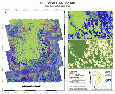 One of the greatest threats to the Amazon rainforest is the rapid expansion of industrial agriculture, and rates of deforestation are likely to increase in the coming decades as demands for biofuel and animal feed increase. Scientists at the Woods Hole Research Center are actively involved in the development of policy mechanisms focused on compensating rainforest nations for slowing deforestation, thereby reducing their emissions from heat-trapping greenhouse gases. As part of this effort, Dr. Josef Kellndorfer and his colleagues are investigating the latest spaceborne remote sensing technologies for monitoring tropical deforestation, including a new Japanese radar sensor, the Phased Array L-Band Synthetic Aperture Radar (PALSAR), carried on board the Advanced Land Observing Satellite. Using data from the ALOS/PALSAR, Dr. Kellndorfer’s group has produced the first-of-its-kind, large-scale, wall-to-wall image mosaic for a portion of the Amazon basin (see A above). Launched in 2006, the ALOS/PALSAR will deliver annual pan-tropical image acquisitions over short time frames (~3 months) and through dense cloud cover and precipitation. These characteristics make ALOS data ideally suited for reducing current uncertainties associated with quantifying forest loss and agricultural expansion (see B and C above) across the tropics. Credit: Josef Kellndorfer/Wayne Walker, The Woods Hole Research Center (whrc.org) |
The image mosaic is a composite of 116 individual scenes acquired over the Xingu basin in Mato Grosso, Brazil, between June 8 and July 22, 2007 by the Phased Array L-Band SAR carried on board the Japanese Advanced Land Observing Satellite (ALOS). WHRC researchers led by Dr. Josef Kellndorfer used the mosaic to generate a preliminary land cover classification map. The data is also being investigated to determine differences in aboveground biomass (i.e. carbon) in collaboration with the Amazon Institute of Environmental Research (IPAM).
“The area that is mapped with the mosaic of images centers on the headwaters of the Xingu River, one of the Amazon’s mighty tributaries. The indigenous groups, soy farmers, smallholders, and ranchers that live in this region are top candidates to receive payments for reducing their carbon emissions. Where this has previously taken us several months to prepare, this new mosaic took only a few days, a turnaround window that carries real significance.” said Woods Hole Research Center senior scientist Daniel Nepstad.
The researchers say remote sensing systems will play a critical role in the development of REDD (Reduced Emissions from Deforestation and Degradation) mechanisms that seek to compensate tropical forest nations for avoiding and reducing deforestation. Deforestation presently accounts for roughly 20 percent of anthropogenic greenhouse gas emissions.