Real-time satellite tracking of fires in Madagascar could help protect lemurs, forests
Real-time satellite tracking of fires in Madagascar could help protect lemurs, forests
mongabay.com
October 29, 2007
Madagascar fires mapped with Google Earth in real-time
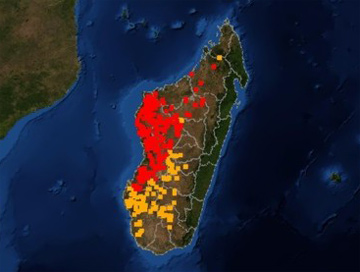
Every year as much as one-third of Madagascar, one of the planet’s most biodiverse islands, goes up in flames. Now a new tool gives scientists the ability to monitor and track Madagascar’s fires in real-time through the Internet.
Madagascar is world-famous for its lemurs, a diverse group of primates that are endemic to the Indian Ocean island nation. Madagascar is also known for widespread bush fires that are usually set by farmers and cattle herders seeking to clear land for subsistence agriculture or promote the growth of new vegetation for animal fodder. These fires sometimes escape scrub areas and spread into parks and endangered forest areas.
While the Malagasy government has tried to crack down on burning, the lack of an effective monitoring system has made it difficult to track fires and keep them from spreading. The new Fire Alert System — a collaborative effort between Madagascar’s ministry of Environment, the International Resources Group, and Conservation International with USAID funding — allows anyone with an Internet connection to see where fires are burning. The system includes email alerts that notify subscribers when a fire has been detected in a specified area.
 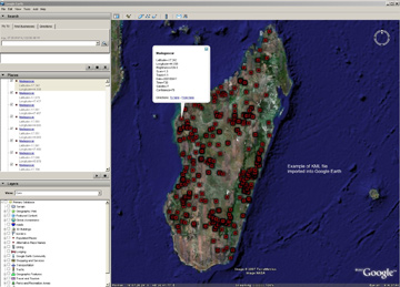 Data from the Fire Alert System can be viewed using Google Earth |
“The Fire Alert System gives access to fire data with fine resolution land cover data to email subscribers by creating notifications ranging from text-based emails with GPS coordinates to GIS shapefiles and custom images of fires occurring within key administrative units and biologically important areas,” explained Leanne Miller, Spatial Data Manager at Conservation International in Arlington, Virginia. “This information can be used for fire management or response by government, local NGOs, and partners.”
The Fire Alert System, which uses the Moderate Resolution Imaging Spectroradiometer (MODIS) on NASA’s Terra and Aqua satellites, is capable of detecting a fire in an area as small as 50 square meters and providing precise geographical data for the fire’s location.
Beyond providing information on fires in areas of high biological importance, the system can be used to alert populations of imminent threats from bush fires. All information from the system and the web site (http://firealerts.conservation.org) is available in both French — widely spoken in Madagascar — and English.
Miller says that while the system is currently focused exclusively on Madagascar, with the help of the Fire Information for Resource Management System (FIRMS) at the University of Maryland, it will be expanded to new regions in the future.
http://firealerts.conservation.org
Related
Fire monitoring by satellite becomes key conservation tool
Remote sensing is increasingly used as a tool for conservation management. Beyond traditional satellite imagery popularized by Google Earth, new sensing applications are allowing researchers located anywhere in the world to track fires, illegal logging and mining, and deforestation in some of Earth’s most isolated regions using a computer or handheld device.