Arctic sea ice melts to all-time record low
Arctic sea ice melts to all-time record low
mongabay.com
September 12, 2007
Sea ice cover in the Arctic Ocean is presently 20 percent below its all time lowest extent and may decline further before winter, said scientists from the National Snow and Ice Data Center in Boulder (NSIDC).
“It’s almost an exclamation point on the pronounced ice loss we’ve seen in the past 30 years,” Mark Serreze, a senior research scientist at NSIDC, told CNN.
Satellite data shows that the Arctic ice pack covers 4.24 million square kilometers (1.63 million square miles). The previous record low of 5.32 million square kilometers (2.05 million square miles) was set in September 2005.
The Arctic is particularly sensitive to changes in the extent of sea ice, which helps reflect sunlight back into space, cooling the region. When sea ice melts, the dark areas of open water absorb the sun’s radiation, trigger a positive feedback loop that worsens melting.
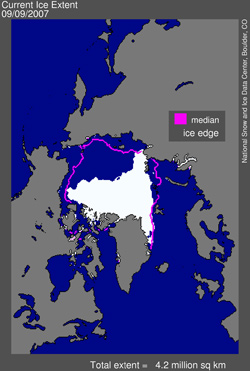 Figure 1 provides the updated map of sea ice extent for September 9, 2007. Sea ice extent now stands at 4.24 million square kilometers (1.63 million square miles). The magenta line shows the median September monthly extent based on data from 1979 to 2000. |
Scientists now say that the Arctic could lose all its summer sea ice by 2030, a development that would have implications for wildlife — like polar bear and walrus — that depend on pack ice for feeding.
The disappearance of sea ice will also have economic consequences. The summer several countries — including Canada, Russia, the U.S., Denmark, Sweden and Norway — sent expeditions to the Arctic in an effort to bolster claims for the region’s rich mineral and gas resources. Melting sea ice has already opened a “Northwest Passage” between the Atlantic and Pacific Oceans.
This article used information from CNN and previous mongabay.com posts.