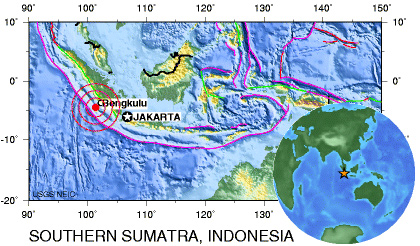
8.4 magnitude earthquake triggers tsunami in Indonesia
8.4 magnitude earthquake triggers tsunami in Indonesia
mongabay.com
September 12, 2007
An 8.4 magnitude earthquake struck Indonesia Wednesday at 6:10 pm local time. The epicenter was located 130 km (80 miles) southwest of Bengkulu, Sumatra and 620 km (385 miles) west-northwest of Jakarta at a depth of 30 km (18.6 miles). The earthquake was followed by a series of aftershocks — the strongest of which registered at a magnitude of 6.6.
A 3-foot tsunami was recorded in Padang, on the island of Sumatra, several hundred miles northeast of the epicenter, according to Suhardjono, an official with Indonesia’s meteorological agency, reports the Associated Press.
Initial reports suggest seven people were killed and more than 200 were injured.
In December 2004, a quake off Sumatra triggered a tsunami that killed more than 230,000 people, including 160,000 people in Indonesia’s province of Aceh. That quake was nearly 10 times as powerful as Wednesday’s quake. The city of Yogyakarta was hit by a powerful quake that killed more than 5,700 just over a year ago.
 Image modified from USGS |
Last December scientists from the University of Southern California (USC) and California Institute of Technology (Caltech) warned that Indonesia could be due for another large tsunami like the one that devastated the island on December 26, 2004.
The Indian government issued a tsunami alert for the Andaman and Nicobar islands, which were hard hit by the 2004 tsunami. Kenya, Tanzania, Thailand, and the Seychelles also issued tsunami warnings. The Indonesian government lifted its tsunami warning two hours after the Wednesday tremor.
Update: A second powerful quake struck 125 miles from Bengkulu at 6:49 am local time on September 13. The 7.8 magnitude quake was centered at a depth of 6 miles and Indonesia issued a third tsunami warning.