U.S. government weather agency cuts hurricane outlook
U.S. government weather agency cuts hurricane outlook
mongabay.com
August 6, 2007
The U.S. National Oceanic and Atmospheric Administration on Thursday reduced its forecast for the number of tropical storms and hurricanes expected during the 2007 Atlantic season. NOAA said it now expected between 13 and 16 named storms, with seven to nine becoming hurricanes and three to five of them classified as “major” hurricanes (categories 3, 4, or 5).
The predictions come a week after hurricane researcher William Gray from Colorado State University also cut his 2007 hurricane season outlook. He said that weak La Niña conditions and more atmospheric dust from Africa, signifying a generally stable air mass over the tropical Atlantic, would mean there will likely be fewer storms than previously projected
Gray and his colleague Philip J. Klotzbach said they expected 15 named storms and eight hurricanes — four of which would be intense — in the Atlantic basin during the 2007 hurricane season. The new estimates come two weeks after private forecaster WSI Corp reduced its projections to 14 named storms, of which six will become hurricanes and three will become major hurricanes.
Overall the Colorado State University say there is a 68 percent chance that at least one major (Category 3, 4, or 5) hurricane will hit the entire U.S. coastline during the 2007 season. The average for the last century was 52 percent. The probability of such a storm hitting the U.S. East Coast is about equal to that of it hitting the Gulf Coast, according to the researchers.
The predictions are still well above average for the past century.
Hurricanes and climate change
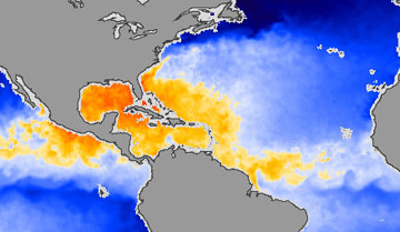 This image shows sea surface temperatures in the Atlantic Ocean and the Gulf of Mexico on July 26, 2007. Water that is warm enough to fuel hurricanes is yellow, orange, and red, while water that is too cool to sustain a hurricane is blue. The relatively shallow Gulf of Mexico and the Caribbean were warm and hurricane-ready. Hurricane Alley, the warm swath of water between Africa and the northern tip of South America where hurricanes frequently form, was just beginning to heat up. The image was made from data collected by the Advanced Microwave Scanning Radiometer (AMSR-E) flying on NASA’s Aqua satellite. Caption courtesy of NASA |
Gray has long argued that the recent up tick in hurricane activity is due to natural cycles rather than climate change, a position contested by other climate scientists who say that climate linked warmer ocean temperatures are triggering stronger and more frequent storms.
“Some scientists, journalists and activists see a direct link between the post-1995 upswing in Atlantic hurricanes and global warming brought on by human-induced greenhouse gas increases. This belief, however, is unsupported by long-term Atlantic and global observations.” wrote Gray in an Wall Street Journal editorial published July 26, 2007. “My Colorado State University colleagues and I attribute the increase in hurricane activity to the speed-up of water circulating in the Atlantic Ocean. This circulation began to strengthen in 1995 — at exactly the same time that Atlantic hurricane activity showed a large upswing.”
“The warming theorists… have the ears of the news media. But there is another plausible explanation, supported by decades of physical observation,” he continued. “The spate of recent destructive hurricanes may have little or nothing to do with greenhouse gases and climate change, and everything to do with the Atlantic Ocean’s currents.”
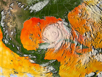 Warm ocean waters fuel hurricanes, and there was plenty of warm water for Katrina to build up strength once she crossed over Florida and moved into the Gulf of Mexico. This image depicts a 3-day average of actual sea surface temperatures (SSTs) for the Caribbean Sea and the Atlantic Ocean, from August 25-27, 2005. Every area in yellow, orange or red represents 82 degrees Fahrenheit or above. A hurricane needs SSTs at 82 degrees or warmer to strengthen. The data came from the Advanced Microwave Scanning Radiometer (AMSR-E) instrument on NASA’s Aqua satellite. The GOES satellite provided the cloud data for this image. Image Credit: NASA/SVS. |
A study published shortly after Gray’s editorial argued the opposite. Writing in Philosophical Transactions of the Royal Society of London, Greg Holland of the National Center for Atmospheric Research (NCAR) and Peter Webster of Georgia Institute of Technology tied the recent doubling of Atlantic hurricane activity to changes in climate.
Analyzing hurricane records over the past 100 years, Holland and Webster report that increases in hurricane frequency over the last century correlate closely with sea surface temperatures. They note that other studies show that most of the rise in Atlantic sea surface temperatures can be attributed to global warming.
“These numbers are a strong indication that climate change is a major factor in the increasing number of Atlantic hurricanes,” said Holland.
Related articles
Global warming is causing stronger Atlantic hurricanes finds new study — 3/1/2007
Global warming is fueling stronger hurricanes according to a new Geophysical Research Letters study that revises that database of historic hurricanes. Previously the hurricane database was considered inconsistent for measuring the record of tropical storms since there have been significant improvements in the technology to measure storms since recording-keeping began. Before the development of weather satellites, scientists relied on ship reports and sailor logs to record storms. The advent of weather satellites in the 1960s improved monitoring, but records from newer technology have never been squared with older data. The new study normalizes the hurricane record since 1983.
Caves may reveal if global warming is causing stronger hurricanes — 1/29/2007
Scientists have shown that cave formations could help settle the contentious debate on whether hurricanes are strengthening in intensity due to global warming. Measuring oxygen isotope variation in stalagmites in Actun Tunichil Muknal cave in central Belize, a team of researchers have identified evidence of rainfall from 11 tropical cyclones over a 23 year period (1978-2001). The research — the study of ancient storms is called paleotempestology — could help create a record of hurricanes that would help researchers understand hurricane frequency and intensity. “Tropical cyclones (including hurricanes, tropical storms, typhoons, and cyclones) produce rainwater that is different from other summertime precipitation,” explained Amy Benoit Frappier, an assistant professor in the Department of Geology and Geophysics at Boston College and lead author of the study published in Geology. “Tropical cyclones produce isotopically light rainwater primarily because 1) their cloud tops are very high and cold, and 2) their humid air tends to prevent lighter water molecules from evaporating back out of the raindrop as they fall.”
Tree rings could settle global warming hurricane debate — 9/20/2006
Scientists have shown that ancient tree rings could help settle the debate as to whether hurricanes are strengthening in intensity due to global warming. By measuring different isotopes of oxygen present in the rings, Professors Claudia Mora and Henri Grissino-Mayer of the University of Tennessee have identified periods when hurricanes hit areas of the Southeastern United States up to 500 years ago. The research could help create a record of hurricanes that would help researchers understand hurricane frequency and intensity. Currently reliable history for hurricanes only dates back a generation or so. Prior to that, the official hurricane records kept by the National Oceanic and Atmospheric Administration’s Atlantic basin hurricane database (HURDAT) are controversial at best since storm data from more than 20 years ago is not nearly as accurate as current hurricane data due to improvements in tracking technology. The lack of a credible baseline makes it nearly impossible to accurately compare storm frequency and strength over the period.
This article is an updated version of an earlier mongabay.com article.