Contrary to popular belief, the Amazon rainforest is not rainy year round. Further from the equator, rainfall is more seasonal, with dry periods that sometimes last for months.
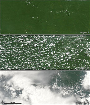 This trio of photo-like images illustrates steps in the initiation of the wet season in the southern Amazon in 2006. Captured by the Moderate Resolution Imaging Spectroradiometer (MODIS) on NASA’s Aqua satellite, they show a progression from mostly clear skies on August 7, to popcorn-like, scattered cumulus clouds on August 25, to more widespread thunderstorm activity on September 3. During the less-cloudy dry season, the team of scientists discovered, the ratio of leaf area to ground area across the Amazon rises up to 25 percent compared to the annual average. The increase in leaf area could explain a previously documented surge in evapotranspiration (the release of water vapor from vegetation) that precedes the arrival of the full-blown rainy season in a given part of the Amazon. The increase in water vapor makes the air above the forest more buoyant than dry air. The buoyant air and water vapor rise and cool, forming clouds. The energy released as water vapor condenses into clouds helps build thunderstorms. As thunderstorms become more widespread and intense, they transfer large amounts of heat to upper layers of the atmosphere. This elevated heating causes the entire atmospheric circulation in the area to reverse directions, drawing in air and moisture that maintain the seasonal rains. NASA images and caption text courtesy the MODIS Rapid Response Team, Goddard Space Flight Center |
In the Southern Amazon, a region that has suffered the brunt of deforestation due to clearing for cattle pasture and agriculture, April or May mark the beginning of the dry season. Rains usually return in September or October, though in recent years, dry seasons have been prolonged, with increasingly severe impacts on the forest ecosystem. In 2005 and 2006 the Amazon experienced the worst droughts on record as thousands of square kilometers of land burned for months on end, releasing more than 100 million metric tons of carbon into the atmosphere. As rivers dried up, remote communities were isolated while commerce slowed to a standstill.
2007 is shaping up to be a similar year with meteorologists forecasting conditions akin to those seen in 2005: warming in the tropical North Atlantic (the same conditions that influence hurricane formation in the Caribbean and East Coast of the United States). Another year of drought is of great concern to researchers studying the Amazon ecosystem. Field studies by the Massachusetts-based Woods Hole Research Center suggest that Amazon forest ecosystems may not withstand more than two consecutive years of drought without starting to break down. Severe drought weakens forest trees and dries leaf litter leaving forests susceptible to land-clearing fires, which, in turn, produce smoke that hinders the formation of rain clouds. Logging and deforestation only worsen the effects, which can lead to a feedback cycle that further dries the forest.
“Fires set by landholders to control weeds in their pastures or to burn recently felled forest in preparation for planting often escape beyond their intended boundaries,” explains the Woods Hole Research Center. “Undisturbed forests are resistant to burning because their dense leaf canopy prevents all but a tiny portion of incoming solar radiation from reaching the forest interior, keeping the litter layer too moist to sustain a fire. Now large areas of forest are selectively logged prior to being settled, leaving holes in the canopy; longer, more intense dry seasons provoke leaf thinning; and both of these changes allow the litter to become dry enough to sustain a fire. Once a forest has burned a first time, the combination of a more damaged forest canopy and a stock of larger fuel from trees killed by prior fires make it even more vulnerable to subsequent fires.”
Simulations by scientists from Woods Hole and other institutions suggest that 40 percent of the Amazon could be lost by 2050. Climate change, which may increase temperatures in the basin by as much as five degrees Celsius (eight degrees F), could exacerbate the loss.
“The threat of a “permanent El Niño” is therefore to be taken very seriously,” said Dr. Philip M. Fearnside of the National Institute for Research in the Amazon (INPA) in an interview with mongabay.com last year. “Again, it depends on how seriously society takes the problem to be. If fossil-fuel combustion and deforestation are reduced to reflect the importance of the problem, then the worst could be avoided. If this does not happen, the danger of a “runaway greenhouse” escaping from human control becomes much greater. Disintegration of the Amazon forest, with release of the carbon stocks in the biomass and soil, would be a significant factor in pushing us into a runaway greenhouse.”
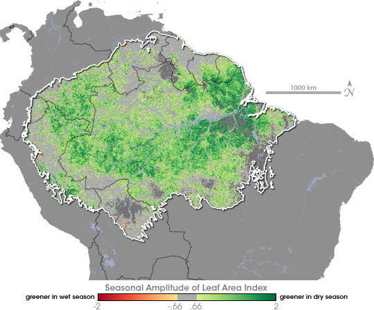 This image shows seasonal shifts in the leaf area of the Amazon based on data collected by the Moderate Resolution Imaging Spectroradiometer (MODIS) on NASA’s Terra satellite. NASA map by Robert Simmon, based on MODIS data from the Boston University Climate and Vegetation Research Group.
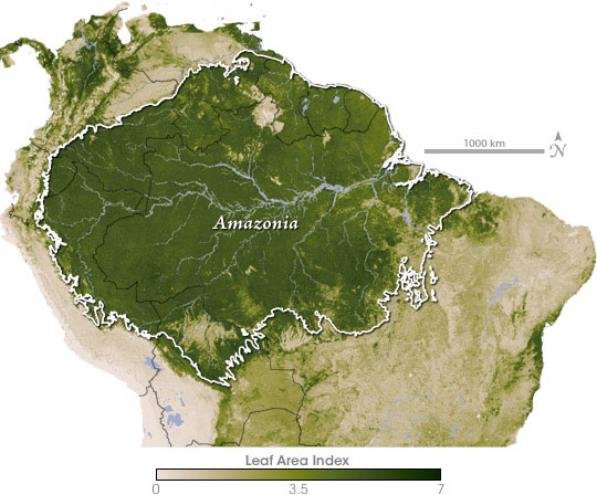
The map above is a multi-year average of the leaf area index of the Amazon based on Terra MODIS data. Leaf area index is the ratio of the leaf surface area to ground surface area. Values above 1 indicate multiple overlapping leaves, like the multi-tiered branches of a tree’s crown or multiple layers of vegetation. Not surprisingly, leaf area index is high throughout the Amazon (dark green), tapering off (light green) in the savannas and grasslands to the south, where vegetation is more sparse. The Andes to the west are almost completely barren (beige). NASA map by Robert Simmon, based on MODIS data from the Boston University Climate and Vegetation Research Group. More at The Amazon’s Seasonal Secret. |