Remote sensing tools used to predict bird species richness
Remote sensing tools used to predict bird species richness
Woods Hole Research Center
May 14, 2007
Scientists at the Woods Hole Research Center, NASA Goddard Space Flight Center and the University of Maryland have taken a novel approach to studying biological diversity by making use of laser remote sensing (lidar). Lidar data provide unique measurements of the 3-dimensional structure of vegetation, an important aspect of habitat diversity. Habitat heterogeneity and complexity have been shown in many places to be directly related to animal species richness — a more complex environment provides a greater number of ecological niches to be filled by different species. Using this basic principle, WHRC scientists examined the relationships between bird species richness and habitat metrics derived from lidar data acquired by aircraft. They then explored the efficacy of predicting bird richness and abundance based on these metrics. The first phase of this research, profiled in the current issue of Remote Sensing of Environment, focuses on results from study sites in the Patuxent Wildlife Refuge in Maryland.
According to Scott Goetz, a senior scientist at the Center who is leading the project, “Lidar is the most unique and exciting technology to come along in the past decade in the remote sensing research community. We now have the ability to characterize vegetation in three dimensions, and that has implications not only for biodiversity research but also for improved estimates of biomass and carbon stocks.”
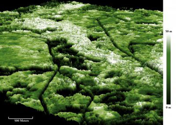 This 3-dimensional image shows forest canopy height in the Patuxent National Wildlife Refuge, as derived from lidar data acquired from aircraft in 2003. Dark colors (dark green to black) represent areas with low-lying or no vegetation, whereas lighter colors show areas with a taller trees. The corridor meandering through the center of the image includes mostly tall trees — some in excess of 40m (130 foot) height — along the Big Patuxent river. Credit: Daniel Steinberg, Woods Hole Research Center |
While some recent studies that have assessed the utility of satellite remote sensing for mapping aspects of biological diversity, they have relied solely optical imagery, particularly LandSat, to characterize horizontal variability in habitat, such as the mixture of different land cover types. Utilizing lidar provides information in the vertical dimension, that is, in the terms of canopy profiles describing the vertical distribution of canopy elements, like leaves and branches. This information is then translated into canopy metrics for every lidar “shot” that penetrates through the canopy. Using this information, researchers can estimate bird diversity through its link with habitat diversity. In the Patuxent study, the lidar metrics were consistently better predictors of biodiversity than those based on the use of LandSat imagery.
Daniel Steinberg, a research assistant who is working on the project, adds, “The instrument we use to acquire the lidar data, known as the Laser Vegetation Imaging Sensor (LVIS), collects literally millions of data points within a small area, and using this data we can actually construct 3-dimensional images of canopy height, elevation, complexity, as well as other metrics of habitat structure.”
The study sites in Patuxent Wildlife Refuge were chosen because collaborators in the project had estimated bird species richness across a regular grid, giving the scientists a basis for comparison. This work is currently being extended to the Hubbard Brook LTER (Long Term Ecological Research) site in New Hampshire to explore how well lidar data can aid predictions of the abundance of birds that are habitat specialists – like those that use (for either foraging or nesting) more vertically complex canopies versus shrubs or open areas — particularly neotropical migrants that rely on U.S. forests for summer habitat.
Dr. Goetz adds, “We have known for years that habitat diversity is important for many aspects of biological diversity, but it was never before possible to acquire data on habitats over very large areas. With the advent of lidar, particularly on a satellite platform planned for the near future, we will have a valuable new tool for identifying and protecting key biodiversity hotspots — while also gathering critical information needed to map and monitor changes in carbon stocks.”
This is a modified news release from the Woods Hole Research Center