Fires burn across Burma; pollution levels rise in Thailand
Fires burn across Burma; pollution levels rise in Thailand
mongabay.com
March 20, 2007
Fires are raging across Myanmar (Burma) causing “haze” pollution in neighboring Thailand, Laos, and southern China according to new satellite images release by NASA.
The fires are set annually during the dry season for clearing brush and scrub for agriculture. In especially dry years the fires often spread into adjacent forest areas.
Images captured by the Moderate Resolution Imaging Spectroradiometer (MODIS) on NASA’s Aqua satellite show fire activity on March 19, 2007 across eastern India, Myanmar, Thailand, Laos, and China. Fires are denoted with red dots while forest areas are dark green and agricultural zones are light green to tan. The NASA images reveal lots of smoke from the fires.
Myanmar has the fourth highest annual loss of forest cover, according to figures released by the United Nations. Between 2000 and 2005, the country lost an average of 466,000 hectares of forest per year. While logging is heavy in parts of the country, most deforestation results from clearing for agriculture.
Haze from the fires has caused air quality to plummet in Thailand. Last year haze from widespread fires in Indonesia, especially on the islands of Borneo and Sumatra, blanketed Thailand and Malaysia.
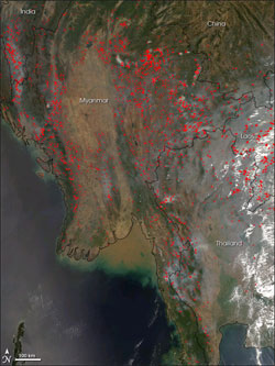 This image from the Moderate Resolution Imaging Spectroradiometer (MODIS) on NASA’s Aqua satellite shows fire activity on March 19, 2007, across eastern India, Myanmar, Thailand, Laos, and China. Places where MODIS detected actively burning fires are marked in red on the image. The darker green areas are generally more wooded areas or forests, while the paler green and tan areas are agricultural land. Smoke pools over low-lying areas of the hilly terrain in gray pockets. The green tops of rolling hills in Thailand emerge from a cloud of low-lying smoke. NASA image created by Jesse Allen, using data provided courtesy of the MODIS Rapid Response team. Caption text provided by NASA |