Antarctic subglacial lakes plumbed by satellite
Antarctic subglacial lakes plumbed by satellite
mongabay.com
February 15, 2007
The discovery of a network of rapidly filling and emptying lakes lying beneath at least two of West Antarctica’s ice streams suggests that change in the Antarctic could be more rapid than previously believed, according to a team of scientists writing in Friday’s edition of the journal Science.
“We didn’t realize that the water under these ice streams was moving in such large quantities, and on such short time scales,” said Helen Fricker of the University of California San Diego’s Scripps Institution of Oceanography and lead author of the study. “We thought these changes took place over years and decades, but we are seeing large changes over months. The detected motions are astonishing in magnitude, dynamic nature and spatial extent.”
“We’ve found that there are substantial subglacial lakes under ice that’s moving a couple of meters per day. It’s really ripping along. It’s the fast-moving ice that determines how the ice sheet responds to climate change on a short timescale,” said Robert Bindschadler of NASA’s Goddard Space Flight Center and one of the study’s coauthors. “We aren’t yet able to predict what these ice streams are going to do. We’re still learning about the controlling processes. Water is critical, because it’s essentially the grease on the wheel. But we don’t know the details yet.”
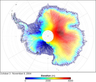 Launched January 12, 2003, NASA’s Ice, Cloud, and land Elevation Satellite, or ICESat, is designed to measure the mass balance of Earth’s ice sheets (balance between processes that add ice to the ice sheets versus processes that remove ice), the height of clouds and aerosols, and the topography of the land. The colors on the map above represent ICESat’s measurements of Antarctica’s topography, using data collected from October 3 through November 8, 2004. Red shows the highest elevations (up to 4,000 meters above sea level). Yellow, green, and turquoise show progressively lower elevations (green is 2,000 meters above sea level). Dark blue shows sea level. NASA image (top) courtesy Christopher Shuman, ICESat Deputy Project Scientist, Goddard Space Flight Center. Caption text courtesy of NASA. |
Scientists have long known that water exists under ice streams, but this is the first observation of a system of subglacial water storage reservoirs below fast-moving ice. The researchers say that understanding the behavior of these ice streams is critical for developing models to predict how melting in Antarctica may contribute to sea level rise.
The findings are based on data from NASA’s Ice Cloud and land Elevation Satellite (ICESat) which is equipped with an altimeter instrument that can detect changes in the ice sheet surface elevation as small as 1.5 centimeters (0.6 inches) from nearly 645 kilometers (400 miles) above Earth.
“I’m quite astonished that with this combination of satellite sensors we could sense the movement of large amounts of water like this. From 600 kilometers up in space, we were able to see small portions of the ice sheet rise and sink,” added Bindschadler. “Until now, we’ve had just a few glimpses into what’s going on down there. This is the most complete picture to date what’s going on beneath fast flowing ice.”
“The approach used for this work provides glaciologists with a new tool to survey and monitor the nature of the subglacial water system and to link these observations to the motion of the ice sheet,” Fricker said. “We still don’t know how the subglacial water system varies on longer time-scales from decades to centuries. To do this, we need to continue monitoring the ice streams with ICESat and future follow-on missions.”
Authors of the article also include Ted Scambos of the National Snow and Ice Data Center and Laurie Padman of Earth & Space Research.
This article is based on news releases from NASA, AAAS, and the University of California San Diego.