New satellite maps show forest loss and degradation
Rhett A. Butler, mongabay.com
March 22, 2006
Greenpeace today launched a set of satellite maps showing the world’s remaining extent of “intact forests”—the planet’s most biodiverse ecosystems.
Intact forests, defined by the environmental organization as blocks of forest landscapes larger than 500 square kilometers that have not fragmented by infrastructure, such as roads, human settlements, waterways, pipelines, and power lines, today cover less than 10% of the earth’s land area.
Greenpeace found that remaining intact forests are distributed as follows: 35 percent in Latin America, 28 percent in North America, 19 percent in Northern Asia, 8 percent in Africa, 7 percent in South Asia Pacific, and less than 3 percent in Europe. Greenpeace says that much of the large intact forest landscapes have already been cut down and estimates that 82 countries out of 148 countries lying within the forest zone have lost all their intact forest landscapes.
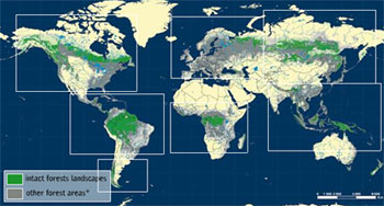 Intact forests map. Courtesy of Greenpeace. |
Greenpeace says that protecting these last intact forests should be a top priority for world governments at the biodiversity meeting in Brazil this week and hopes these maps can serve as a starting point for monitoring and conservation efforts.
“Forest loss has a direct link to loss of biodiversity. The current extinction rate of plant and animal species is around 1,000 times faster than in pre-human times — and this will increase to 10,000 times faster by 2050. Scientists predict that the Earth is entering the sixth major extinction event in its history.This is the first one to occur because of human activity,” Greenpeace said in a statement.
“Until now, world maps have not been sufficiently accurate or consistent to reveal which forest areas remain intact, which have been damaged and to what extent. This has made it difficult to see which forest areas are most in need of protection.”
Greenpeace says its new map, based on current high-resolution satellite imagery and a consistent set of criteria, “shows us the remaining large forest areas and lets us compare them directly and accurately, for the first time. This ground breaking research shows that the world’s remaining ancient forests are in crisis and … to save them, we must act now.”
The new maps can be viewed at www.greenpeace.org/forestmaps