Climate change increases California flood, drought risk
Rhett A. Butler, mongabay.com
February 7, 2006
Climate change may increase the risk of winter floods and summer water shortages—even within the same year—says new research by scientists Lawrence Livermore National Laboratory (LLNL).
The study, which appeared in the January 27 edition of the journal Geophysical Research Letters shows that global warming is likely to change river flows in ways that may result in both increased flood risk and water shortages.
As temperatures warm as a result of global carbon emissions, more rain than snow falls at higher elevations. In areas that do receive snow, melt occurs sooner increasing wintertime river flows while reducing the availability of water for spring and summer flows. Further, this scenario could be more severe in El Niño years, which generally feature warmer winters and produce higher amounts of precipitation.
According to the scientists, since rainfall in California occurs over a short seasonal interval, California’s water infrastructure is dependent on the build up of snow in the mountains of the Sierra Nevadas. Snow acts as a natural reservoir by releasing water into streams and man-made reservoirs after winter and early spring rains and snowfall have ceased.
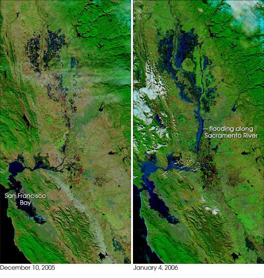 This pair of images shows flooding in the Sacramento-San Joaquin Valley region inland of San Francisco Bay. The image on the left was captured by the Moderate Resolution Imaging Spectroradiometer (MODIS) on NASA’s Aqua satellite on December 10, 2005, while the image at right was captured on January 4, 2006, just days after the severe storms passed through. Dark blue pools of water swamp far larger areas of ground in January than they did in December. The Sacramento River is very wide and turbid; the sediment in the water is reflective and gives the river its lighter blue appearance. The northern reaches of San Francisco Bay are also bright with sediment, which may be a mixture of river run-off and churning of the Bay by storm winds. Vegetation is bright green, snow in the Sierra Nevada Mountains is bright blue (upper right), and bare or sparsely vegetated ground appears pinkish or reddish tan. Courtesy of MODIS Rapid Response Team, Goddard Space Flight Center (NASA) |
Warmer temperatures may cause California’s rivers to carry a heavier flow during wet months, possibly triggering floods like those seen this past winter in Napa, Marin, and the Sacramento Central Valley. During summer months, river flows would be much reduced, resulting in water shortages that could affect California’s rich agricultural areas. The net effect of climate change could be extreme shifts in California’s water supply.
“Even if total flows over the whole year are the same, these changes could jeopardize water supplies, because it may not be possible for reservoirs to capture the increased winter flows,” said Edwin Maurer, a professor at Santa Clara University and lead author of the research. “This problem would be compounded by an increased risk of wintertime flooding resulting from higher river flow rates,” he said.
Related news
6.5 earthquake could cut off California’s water supply
Appearing before a joint legislative committee, Department of Water Resources (DWR) Director Lester Snow today outlined the catastrophic impact a significant earthquake would have on Delta levees. He said failed levees would cause major floods, threaten public safety, damage the water supply infrastructure, and jeopardize the State’s economy. The DWR scenario is based on a 6.5 magnitude earthquake on a fault under the west Delta. Scientific models suggest the quake could produce more than 30 levee breaches on 16 Delta islands.
25% probability of 7.0 earthquake hitting San Francisco by 2025
There’s at least a 25% chance of a magnitude 7.0 or greater quake occurring during the next 20 years in the San Francisco Bay Area according to a new computer simulation by researchers at the University of California, Davis. The research is presented in this week’s edition of the Proceedings of the National Academy of Sciences.
Hurricane could hit San Diego
San Diego has been hit by hurricanes in the past and may be affected by such storms in the future according to data from the National Oceanic and Atmospheric Administration (NOAA). While a hurricane in San Diego would likely produce significantly less damage than Hurricane Katrina in New Orleans, it could still exact a high cost to Southern California especially if the region was caught off guard.
This article is based on a news release from the Lawrence Livermore National Laboratory.