Amazon drought continues, worst on record
Rhett A. Butler, mongabay.com
December 11, 2005
The worst drought ever recorded in the Amazon continues according to an update from The New York Times. The drought has turned rivers into grassy mud flats, killed tens of millions of fish, stranded hundreds of communities, and brought disease and economic despair to the region.
Back in October, Brazil declared a state of emergency in the state of Amazonas due to record low water levels. Since then, little rain has fallen and the situation has worsened. According to The New York Times, the Brazilian Armed Forces have mounted the largest relief operation in their history, delivering some 2,000 tons of food and 30 tons of medicine to affected communities just in the region.
Scientists are not certain as to the cause of the drought, although warmer water temperatures in the Atlantic Ocean are the leading suspect. This year, some researchers believe that the accumulation of warm waters in the tropical Atlantic helped fuel a record hurricane season while reducing the availability of moisture to the Amazon basin. These conditions are likely to worsen as global temperatures increase.
Research published last week suggests warmer sea temperatures in the tropical Atlantic are likely to become increasingly prevalent as currents that normally carry warm water from equatorial regions towards the Arctic weaken. One simulation by researchers at the University of Illinois, Urbana-Champaign, found that 45 percent chance that existing water currents in the North Atlantic Ocean could shut down by the end of the century if nothing is done to slow greenhouse gas emissions. Such a collapse of the so-called “Atlantic heat conveyor belt” could plunge parts of Europe into significantly colder winters while exacerbating drought conditions in equatorial Africa. Back in the Amazon, the usually moist rainforest could become drier and more susceptible to forest fires.
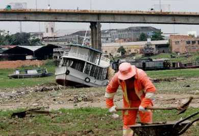
 A municipal worker cleans up garbage left behind by the receding Rio Negro river, one of the two biggest tributaries of the Amazon River, as boats remain stranded during the region’s worst drought in decades, in the port of Manaus, capital of Brazil’s Amazonas State, October 7, 2005. Drought in the Amazon rain forest, normally one of the world’s wettest regions, shows the weather cycle is swinging to one extreme rather than signaling climate change, local meteorologists said Thursday. REUTERS/RICKEY ROGERS |
Some local officials believe deforestation may also be playing a role in the drought. Forest clearing impacts rainfall by disrupting the local water cycle. Under normal conditions, forests add to local humidity through transpiration — the process by which plants release water through their leaves. Moisture is transpired and evaporated into the atmosphere where it contributes to the formation of rain clouds. Scientists estimate that 50-80% of the moisture in the central and western Amazon remains in the ecosystem water cycle. However, when forests are cut, as is occurring in Brazil and upper parts of the Amazon watershed in Peru, less moisture is evapotranspired into the atmosphere, resulting in the formation of fewer rain clouds and less rainfall.
There is further concern that drought and low water conditions will only worsen in coming years as more forest is cleared and glaciers in the Andes continue to retreat. Glaciers, which are the source for as much as 50% of the water in the upper Amazon, are fast disappearing in Peru. According to a 1997 study by the Peruvian government, the country’s glaciers have shrunk by more than 20% in the past 30 years. Further, the National Commission on Climate Change in Lima projects that Peru will lose all its glaciers below 18,000 feet in elevation in the next decade and possibly all its glaciers within the next 40 years. The impact on the Amazon, when combined with deforestation, could be devastating to the region’s climate, water cycle and economy.
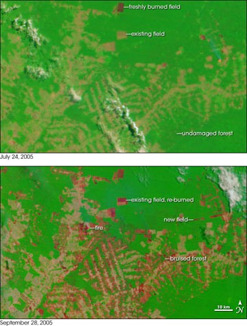
 In the state of Acre in western Brazil, farms and pastures are surrounded by large, undisturbed areas of Amazon Rainforest. Since January 2005, many areas in the state have been experiencing severe drought, and the forests have become tinder dry. Since August, agricultural fires—many of them ignited in violation of a state-declared ban—have been escaping control, racing through adjacent fields and spreading into the forests. The situation deteriorated through September, and record amounts of previously undamaged rainforest may burn before the episode is over. Several NASA-funded scientists have helped the Brazilians respond to the disaster by providing daily summaries of fire detections made by satellite, aircraft, and ground observations. These images from the Moderate Resolution Imaging Spectroradiometer (MODIS) on NASA’s Terra satellite shows a pattern of forest and farmland east of the city of Rio Branco before (top) and after (bottom) the peak of the 2005 agricultural burning season. The images are made from visible, shortwave, and near-infrared light detected by MODIS. Bright green is unburned forest, bright red is recently burned areas, and tan is cleared, but unburned land. Next to some burned fields, the forest appears dark green, or “bruised,” probably indicating places where fires escaped from fields and burned into the forest understory. [NASA images by Jesse Allen (NASA Earth Observatory)and Jeff Schmaltz (MODIS Rapid Response)] |
In the meantime communities in the Amazon will continue to struggle with the misery and isolation that low water conditions bring. The New York Times reports that malaria is on the rise in the region and the presence of raw sewage — usually carried away by rivers — has raised concerns over the potential for cholera outbreaks. Fish populations — a key source of protein in the Amazon — have crashed while river transportation is at a standstill. While rains have been falling in the upper parts of the Amazon, it has not brought relief to the stranded masses in Brazil.
Related articles
Amazon deforestation slows in Brazil for 2005 | 12/05/2005
Deforestation in the Amazon rainforest fell 37% for the 2004-2004 year according to Brazilian government figures released today. Between July 2004 and August 2005, 7,298 square miles of rainforest (18,900 square kilometers) — an area almost half the size of Switzerland — were destroyed. Last year the figure was 10,088 square miles (26,129 sq km kilometers) and since 1978 some 206,250 square miles (534,200 sq km) of forest has been lost.
45% chance Gulf Stream will collapse by 2100 say scientists | 12/07/2005
New research indicates there is a 45 percent chance that the thermohaline circulation in the North Atlantic Ocean could shut down by the end of the century if nothing is done to slow greenhouse gas emissions. Even with immediate climate policy action, say scientists, there would still be a 25 percent probability of a collapse of the system of currents that keep western Europe warmer than regions at similar latitudes in other parts of the world.
Amazon at record low — communities isolated, commerce stalled |
10/11/2005
The Amazon River in Peru and parts of Brazil is at its lowest level in 30 years of record keeping. While variable water levels are characteristic of the Amazon river ecosystem, the increasingly extreme fluctuations are of great concern. Low water levels are wreaking havoc on the shipping industry in the region. In Iquitos, a city in the heart of the Peruvian Amazon which is only accessible by plane or boat, ships and barges are having difficulty navigating the river, resulting in serious shipping delays.
Number of Amazon forest fires in Mato Grosso, Brazil fall 44% |
9/21/2005
The Brazilian National Institute for Spatial Research (INPE) reports that fires have fallen 44% in the state of Mato Grosso, Brazil when compared to last year’s figures. INPE registered 22,180 hotspots in the Mato Grosso between July 1st to September 15th when forest burning is prohibited by law. Last year the agency tallied 38,752 hotspots. Mato Grosso’s share of the total hotspots registered throughout Brazil fell to 24.59% in 2005 from 42.83% in 2004. The state of Para now has the highest number of hotspots in Brazil.