Modeling Hurricane Rita’s Path
National Center for Atmospheric Research press release
September 22, 2005
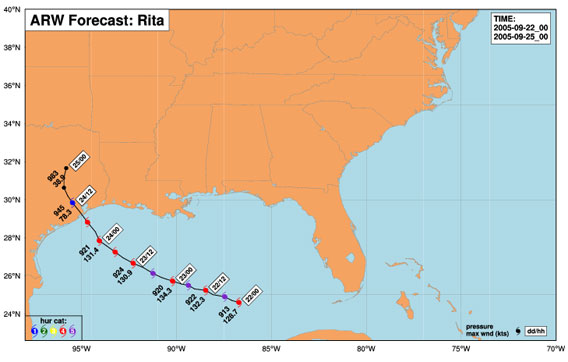 Three-day storm track [Snapshot at 9:17 AM PDT] Once or twice daily, NCAR’s Advanced Research WRF calculates a possible track over the next three days for hurricanes active near the southeastern United States. The high-resolution plot, created using observational data available at 00 Universal Time Code (7:00 p.m. Eastern Standard Time), uses a grid spacing of 4 kilometers, or 2.5 miles. |
BOULDER—An advanced research weather model run by the National Center for Atmospheric Research (NCAR) is following Hurricane Rita to give scientists a taste of how well forecast models of the future may predict hurricane track, intensity, and important rain and wind features. Tap into the model’s daily storm projection here.
With its high-resolution grid of data points just four kilometers (about 2.5 miles) apart, the model can project the location of fine-scale rainbands and eyewall structures 48 hours into the future.
It’s these storm features that determine where the greatest damage from both rain and wind might occur, says NCAR weather expert Chris Davis. Current operational forecast models use a coarser resolution and must approximate the cloud processes affecting intensity and precipitation.
Known as ARW, the computer model is NCAR’s research version of the Weather Research and Forecasting model (WRF), a joint effort by university and government scientists.
“ARW intensity predictions are very encouraging,” says Davis. “Five years ago, accurate intensity predictions weren’t even possible.”
|
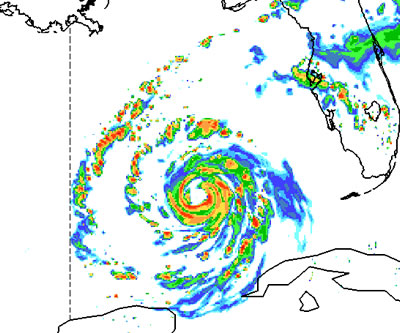
The model captured in detail the collapse of Hurricane Katrina’s eyewall at landfall and the shift of precipitation to the north side of the storm. Had the eyewall’s structure remained coherent, the winds would have been far more devastating. However, an eyewall always weakens at landfall, says Davis.
Teams supporting the Department of Energy and Department of Homeland Security are using real-time ARW data in their damage models. The researchers are testing how computer simulations of a particular hurricane’s most destructive features might improve damage model projections and lead to better warnings of floods, power outages, and road blockage. This year’s test cases have included hurricanes Katrina, Ophelia, and now Rita.
Meanwhile, a hurricane experiment in Florida is investigating the interactions between Hurricane Rita’s rainbands and its eyewall. NCAR’s Wen-Chau Lee is flying through the storm aboard a Naval Research Laboratory P-3 aircraft to gather radar data from inside the bands. The observations from the Hurricane Rainband and Intensity Change Experiment (RAINEX) will help scientists better understand the impact of the rainbands on the storm’s maximum winds.
NCAR is operated by the University Corporation for Atmospheric Research under the sponsorship of NSF and other agencies. Opinions, findings, conclusions, or recommendations expressed in this publication do not necessarily reflect the views of any of UCAR’s sponsors.
This is a press release from the National Center for Atmospheric Research (NCAR). The original copy can be found at www.ucar.edu/news/releases/2005/wrf.shtml
Related articles:
What is a Category 5 Hurricane? – 21-September-2005
Hurricane Rita just strengthened to a Category 5 hurricane. A Category 5 hurricane is the strongest and most severe class of hurricane. The scale, known as the Saffir-Simpson Hurricane Scale, classifies hurricanes by the intensity of their sustained winds, storm surge and flooding, developed in 1969 by civil engineer Herbert Saffir and National Hurricane Center director Bob Simpson.
US summer wetter, warmer than usual says NOAA – 21-September-2005
The June-August summer season was the tenth warmest on record for the contiguous U.S., while precipitation was above average. Global temperatures were second highest on record for the boreal summer, which runs from June 1 through August 31. Twelve named tropical systems formed in the Atlantic by the end of August, including Hurricane Katrina, which was among the strongest hurricanes ever to strike the U.S.
Tampa Bay could be hit by 25-foot storm surge in Category 4 hurricane – 16-September-2005
A Category 4 hurricane could cause a storm surge of as much as 25 feet in Tampa Bay, according to a University of Central Florida researcher who is looking at the risks Florida cities face from tidal surges and flooding.
Number of Category 4 and 5 hurricanes has nearly doubled over past 35 years – 16-September-2005
The number of Category 4 and 5 hurricanes worldwide has nearly doubled over the past 35 years, even though the total number of hurricanes has dropped since the 1990s, according to a study by researchers at the Georgia Institute of Technology and the National Center for Atmospheric Research (NCAR). The shift occurred as global sea surface temperatures have increased over the same period. The research appears in the September 16 issue of Science.
Hurricane could hit Los Angeles, San Diego – 8-September-2005
San Diego has been hit by hurricanes in the past and may be affected by such storms in the future according to data from the National Oceanic and Atmospheric Administration (NOAA). While a hurricane in San Diego would likely produce significantly less damage that Hurricane Katrina in New Orleans, it could still exact a high cost to Southern California especially if the region was caught off guard.
Environmental problems worsened Hurricane Katrina’s impact – 31-August-2005
The loss of coastal marshlands that buffer New Orleans from flooding and storm surges may have worsened the impact of Hurricane Katrina.
Hurricanes getting stronger due to global warming says study – 29-August-2005
Late last month an atmospheric scientist at Massachusetts Institute of Technology released a study in Nature that found hurricanes have grown significantly more powerful and destructive over the past three decades. Kerry Emanuel, the author of the study, warns that since hurricanes depend on warm water to form and build, global climate change might increase the effect of hurricanes still further in coming years.