A new image released by NASA reveals the impact of the worst drought on record on the world’s largest river.
The image, captured December 10, 2010, shows the Rio Negro, one of the Amazon’s largest tributaries, at the lowest level ever recorded. Measurements taken December 3, 2010 at the city of Manaus found the river level at a record-low 13.63 meters.
NASA released the following statement describing the image, which is compared with a second image taken on December 9, 2008.
-
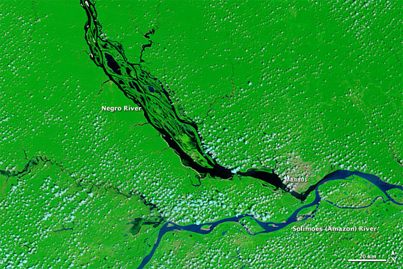
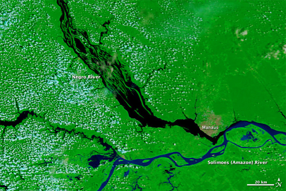
The images include both infrared and visible light in a combination that highlights the presence of water of the ground. Clear water is black, while sediment-laden water, such as the Amazon River, is dark blue. Clouds are pale blue and plant-covered land is green. The city of Manaus is light tan.
The Negro River is significantly smaller in 2010 [top] than in 2008 [bottom]. The most notable difference is in the braided channels northwest of Manaus. Many of the channels disappeared in 2010, and all are shrunken. The main body of the river near Manaus is narrower. Every body of water in the scene, including the Amazon River, also changed. Tan islands dot the Amazon where water had been in 2008.
2010
2008
NASA images courtesy the MODIS Rapid Response Team at NASA GSFC..
The 2010 drought, which brought river transport to a standstill and stranded remote communities, comes only five years after the “once-in-a-century” drought of 2005. The record river low comes only 16 months after river levels reached a record high of 29.77 meters in Manaus.
The fluctuations are consistent with climate models for the region, which project heavier rainfall in the wet season, especially in the western and northern parts of the Amazon, and less precipitation in the dry season, especially in the southern Amazon. This year’s drought helped spur a large increase in wildfires and a spike in forest degradation in recent months.
Related articles