 Mongabay, a leading resource for news and perspectives on environmental and conservation issues related to the tropics, has launched Tropical Conservation Science - a new, open access academic e-journal. It will cover a wide variety of scientific and social studies on tropical ecosystems, their biodiversity and the threats posed to them.


New software showing most efficient way to transport goods: rail, road, waterway?
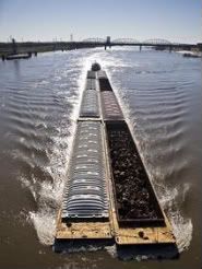 Researchers from the Fraunhofer Institute for Material Flow and Logistics (IML) in Dortmund are developing new comprehensive software that determines the cheapest, fastest or most environmentally compatible mode of transportation for a wide range of goods. Biomass as well as other agricultural products are being increasingly traded across countries and continents, but transport costs can be relatively high. The new software helps to lower costs by showing when it is best to make use of rail, road or waterway. It is the first highly integrated and detailed logistics model to do so, and it will be available online soon.
Most national and international freight is transported by road, because it is the least expensive option. But this is likely to change soon, due to road tolls and the rising cost of fuel. Even when it’s a question of making sure that the merchandise is delivered precisely on time, trucks are not always the most reliable solution. It can often take a long time to clear goods through the container terminals, and tailbacks on the motorways can cause additional delays.
So what is the optimum strategy for transporting goods over a particular route? Where could costs be saved by using inland waterways, and at what point would it be best to transship to a road or rail vehicle? What is the cheapest, fastest, or most environmentally compatible overall solution? All answers can be provided by the new software package.
The user enters the locations between which the goods are to be transported, as you would when using a route planner, says IML team leader Joachim Kochsiek. The system calculates different variants to find the optimum solution that fits the specified criterion: costs, time or, in a future version, least environmental burden. It even factors in the time and costs for transshipment.
Digital maps of road, rail and inland waterway networks can be purchased off the shelf, but the information they provide is not sufficiently detailed for the new software:
 energy :: sustainability :: biomass :: bioenergy :: biofuels :: commodities :: logistics :: trade :: efficiency ::
 There are different categories of train, and different pricing systems for different rail connections – you can’t simply apply a standard price per kilometer. Producers, traders and transportation companies need to know what rules to apply to the speed, width and height of trains, how many wagons are permitted on a particular section of railroad, and the maximum speed limit. Whereas this kind of information is included in road maps, it has to be compiled manually for the rail networks, Kochsiek explains.
For each mode of transportation, the system adapts its calculation of costs and fuel consumption to the degree of capacity utilization. For example, the lower the number of wagons pulled by a locomotive, the higher the costs.
A prototype version of the software for optimizing time and costs is already available. The researchers are now working on the algorithms for calculating the environmental burden. A later version with online access will enable modified shipping timetables, for instance, to be instantly included in the calculations.
References:
Fraunhofer-Gesellschaft: Rail, road or waterway? - September 8, 2008.
Fraunhofer Institute Materialfluss und Logistik.
posted by Biopact team at 6:54 PM
![]()
![]()


0 Comments:
Post a Comment
Links to this post:
Create a Link
<< Home