- Experts and activists say the construction of Indonesia’s new capital city upstream of Balikpapan Bay on the island of Borneo fails to mitigate against damage to the marine ecosystem.
- The stretch of coast between the bay and the mouth of the Mahakam River is packed with mangroves, which host a rich diversity of marine and terrestrial life, including proboscis monkeys and Irrawaddy dolphins.
- The government has said the construction of the new capital, Nusantara, will include retaining a large swath of mangrove forest, but zoning details show most of it won’t be protected against development.
- The $33 billion planned city will in 2024 take over as the Indonesian capital from Jakarta, and its full construction will be completed by 2045, according to the government’s plans.
JAKARTA/NORTH PENAJAM PASER, Indonesia — The Indonesian government’s strategy to minimize the marine impacts of building a new capital city on the island of Borneo is severely lacking, researchers and activists say.
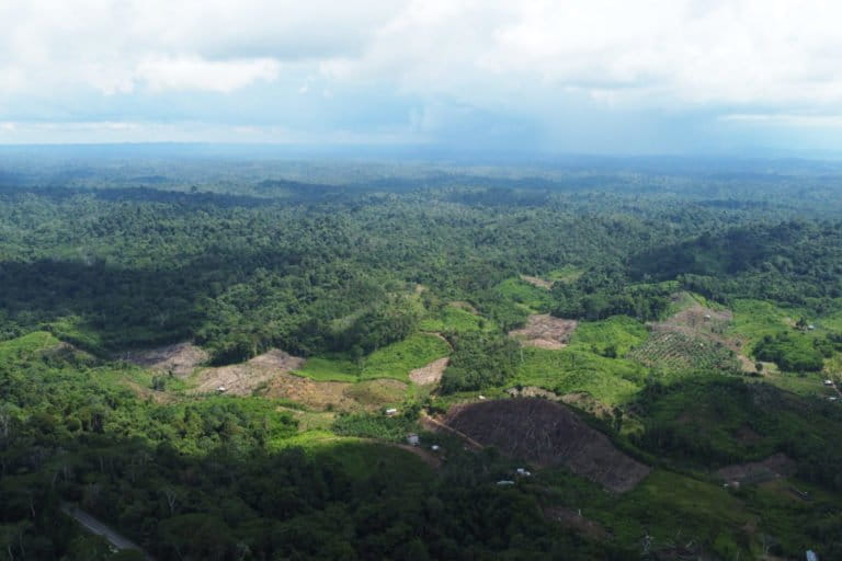
The city of Nusantara, where the government will move the nation’s capital in 2024 from Jakarta, is being constructed in the province of East Kalimantan, upstream of the port city of Balikpapan.
Balikpapan Bay is home to large expanses of mangroves that host a rich diversity of marine and terrestrial life. Coral reefs and seagrass meadows are believed to grow underwater, and traditional fishers have relied on the bay for their livelihoods since the 1970s.
But all this is under threat from the new city taking shape upriver, said Imam Syafi’i, a political researcher at the National Research and Innovation Agency (BRIN), a government-funded agency.
“Unfortunately, when parts of the bay’s upstream have been annexed for the new capital, no strategy has apparently been developed to conserve the wildlife living in the bay’s downstream,” he said in a webinar on Oct. 7.
Mapaselle, executive director of the community conservation group Pokja Pesisir, echoed the concern over the lack of any mitigation plan to protect the bay.
“The development plan of the new capital that’s located upstream of Balikpapan Bay has yet to include any mitigation measures of its impacts to the downstream area,” he said at the same online discussion. “All of this certainly will exacerbate the degradation of Balikpapan Bay.”

Balikpapan Bay sits less than 100 kilometers (60 miles) from where the Mahakam River, the third-longest in Borneo, empties out into the Makassar Strait. The bay’s mangroves host some 1,400 proboscis monkeys (Nasalis larvatus), a species endemic to Borneo. The Mahakam, meanwhile, is the core habitat of the critically endangered Irrawaddy dolphin (Orcaella brevirostris) in Borneo, with the mammals often spotted in Balikpapan Bay. But decades of urban and industrial development along the coast, and disastrous spills polluting the waters have degraded the bay’s ecosystem.
East Kalimantan is Indonesia’s coal-mining heartland, with an estimated 28% of the country’s reserves of the fossil fuel. More than half of the province’s total land area has been allocated for mining concessions. Balikpapan, the province’s biggest city, is home to oil and gas refineries and a busy seaport, while Kutai Kertanegara district, further inland and closer to the site of the new capital, is Indonesia’s biggest coal producer.
The sustainability of Balikpapan Bay’s ecosystem at large is also important for the welfare of fishing communities living in the area. Official estimates point to at least 12,000 fishing households in both Balikpapan city and neighboring North Penajam Paser district, part of which will be annexed for the new capital. However, the coastal zoning plan for East Kalimantan province for 2021-2041 designates a fishing zone that’s farther out to sea than traditional and small-scale fishers can reasonably reach.


The Indonesian government has promised that the construction of Nusantara, slated for completion in 2045 and estimated to cost $33 billion, would not clear protected forest and would promote the concept of a “forest city” and a “green-blue city,” with 75% of its area said to be forest.
The national development planning agency says the master plan for Nusantara makes no mention of clearing mangroves for the construction of the city’s infrastructure. The Ministry of Marine Affairs and Fisheries has also pledged to protect the mangroves in Nusantara while also promoting ecotourism.
“The certain thing is that the mangroves of Balikpapan Bay are in very good condition,” Satyawan Pudyatmoko, the deputy for planning and evaluation at the government’s Mangrove and Peatland Restoration Agency (BRGM), told Mongabay. “Great mangrove cover and high biodiversity.”
The new capital will encompass some 20,000 hectares (nearly 50,000 acres) of mangroves. Crucially, however, three-quarters of this will be open for development, according to an analysis by the Auriga Nusantara Foundation, a conservation nonprofit.

Indonesia also has a wider national target of rehabilitating 630,000 hectares (1.56 million acres) of mangroves by 2024 as part of its mitigation plan against climate change. If any of the mangroves in East Kalimantan were to be cleared for the construction of Nusantara, it would be “ironic,” said I Nyoman Suryadiputra, a senior adviser to Wetlands International Indonesia. He added it had taken his own organization 24 years to restore just 4,000 hectares (9,900 acres) of mangroves.
Mapaselle of Pokja Pesisir also cautioned the government against “copying and pasting” the example of Jakarta Bay’s development onto Balikpapan Bay. The government’s plan to relocate the capital was attributed in large part to Jakarta experiencing a higher rate of land subsidence than any other major city in the world, leaving 40% of the city lying below sea level.
To save the nation’s capital from being inundated by seawater, both the national and city governments launched the so-called Giant Sea Wall project in 2014 along the northern coast of Jakarta, including its bay. Many experts and activists have said the development since then has caused environmental damage to the bay and destroyed the livelihoods of local fishers.
“Our hope is to have our seas stay blue and our coasts green,” Mapaselle said.

Basten Gokkon is a senior staff writer for Indonesia at Mongabay. Find him on Twitter @bgokkon.
FEEDBACK: Use this form to send a message to the author of this post. If you want to post a public comment, you can do that at the bottom of the page.