
- In Belize, the coral atoll Glover’s Reef is an important conservation site, home to hundreds of species of marine life — and traditionally been a popular spot for local fishermen.
- The marine protected area has a multi-use zone that allows fishermen to work in the area while protecting biodiversity.
- Nevertheless, some shark populations have declined in recent years despite careful management by the Belize fisheries department and NGOs.
- Adriel Castañeda, an officer with the Belize Fisheries Department and coordinator for the ecosystem-based management unit, spoke with Mongabay about the challenges of preserving the reef while upholding the customs of local communities.
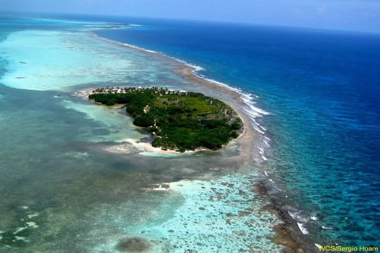
Glover’s Reef, part of the Belize Barrier Reef, is one of only four atolls in the Western Hemisphere. The rare, ring-shaped island of coral surrounds a lagoon 45 kilometers (28 miles) off the Belize coast, and takes up 35,000 hectares (86,000 acres).
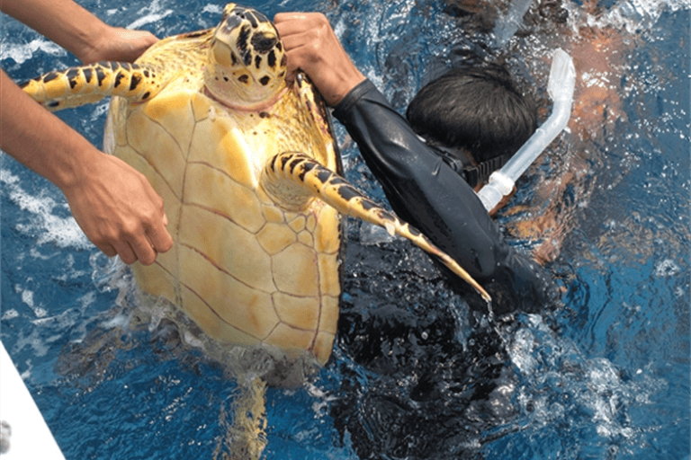
The reef is home to dozens of species of sharks, including the endangered Cuban night shark (Carcharhinus signatus) and Caribbean reef shark (Carcharhinus perezi), as well as numerous stingrays and other fish. The abundance of wildlife has traditionally attracted fishermen to the spot, leading officials to find a way to protect the ecosystem while upholding the customs of local communities.
In 1993, Glover’s Reef was named a national marine protected area. A few years later, it was listed as a UNESCO World Heritage Site. The reserve is broken down into different conservation zones, which allow residents to fish near some parts of the reef.
Earlier this year, Mongabay reported that some sharks, most notably the Caribbean reef shark, had been on the decline over the past decade, possibly due to legal fishing on the edges of the protected area. There has also been some illegal activity, often at night when regulations are harder to enforce.
“Most of it is encroachment into the conservation zone,” Kenneth Gale, operations manager for the Wildlife Conservation Society’s (WCS) Glover’s Reef Research Station, told Mongabay. “Fishing out of season of products or undersized products. We also see people fishing without fisher folk licenses. So there is actually a wide array of infractions that have been seen there.”
Belize is one of more than 100 countries that has signed on to the “30 by 30” initiative, a global plan to conserve 30% of Earth’s land and oceans by 2030. The goal is to preserve around a third of the planet’s ecosystems to protect biodiversity and stave off climate change.
However, there has been some criticism from Indigenous groups in numerous countries about the 30×30 approach being too “simplistic.” It could increase the risk of human rights abuses against local communities if governments look to secure land for conservation purposes without consulting them first, or granting them land tenure rights or access to fishing areas to practice their livelihoods.
Glover’s Reef, given its recent struggles with fishing on the limits of the protected area, raises questions about how to balance conservation efforts with the needs of local communities. A small fraction of fishermen have advocated for the expansion of the conservation zone and to increase the size of the reserve, according to WCS.
Adriel Castañeda, a fisheries officer at the Belize Fisheries Department and coordinator for the ecosystem-based management unit, helps oversee all of Belize’s nine protected marine reserves. He has worked with WCS and local fishermen to find the best approaches to striking the right balance.
In this interview with Mongabay’s Maxwell Radwin, Castañeda talks about the key to preserving Glover’s Reef, the relationship with traditional fishers, and why he’s experimenting with using drones to carry out patrols.
Mongabay: Glover’s Reef has been around for 30 years, and largely managed to preserve the atoll ecosystem while allowing fishermen to continue their livelihoods. What do you attribute that success to?
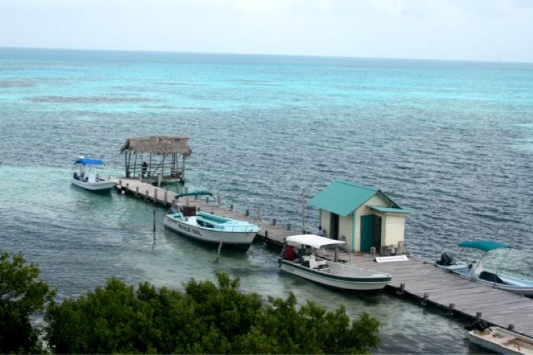
Adriel Castañeda: Well, one of the things that has been very beneficial is the partnership that we’ve had with the Wildlife Conservation Society. They’ve been there for many years. Actually, they own an island known as Middle Caye, and that is where we have our station as well for our patrol staff and manager. And they’ve assisted us in doing a lot of the monitoring and have supported the management of the area in terms of assisting with fuel for patrols, assisting with personnel for monitoring, being in charge of the funding…monitoring, building capacity in our staff. Those things have been very helpful to assist in management. That has been very key. Plus, they have also hosted several researchers that have been coming to Belize to assess the atoll itself, from the fishery, scallops, lobster, for example, the corals to all kind of stuff. That has been essential for building the knowledge around the atoll.
Mongabay: Fishing is permitted in that area, but it’s only permitted for certain local fishermen at certain times of the year (lobster season is from July 1 to March 31 while conch season lasts from October 1 to June 30) and in certain zones of the reserve. How does that system work, and do you think it’s effective?
Adriel Castañeda: Fishing is permitted in the atoll. All of our marine reserves are composed of small multi-use reserves. They have a conservation zone, a preservation zone, and the general use zone, which is where fishing occurs. The general use zone mostly is about 80% to 85% of the atoll itself. And the remaining 15% to 20% is the divide between the preservation and the conservation zones … In the case of Glover’s, there’s a wilderness zone right in front of Middle Caye, where WCS is, just as a sanctuary for some baitfish that we have there that are unique within the atoll.
Mongabay: How does the fisheries department and WCS juggle conserving the area and allowing fishing? Can that be a difficult two-pronged approach at times?
Adriel Castañeda: Well, it’s difficult. I won’t say it’s not. What helps a lot is the distance it has from the mainland. By itself, the distance reduces the amount of people that access the area. The atoll is fairly large, but it’s workable with our staff, so in addition to that, we have a close partnership with the Coast Guard, which is also hosted by WCS within the Middle Caye field station that assists us in doing joint patrols within the atoll.
Mongabay: This is a slightly different situation than many other multi-use areas in the world because these waters are not ancestral waters belonging to a nearby community. The traditional fishermen — those who have demonstrated a long-term commitment to the area and come from historical fishing communities — are traveling from different faraway areas to fish.
Adriel Castañeda: In terms of the fishermen, the [conservation agreement] gives only traditional fishermen access to the area … But in 2010, the department embarked on a program called Manage Access at two sites. Basically, we were trying to implement a rights-based approach to fishery management, trying to incorporate the idea of only traditional fishermen having access to the area for fishing. Prior to 2010, five years before, anybody who was there within that list would have gotten access. And from there, we set up a number of criteria for them to maintain their access. For example, they would have to have used the area at least three times per year and they would have had to submit catch data and that kind of stuff.
But in general, fishermen come from the northern part of the country. These are sailboat fishermen, meaning that they travel as a group, between 10 to 14 of them on a sailing sloop from Belize City, moving south to Glover’s Reef. But they reside in a certain area that is far north, bordering Mexico. And it’s a bit complex because they would have to take the bus from Belize City where they have their vessels, and from there they move on to their fishing site at Glover’s Reef.
Mongabay: If only local or traditional fishermen are allowed to use the area and no one new can use it, eventually there won’t be fishermen working there because you can’t introduce new people. Or is there a system for allowing new entrants?
Adriel Castañeda: We do allow new entrants. We formed what we call a managed access committee, which was made of official representatives, the management, WCS and us. And essentially we would do some sort of vetting to allow for new entrants. For example, a criteria would be if the fisherman is a relative of somebody that has been traditionally fishing there for some time, a son, maybe, or son-in-law or a very close relative. It could be someone that has been hired as a cook for some time within the sailing sloops. But essentially, we try to limit it mostly to people that have some vested interests … And then they would go through a probation period. So once they comply with the daily requirements, three visits to the area, catch submissions and so on, and they’re not committing an infraction, then we would be able to give them that access.
Mongabay: Are the people with access to the area happy with the access they have? The general-use zones of the reef make up a pretty small percentage of the whole. Are they able to get enough food and/or make enough money within the limits of the current regulations? While there is no cap on the amount of lobster that can be caught, for example, other species have special licenses that might be limiting for fishermen.
Adriel Castañeda: I think one of the things that benefited them a lot was that the program itself favored fishers that would stay within the atoll or fish within the atoll for the duration of the entire year or season. Because one of the main problems that we have had in the past was that for every opening of the main fisheries, there’s a rush of fishermen that would go there and compete with them for the first two trips, the first month per se, of the season. And the competition didn’t allow them to have as much … within the atoll. So what the program did was to eliminate those people that are just going there once or twice per year. So the fishermen that are now traditional and have the manage access to the area would be able to enjoy the privilege of having a bigger share of the pie, if you want to put it that way.
Mongabay: You mentioned working with WCS doing patrols and monitoring. Do you feel that the government has enough resources to do that work or does it need outside help? A lack of funding and resources has been an issue, leading to some problems like nighttime illegal fishing, for example.
Adriel Castañeda: Well, funding has been an issue for all of our protected areas. We’ve been looking at mechanisms for how to improve that. We’ve tried to pilot, for example, the use of drones so as to not have to spend as much fuel. We just send a drone to do our survey first and then we would be able to plan better our patrols, be more efficient. We’ve also used, again, through collaboration with WCS, the SMART system, which is a tool, using a cellphone or a GPS to log the information of all your patrols, from how much fuel you’re using to who you’re encountering while you’re doing patrols. And that gives you a visual for every time you do a patrol, you would see where it is, where the enforcement is focusing, where there are gaps and that kind of stuff … In addition to that, we are also looking at enhancing our co-management agreement because we feel that co-management is a very good option, a very viable option for assisted management, which has proven to be very, very effective for past areas that we’ve had co-managed.
Mongabay: When you say co-management, you’re talking about managing with groups like WCS or managing with local communities?
Adriel Castañeda: It could be either … It could be an NGO, it could be a CBO, a community-based organization, once it’s an established entity that can prove they can actually do the day-to-day management of the site.
Mongabay: That’s something you’re looking into, hoping to expand?
Adriel Castañeda: Yes. Well, we’re open to the opportunity, for any interest in that…We’ve partnered with Turneffe Atoll Sustainability Association, which is an NGO, a local NGO. And they’ve been able to take management to the next level with the amount of investment infrastructure and personnel, the amount of funding that they’re doing, the mixed financing being done with a business approach. So it just amplifies the opportunities that can be obtained for the protected area in comparison to government.
Mongabay: Do you feel that the model at Glover’s Reef is one that other parts of the Caribbean, other parts of Belize or the world should be replicating? Is it a successful, viable way of conserving marine habitats while also providing for local communities?
Adriel Castañeda: I think there are many aspects of it. Like I said, the partnership especially is very, very good. Also, we have a strong advisory committee. Of course, WCS has been one of the main funders for the meetings, and that provides a good level of guidance and supervision of the day-to-day work happening at the reserves and for any improvements or any recommendations. That is key.
Banner image: Caye Caulker in Belize. Photo courtesy Wikimedia.
FEEDBACK: Use this form to send a message to the author of this post. If you want to post a public comment, you can do that at the bottom of the page.