
- A series of roads in the Colombian Amazon are cutting through national parks and an Indigenous reserve, satellite imagery shows.
- Residents of the reserve and environmental experts say the authorities have done little to stop the expansion of the road network, which has been accompanied by extensive deforestation.
- Experts and anonymous sources say well-funded operators are behind this pattern of deforestation and the land grabbing that follows.
- Residents of the Yaguará II Indigenous Reserve, already facing violence from ex-guerrillas who once controlled this region, say they’re worried about the roads bringing in more settlers occupying their territory.
This report is part of a collaboration between Mongabay Latam and Rutas del Conflicto.
The departments of Caquetá and Guaviare, in southern Colombia, are covered in dense forest where for years entry was forbidden to most people. Groups engaged in the decades-long war against the government prohibited access to these areas, and only a few researchers were able to enter with their permission. With the signing of the peace agreement in 2016, the guerrilla group Revolutionary Armed Forces of Colombia (FARC), disbanded and control of much of its former territory passed into the hands of its dissidents.
Also since the signing of the peace deal, roads have spread throughout the region, according to satellite data. The Foundation for Conservation and Sustainable Development (FCDS), a Colombian NGO, has raised concerns and denounced the illegal extension of a particular road between Puerto Cachicamo and La Tunía, in the department of Caquetá. In total, the road stretches 66 kilometers (41 miles) south from Marginal de la Selva, intersecting Serranía de Chiribiquete National Natural Park and the Yaguará II Indigenous Reserve, until it reaches the Tunía River.
Sources say two more roads have been opened without state approval: a 58-km (36-mi) stretch connecting La Tunía with Camuya, most of it in the protected area of Serranía de Chiribiquete, and a 38-km (24-mi) road between La Playa and Río Yarí. According to local sources, the plan is for the three roads to join up and form a highway connecting the Sabanas del Yarí and Andean regions.

The Marginal de la Selva is a road that cuts through the northern Colombian Amazon between Puerto Cachicamo and La Tunía. A few kilometers to the west is the so-called cattle trail, another illegal road that’s been a center of deforestation activities and that intersects Sierra de La Macarena National Park, connecting the municipalities of Vista Hermosa and La Macarena in the department of Meta.
The development of this road is taking place in an area that functions as an important ecological corridor, which begins in the páramos (moorlands) of the Andes, goes through the high Andean forest, and connects with the Orinoco River Basin and extends into the Amazon.
Inhabitants of the Yaguará II Indigenous Reserve, which is intersected by these illegal roads, say their complaints have been ignored and that although the state is aware of what’s happening, it hasn’t committed to tackling this problem. They say that campesinos, smallholder farmers, are likely not the ones responsible for the deforestation, as they don’t have access to the heavy machinery used to expand and open the roadways.

Highways vs. forest
By 2019, more than 300 km (190 mi) of highways had been recorded in Sierra de la Macarena National Natural Park, according to a 2020 report by the FCDS. While Serranía de Chiribiquete is comparatively unscathed, a state official who requested anonymity told Mongabay and Rutas del Conflicto that road construction and associated deforestation is increasing in that park too.
Local officials, environmental experts and area residents told Mongabay and Rutas del Conflicto that there are economic interests tied up in connecting Sierra de la Macarena National Natural Park with the Llanos del Yarí region where the Yaguará II Indigenous Reserve is located. They warned that connecting these roads would lead to land grabbing due to the arrival of settlers from other parts of the country, as well as the expansion of agriculture and cattle ranching into forested areas.
“There are more roads near La Macarena, in the region of Montebello, on the borders of Guaviare and Meta. This has increased deforestation in this part of the reserve,” said a member of an Indigenous community who wished to remain anonymous.
Gloria Inés González, a researcher at the FCDS, said it’s not yet possible to ascertain whether there’s interest in connecting these roads.
“What we can see from monitoring is that there are indications of new mobility corridors and new access roads inside the reserve,” she said.
The government has blamed FARC dissidents for deforestation in this part of the country.
“The dissidents supposedly want to protect the forest, yet they support illicit crops and for this they have to cut down a lot of trees. They say one thing and do another,” said one source who wished to remain anonymous for safety reasons. Neither the national parks agency, known by its Spanish acronym, SINAP, nor the Corporation for Sustainable Development of the North-East Amazon (CDA) responded to requests for comment.
The Ministry of the Environment presented the deforestation figures for 2020 and confirmed that the construction of the road between Puerto Cachicamo and La Tunía was affecting forests in this area.
“We are looking at this together with the National Land Agency [ANT] and the Ministry of the Interior. Our natural resources are being destroyed and we will not allow it,” said Carlos Correa, the environment minister. He added that around the highway, plots of land of between 50 and 100 hectares (124-247 acres) are being illegally occupied.

While it’s unclear who exactly is responsible for illegal road-building in the region, one local source who requested anonymity said those deforesting vast tracts of land had a lot of money “because it’s neither cheap nor something a small-scale farmer can do on their own.”
Sources say the illegal roads within and between Sierra de la Macarena and Serranía de Chiribiquete national parks and the Yaguará II reserve are expanding the agricultural frontier, as well as connecting the north of the Amazon to the Altillanura region, an area where the Colombian government has promoted extensive agro-industrial projects such as the development of oil palm, corn and rice plantations.
A source on the ground, who asked to remain anonymous, told Mongabay and Rutas del Conflicto that the government is aware of the road between Cachicamo and La Tunía and the problems it’s causing, but that authorities have yet to take any action.
“We wanted to complain about the road and speak to a prosecutor but were told that a lot of paperwork would be involved and not to bother,” the source said.
In 2018, the governor of Guaviare at the time, Nebio Echeverry, requested the construction and expansion of a road connecting the municipalities of Calamar and Miraflores, in the department of Guaviare, to the protected Nukak National Natural Reserve. In 2019, the Ministry of the Environment fined Echeverry more than 1 billion pesos (around $265,000) for his actions.
“It should be legalized,” Echeverry said, according to statements compiled by Rutas del Conflicto. “The area has already been occupied. It’s already happened. The damage has already been done. The forest has already been cut down. There’s nothing we can do. It should be legalized.”
An environmental expert said people are flocking to Guaviare to stake their claims to land.
“Farms here are very cheap because they don’t have title deeds, so settlers have been coming and enclosing land, growing crops and raising cattle,” said the expert, who asked to remain anonymous. “Now people are coming from other places, from [the departments of] Caquetá and Arauca, to buy land, to open more roads, hoping that in the future laws protecting the land are repealed so they can get titles to it.”
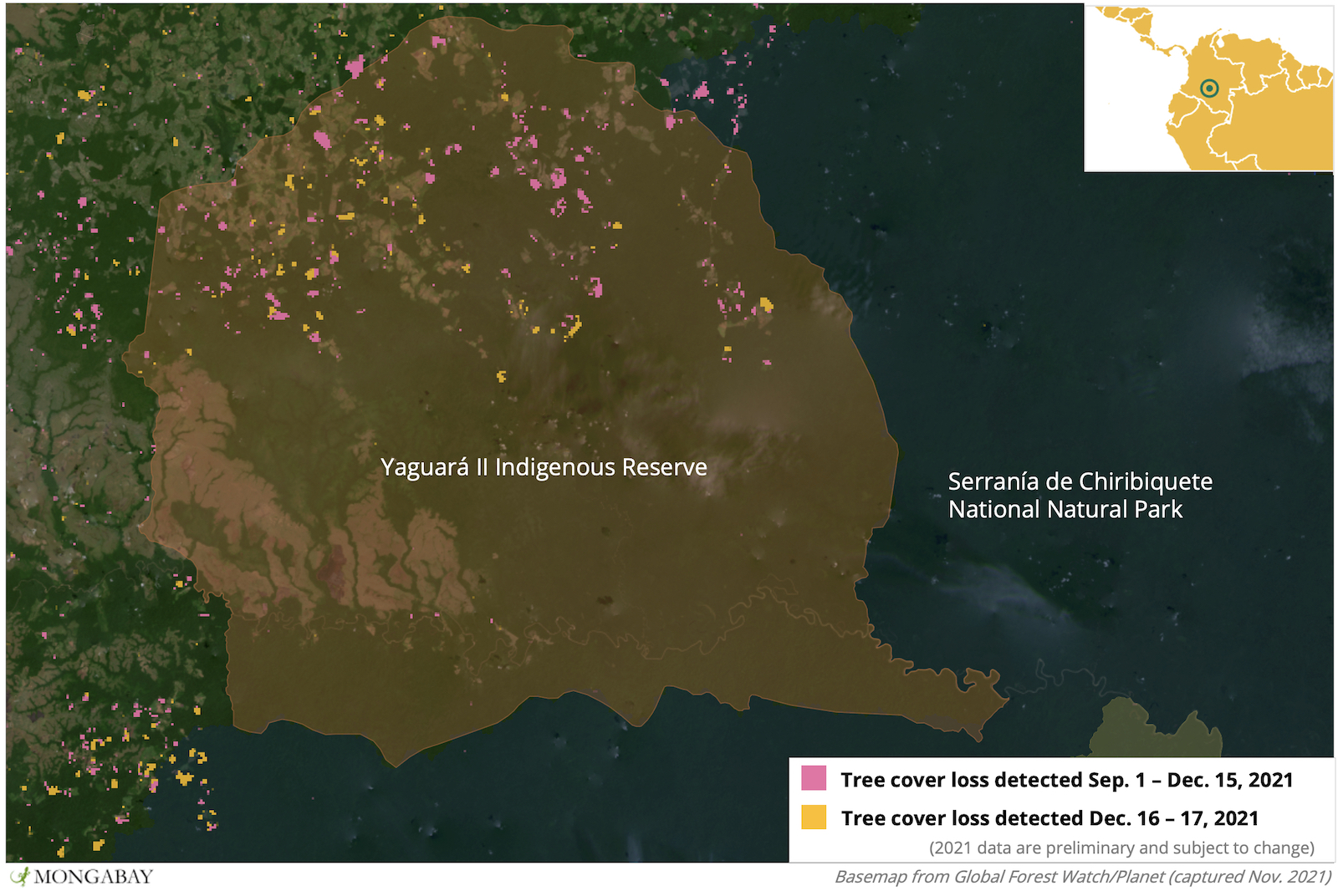
Between September 2020 and February 2021, more than 1,000 hectares (2,500 acres) was deforested in Serranía de Chiribiquete National Natural Park, primarily in the municipality of San Vicente del Caguán, and satellite data from the University of Maryland shows clearing has continued into December 2021. Forest also continues to be felled inside Indigenous reserves. According to the FCDS, 2,292 hectares (5,664 acres) of forest were lost in the Yaguará II reserve between 2019 and 2020.

Yamile Salinas Abdala, lawyer and researcher for the Institute for Development and Peace Studies (Indepaz), has conducted several studies on land use in Colombia. He said deforestation and occupation of protected areas is part of a long-term process that allows large companies to accumulate land in collusion with government officials.
According to Salinas, this process has resulted in the displacement of Indigenous and campesino communities, as well as the destruction of ecosystems. He said large companies, aided by policy loopholes and partnerships with government officials, may legalize ownership of these lands, adding that this has been documented within many industries in Colombia, including agriculture, mining, energy production and infrastructure development.
An Indigenous reserve besieged
Indigenous residents of Yaguará II said the construction of the illegal highway between Puerto Cachicamo and La Tunía is bringing deforestation and outsiders into their territory.
“The road is the most advanced and the most extensive; there are practically only a couple of kilometers left before it reaches the Tunía River,” said a resident who asked to remain anonymous. “We are worried because of the arrival of settlers and because we use the river for fishing.”
According to the FCDS, 506 km (314 mi) of roadways were constructed in Indigenous reserves in the departments of Guaviare and Caquetá in 2019 alone. Satellite data from the University of Maryland visualized on Global Forest Watch show deforestation surged further in both departments in 2020 and 2021, pockmarking Yaguará II and bleeding into Serranía de Chiribiquete.
The Yaguará II reserve is inhabited by members of the Pijao, Tucano and Piratacuyo Indigenous groups. The Pijao came to the area in 1964 after fleeing violence in the municipality of Chaparral.
The reserve was legally established in 1994, but conflict with FARC guerrillas forced many residents to move to the town of San Vicente del Caguán in the early 2000s. The displaced residents of Yaguará II lodged an appeal to recover their territory and the case was accepted by the Land Restitution Unit (URT). While the URT was able to enact protective measures in 2017 in an effort to limit deforestation and prevent violence against Indigenous residents, the case has yet to reach a judge.

However, residents say the URT’s protective measures have not been effective and that they still face violence if they return to Yaguará II. Despite this, 24 families comprising more than 70 people have risked their lives and returned to their territory. Advocates say the families who have returned are working on projects to strengthen their presence and to prevent deforestation alongside various organizations, such as the CDA (the environmental authority in this region of the Amazon), the FCDS and the Frankfurt Zoological Society (FZS).
“We are working with the Frankfurt Zoological Society to form a surveillance body called the Indigenous Guard,” said one local source who requested anonymity. “A group has been trained in tasks that should be carried out to protect the boundaries.”
Meanwhile, the FCDS is helping residents develop a strategic and economic plan.
“When the peace agreement was signed, the idea was to promote nature tourism, but this has changed to a community forestry plan that includes sustainable use of the forest,” said Gloria Inés González of the FCDS.
Banner image courtesy of the Rutas del Conflicto Archive.
This story was reported by Mongabay’s Latam team and first published here on our Latam site on July 12, 2021.
Editor’s note: This story was powered by Places to Watch, a Global Forest Watch (GFW) initiative designed to quickly identify concerning forest loss around the world and catalyze further investigation of these areas. Places to Watch draws on a combination of near-real-time satellite data, automated algorithms and field intelligence to identify new areas on a monthly basis. In partnership with Mongabay, GFW is supporting data-driven journalism by providing data and maps generated by Places to Watch. Mongabay maintains complete editorial independence over the stories reported using this data.
Feedback: Use this form to send a message to the editor of this post. If you want to post a public comment, you can do that at the bottom of the page.