
- Tim Killeen provides an update on the state of the Amazon in his new book “A Perfect Storm in the Amazon Wilderness – Success and Failure in the Fight to save an Ecosystem of Critical Importance to the Planet.”
- The book provides an overview of the topics most relevant to the conservation of the Amazon’s biodiversity, ecosystem services and Indigenous cultures, as well as a description of the conventional and sustainable development models vying for space within the regional economy.
- Mongabay will publish excerpts from the Killeen’s book, which will be released by The White Horse Press in serial format over the course of the next year. In this second installment, we provide a section from Chapter Two: “Global Competition Drives Bulk Transport Systems”.
- This post is an except from a book. The views expressed are those of the author, not necessarily Mongabay.
Editor’s note: Tim Killeen provides an update on the state of the Amazon in his new book “A Perfect Storm in the Amazon Wilderness – Success and Failure in the Fight to save an Ecosystem of Critical Importance to the Planet.”
The book provides an overview of the topics most relevant to the conservation of the Amazon’s biodiversity, ecosystem services and Indigenous cultures, as well as a description of the conventional and sustainable development models vying for space within the regional economy.
The narrative explains the social and economic realities that constrain the decisions of stakeholder groups and economic actors and motivates them to act as they do. It also identifies the policies that have created a foundation for change in the region, as well as those that are not delivering the benefits their advocates had hoped to generate.
Mongabay will publish excerpts from the Killeen’s book, which will be released by The White Horse Press in serial format over the course of the next year (Killeen is also working to adapt the book into Spanish and Portuguese). In this second installment, we provide a section from Chapter Two: The State of The Amazon.You can read the first at The political economy of the Pan-Amazon.

Global Competition Drives Bulk Transport Systems
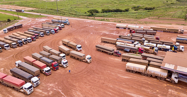
The modification of the rivers in Brazil has been driven by energy development, but investment in dams has the potential of creating an economically attractive option for shipping Brazil’s farm exports to overseas markets. In the 2019/2020 crop year, Mato Grosso produced 35 million tonnes of soybeans, an increase of about forty per cent over 2015/2016. In 2017, nine per cent was consumed within Mato Grosso, six per cent was shipped to other Brazilian states and the remainder was exported directly to overseas markets, mainly China (66 per cent) and Europe (twelve per cent). Soybeans are transported to export terminals by a combination of truck, rail and barge. Producers in Mato Grosso are overly reliant on truck transportation because they operate on frontier landscapes without access to modern rail systems. Until recently, most exported their production via ports in São Paulo and Paraná due to logistical constraints that limited transit to ports on the Amazon River. The need for bulk transport systems has increased over the last decade, not only due to an increase in soy production, but because of a parallel growth in exports of maize, which is increasingly grown in rotation with soybeans (see Chapter 3).
Truck transportation is inherently inefficient, and the cost of moving grain by truck 2,000 kilometers to the Port of Santos in São Paulo has fluctuated between $US 80 and 120 per ton over the last decade. Farmers in Mato Grosso compete in global markets with producers from other counties with significantly lower transportation costs. In Argentina, the distance is typically less than 400 kilometers, and its legacy railroads provide producers with an efficient transport option; for example, the cost between Cordoba and the port of Rosario is only $US 30 per ton. The distance between producing landscapes and export terminals in the United States is longer, but the US has highly efficient bulk transportation systems, including an extensive rail network and the Mississippi waterway, where the shipping costs from Iowa to New Orleans (2,300 kilometers) is only $US 20 per ton.
Opportunities to lower transportation costs are the most obvious intervention point for improving the competitiveness of Brazil’s soybean exports. Lower transportation costs will enhance profitability for Mato Grosso’s farmers because commodity traders pay producers the international price for their harvest minus the cost of transport and logistics.[1] High transportation costs are essentially a rent that benefits truckers and impedes farmers’ ability to invest in their productive capacity, which explains why agribusiness has made investments in bulk transport systems a national priority.
As the cultivation of soy exploded across the Southern Amazon, the global commodity trader and logistical companies[2] began to invest in transportation systems via the Amazon River. By 2013, approximately thirty per cent of the soy cultivated in central Mato Grosso was exported via Amazonian ports, and by 2017 this proportion had increased to seventy per cent. The shift in transportation patterns has not been due to a reduction in grain shipped via southern ports – that amount has remained relatively constant – but because of increased production within the Amazon.


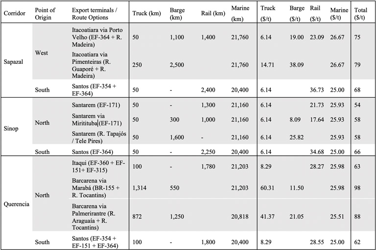
Amazonian options are organized into three logistical corridors with different multimodal combinations of truck, barge and rail (Figure 2.22; Table 2.1). Simultaneously, the cost competitiveness of the southern option has been improved by the extension of a rail line into southern Mato Grosso that has reduced the truck transport component by 1,400 kilometers. Producers across central Mato Grosso now have four options for commercializing their production:
- West: Farmers truck their grain via BR-364 to Port Velho, where it is loaded on barges for trans-shipment to Itacoatiara (Amazonas), a port located 75 kilometers east of Manaus, just across the channel from the mouth of Rio Madeira.
- Central: Farmers truck their grain north via BR-163 to Santarem or Miritituba (Pará) on the Rio Tapajós for loading onto barges for trans-shipment to ocean-going ports on the Amazon River.
- East: Farmers can use truck transport (BR-158/155) to Marabá (Pará) or the recently completed rail line, Ferrovia Norte – Sur (EF-151), both of which connect with the pre-existing rail line, Estrado Ferro Carajás (EF-315), between Marabá and São Luis do Maranhão.
- South: Farmers across the region have the option of trucking their grain to a large logistical complex at Rondonópolis (Mato Grosso) where they can transfer their grain to the Ferrovia Norte (EF-364)[3] for trans-shipment to the grain terminals at Santos (São Paulo).

The expansion of Amazonian ports has improved the profitability of Mato Grosso farmers, but those benefits remain limited by a combination of factors, including a lack of silos and port facilities, poorly maintained roads and, in the case of Porto Velho, an additional 1,000 kilometers of barge transport. The long-awaited completion of BR-163 in 2019 eased some of these constraints and motivated commodity traders and logistic companies to invest in silos and barge-loading facilities at Miritituba,[4] fleets of high-capacity barges and the expansion of the grain terminals at Barcarena and Santana.[5]


Between 2013 and 2017, exports via the three northern corridors represented an annual saving of about $US 100 million when compared to the previous option of trucking production to Santos or Paranaguá (Paraná). The transition from truck to rail for the 1,400 kilometers between Rondonópolis and Santos, however, represented an even greater savings of approximately $US 200 million.[6] The transition to rail highlights the potential savings that will accrue as the logistical systems continue a transition away from truck transport and toward rail and barge systems. The estimated savings from future investments in bulk transport systems, perhaps as large as $US 1 billion annually, will lower the logistical cost of producers from central Mato Gross to levels that are cost competitive with their global competitors (Table 2.2). Not surprisingly, farmers are strong advocates for the construction of railways and the modification of rivers so they can function as commercial waterways.
The Institute of Economic Analysis (IPEA) of Brazil assessed the comparative costs and benefits of waterways when compared to railroads. Based on a standard unit of 1,000 kilometers, a projected lifespan of 25 years, and an average transport of 10 million tonnes of goods per year, fluvial transportation was estimated to be about 35 per cent less expensive when compared to railways (Figure 2.23). This estimate excluded capital investment in dams, however, which are essential components on all Brazilian waterways; for this reason, the construction of hydropower assets constitutes a massive subsidy. The IPEA included neither the cost of the environmental damage that this type of infrastructure would inflict on the Amazon ecosystem, including modifications to the hydrology of its river systems, nor the increased deforestation that might be stimulated by the expansion of agriculture.
Waterway options
The main stem of the Amazon River has provided access to ocean-going cargo ships for centuries, including modern container ships that service the manufacturing sector in Manaus and ore-carriers that haul bauxite from near Oriximiná (Pará) and iron ore and manganese from Santana (Amapá). The first modern grain terminal, built at Itacoatiara in 1998 across from the mouth of the Madeira River (Amazonas), was followed in 2003 by one at Santarem (Pará) at the mouth of the Tapajós, in 2014 at Barcarena near Belem (Pará) at the mouth of the Tocantins, and in 2016 at Santana (Amapá) on the north side of the Amazon delta. These terminals are currently receiving grain from barge loading facilities located at the top of the three major transportation corridors, each of which has developed or hopes to expand an industrial waterway, known as a hidrovía.[7]

Above Manaus, on the section of the river known as the Solimões, river traffic declines by several orders of magnitude because there are no industrial mines or agricultural landscapes producing commodities at scales required to support a bulk transport system. A few ocean-going cargo ships hauling timber are known to operate sporadically from Iquitos (Peru) or deliver heavy machinery required by the oil and gas industry at Coari (Amazonas) and Iquitos. River traffic consists largely of riverboats providing fuel and consumer goods to riparian communities (HML #3), cruise liners catering to tourists on the Rio Negro and timber for the manufacturing sector in Manaus or for export to overseas markets. There is an uptick in activity on the tri-border area around Tabatinga (Brazil), Leticia (Colombia) and Santa Rosa de Yavarí (Peru).
The aspiration of creating an industrial waterway between Brazil and the Andean republics is a major component of the IIRSA investment portfolio (Figure 2.1), which includes eighteen projects organized in four groups with a total budget of $US 530 million.[8] This basket of proposed and completed projects represents a laudable effort to provide sustainable transportation options that minimize the need for roads. Unfortunately, most river port investments on the Andean piedmont are akin to the Field of Dreams approach to infrastructure planning: If you build it, they will come.[9] There is no commercially relevant bulk cargo in either direction between Brazil and the Andean nations, while the manufactured goods produced in Manaus are not likely to be competitive with similar products from East Asia.


That does not mean, however, that these are not ‘good’ investments. They provide essential services to many isolated communities of the region that are being denied road access in the name of forest conservation. As such, their development should not be viewed as an investment that will pay for itself but as a subsidy to support nature-based livelihoods. Ironically, the one example where a waterway might be able to support a self-sufficient commercial transportation system is opposed by environmental and social advocates: the Hidrovía Amazónica between Iquitos, Yurimaguas, Pucallpa and Saramariza in Peru. Resistance is based, in part, on the impacts caused by dredging operations on problematic sections of the river but also from current operators and inhabitants, including indigenous communities, who fear they will be exploited by the concessionaire that has been awarded the contract to upgrade and operate the waterway.[10]
Río Madeira
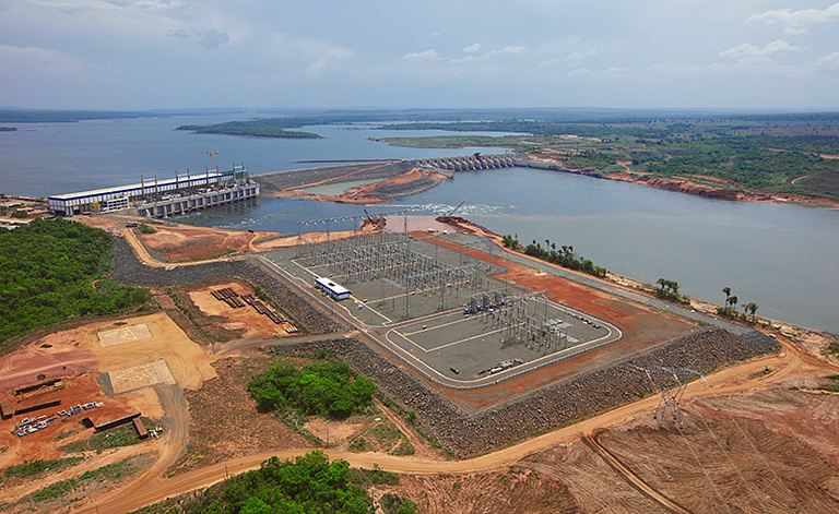
The largest tributary of the Amazon[11] has functioned as fluvial corridor for millennia and was a major commercial artery during the rubber booms of the nineteenth and twentieth centuries. Since 1998, it has experienced a commercial revival due to the transport of soy and maize, and Porto Velho is now one of the busiest ports in the Amazon (Figure 2.22). Historically, navigation between the Madeira and its tributaries of the upper watershed (Itenez/Guaporé,[12] Mamoré, Beni and Madre de Dios) were blocked by multiple rock outcrops distributed along approximately 200 kilometers between Porto Velho and Guajará-Mirim.[13] About half of these rapids have been flooded by the dams built at Santo Antonio y Jirau, while the rest would be flooded by the two dams that have been proposed for future construction (see above).[14]
In 2013, the Brazilian Transportation Ministry evaluated the feasibility of extending the Madeira waterway beyond Porto Velho and confirmed that the construction of the two additional dams would resolve the physical blockages that impede navigation. If all four dams were enhanced by the construction of locks, navigation via the Madeira waterway would extend fluvial transportation to central Mato Grosso (1,200 kilometers via the Guaporé), the agricultural frontiers of the Chapare and the Guayaros (1,000 kilometers via the Mamoré), the Bolivian Yungas (500 kilometers via the Rio Beni), and southern Peru (1,000 kilometers via the Madre de Dios).[15]
The agency that manages Brazil’s commercial waterways, Agência Nacional de Transportes Aquaviários (ANTAQ), considers the Guaporé to be an economically important waterway and has, on occasion, supported its extension. However, the 2013 feasibility study identified physical attributes, such as seasonally shallow water and excessive sinuosity, that limit its utility as an industrial waterway while highlighting the presence of indigenous territories in Bolivia and Rondônia that would complicate its development. The agribusiness sector shows no interest in developing the Guaporé as a bulk transport waterway, presumably because it would not be cost competitive with rail (see below).
The most enthusiastic supporters of a greater Madeira-Mamoré waterway have always been Bolivian politicians who dream of converting their lowland provinces into agricultural breadbaskets. This aspiration may be another example of the if-you-build-it-they-will-come syndrome; however, the regional government of Beni has approved a new land-use planning framework that legalizes the conversion of one million hectares of savanna habitat for the cultivation of soy, corn and rice, which has the support of both the central government and the agribusiness sector of Santa Cruz (see Chapter 4).
Río Tapajós
The Brazilian Transportation Ministry and the agribusiness sector view the Tapajós River as a strategically important waterway located between the most productive farmlands of Mato Grosso and grain terminals on the Amazon River. It is, however, a technically challenging river with multiple rapids that limit its navigability during twelve months of the year. The Tapajós can be used as an industrial waterway only if a series of dams (between three and six) are constructed to create lakes that flood the most problematic rapids and regulate water flows necessary to ensure transit by barge (Figure 2.18).
The waterway was selected for priority development in the late 2010s, and construction was initiated on four dams on the upper the basin: Teles-Pires, São Manual, Sinop and Colíder. The environmental licensing process was initiated for São Miguel do Tapajós, the lowest and largest dam, while development of the two dams located on the mid-section of the river (Chacarão and Jatoba) were placed on the docket for future evaluation. Following the political backlash that accompanied the constriction of the Belo Monte hydropower complex and the corruption scandals that marred the dams on the Rio Madeira, political support for the São Miguel project declined, and the environmental authorities successfully denied approval of its environmental licence (see Chapter 11). This determination has effectively killed the Tapajós – Tele Pires waterway project because the three lower dams are all keystone elements, and if any one of them is eliminated, the waterway is rendered nonfunctional.
Currently, the Tapajós is navigable for 300 kilometers between its mouth and the twin towns of Itaituba and Miritituba, located across from each other at the top of a naturally inundated valley situated at the base of the northern border of the Brazilian Shield.[16] Itaituba is the larger of the two towns and capital of the municipality, but Miritituba is located near the intersection of BR-163 and BR-230, making it the preferred site for building logistical facilities for loading barges for trans-shipment to grain terminals on the main stem of the Amazon River. Unless the Brazilian Congress acts to create a legal mechanism that overrides the 1988 Constitution or the Murunduku indigenous people modifies their opposition to dams (Chapter 11), the Tapajós waterway will be limited to the section between Miritituba and the Amazon River.
Tocantins and Araguaia
These two parallel rivers drain the landscapes between the highlands of central Mato Grosso and western Bahía; consequently, they are strategically located to provide a transportation option for two of Brazil’s most important agricultural landscapes. Both are candidates for waterway development but differ in their physical characteristics and the complexity of the social and environmental challenges that accompany the development of an industrial waterway (Figure 2.18). The two rivers come together at Marabá, then flow north toward Tucuruí Dam, which was outfitted with locks in 2010, creating the first essential asset on the Araguaía –Tocantins waterway system.[17]
The Araguaía requires less investment in dams and locks (Santa Isabela and Araguanã) but suffers from seasonally low water levels due to its broad flat floodplain (Figure 2.18). In contrast, the Tocantins has a relatively confined river valley but with numerous rock outcrops that require the construction of several dams and their associated locks. In 2013, the transportation ministry decided to limit its waterway investments to the Tocantins, in part, because of the existence of two dams (Estreito and Lajeado) and the planned construction of three additional hydropower units (Marabá, Serra Quebrada, and Tuperintins). The decision not to pursue the Araguaía waterway avoided the inevitable confrontation over the operation of an industrial waterway on the border of a large indigenous territory (TI Araguaía) and two protected areas (PN Araguaía and PE Cantão).[18]
The inevitable confrontation with environmental advocates began with the difficulty in obtaining an environmental licence to modify the channel of the Rio Tocantins at the Pedral do Lourenço, a massive rock outcrop situated between the Tucuruí Reservoir and the city of Marabá. This stretch of the lower Tocantins is navigable during highwater seasons, but an industrial waterway must be open twelve months of the year to be economically viable. Proposals to dynamite a channel through the Pedral would impact the nesting habitat of two species of aquatic turtles, an endemic species of dolphin and migratory catfish that have already suffered population declines caused by the construction of the Tucuruí Dam. Delay in the approval of the licence has frozen the use of the waterway for almost ten years, in spite of strong support from both national and state authorities [19] and the demands of private investors who have committed significant financial capital in developing port facilities in Barcarena, Marabá and Imperatriz (Tocantins).

Development of the Tocantins waterway above Marabá is less than certain. To reach the border with the state of Goiás – the goal of the transportation ministry – would require the construction of three more large-scale dams at the cost of between $US 5 and $10 billion, and the installation of locks at all five hydropower facilities at approximately $US 100 million each. Other impediments include the need to build access roads between the farms in Mato Grosso and the waterway, which would entail building a highway across an enormous wetland complex (Ilha de Bananal) that is part of the Araguaía indigenous territory.
Paraná – Paraguay
This non-Amazonian waterway is navigable between Corumbá (Mato Grosso do Sul) and ports in Argentina and Uruguay; it is used by mining companies operating near Corumbá but is not an export corridor for agricultural commodities from Brazil. It is, however, an essential transportation asset for Bolivia’s agroindustry, whose producers in Santa Cruz (HML #31) are 2,000 kilometers from the nearest Atlantic port. Pacific ports are closer at 1,500 kilometers but they are also situated on the other side of a 5,000-metre pass via roads that are not designed for high-capacity grain trucks. Bolivia’s soybean producers are absolutely dependent upon the Paraguay River and a legacy railroad system (see below), without which they would be unable to compete in global markets.
Railroad Development
The challenges to developing waterways have focused investor’s attention on railroads. In 2020, the Amazon Hub of the IIRSA portfolio included eight rail projects, which were either completed (2), under construction (1) or on the drawing boards (5). The estimated total budget ranges between $US 20 and $US 30 billion, but even the larger number is an underestimate because it excludes several of Brazil’s most ambitious initiatives.[20] The Brazilian railroad sector is an unusual mixture of private and public corporations, and a concessionaire system where public assets are leased to private companies that commit to large capital investments.[21] Starting in 2008, the federal government launched an initiative to expand the rail network, particularly new lines that would penetrate the agricultural landscapes of the Southern Amazon and the Amazon-adjacent landscapes of Northeast Brazil, which are collectively referred to as MATOPIBA.[22]
Following is a description of the major rail investments underway in the Brazilian Amazon (Figure 2.22).
Ferrovia Norte (EF-364). This is probably the most lucrative railroad in Brazil. Built between 1998 and 2012, it has dramatically lowered the cost of commodity transport from the farms of central and southern Mato Grosso to the port of Santos (São Pualo). Operated by Brazil’s largest private railroad company (Rumo Logístico),[23] the line currently reaches Terminal Ferroviário de Rondonópolis, a massive logistical facility with the capacity to transship twelve million tonnes per year. The ninety-year concession for EF-364 stipulates the rail line will be extended to Cuiabá and, potentially, to Porto Velho and Santarem. Over the near term, Rumo plans to extend Ferrovia Norte to the town of Lucas do Rio Verde (Mato Grosso), where it will intersect with an East – West railroad under development (see below).


Ferrogrão (EF-171). This is a new initiative that was not included in the strategic transportation plans formulated in 2011, nor is it included within the IIRSA portfolio.[24] It is a direct response to farmers’ demands for an economically attractive export option from central Mato Grosso. The Ferrogrão[25] will run parallel to BR-163 for 935 kilometers between Sinop (Mato Grosso) and Miritituba (Pará) (Figure 2.5 and Figure 2.6). Its projected capacity of sixty million tonnes per year approximates the combined soy and maize produced in Mato Grosso in 2019. The $US 1.5 billion investment is being coordinated by a Brazilian engineering firm, Estação da Luz Participações (EDLP) with support from the ABCD[26] commodity traders. The federal government is seeking to fast-track its construction by supporting the environmental review process via the Programa de Parcerias de Investimentos (PPI), which is managed from the President’s office to facilitate private sector investment in public infrastructure assets. A formal tender process for building and operating a 65-year concession is expected to be convened in 2021. The proposal is unusual in that it would award a monopoly to the concessionaire to operate trains over the railroad, a privilege that would be revoked if the rail line were ever linked to the national rail network.
Not surprisingly, the construction of the Ferrogrão is opposed by environmental advocates and indigenous groups, who maintain that the railroad will promote settlement on the narrow corridor along BR-163 (HML # 17). The region suffers from an epidemic of illegal activities, particularly land grabbing and unregulated deforestation, phenomena they contend would be supercharged by the influx of thousands of migrant workers for the railroad’s construction. Critics also contend that a reduction in transport costs will increase deforestation across the farm landscapes of northern Mato Grosso, which among other impacts would degrade the water resources of the indigenous territories along the Xingu River.
The most conflictive zone is a 75-kilometre stretch through the heart of Parque Nacional Jamanxim, where the BR-163 right-of-way has a width of only 200 metres. Congress approved a measure that would widen the right-of-way of BR-163 through Jamanxim National Park, a precondition for obtaining an environmental licence from IBAMA. Construction is planned to start in 2021 and be completed by 2025, but like most infrastructure projects in Brazil, it is not proceeding according to the projected timeline.

Ferrovia Norte Sul (EF-151). As the name implies, this rail line will span the country and integrate railroads in the North, Central and, eventually, South of Brazil.[27] In its current configuration, the line has been split into three sections: The southern component is operated by Rumo Logístico for 1,500 km between Porto Nacional (Tocantins) and Estrella de Oriente (São Paulo); at its southern terminus, the line connects with the Rumo network that terminates at their massive port facilities at Santos.
The central component (Figure 2.3) between Porto Nacional and Açailândia (Maranhão) is operated by Valor da Logística Integrada (VLI),[28] which also owns the concession for the Estrado Ferro Carajás (EF-315) between the mining complex at the Serra de Carajás and the Port of Itaqui at São Luis de Maranhão. The combination of EF-315 (660 kilometers) and EF-151 (750 kilometers) provides the first fully integrated bulk transport option for farmers from Eastern Mato Grosso, Tocantins, western Bahía, and southern Maranhão. Its capacity was enhanced by the simultaneous construction of fifteen grain-loading platforms located between Anápolis (Goiás) and São Luis de Maranhão. Because it parallels BR-153 through a consolidated frontier (HML #6, #7, #14) inhabited by farmers and ranchers, its construction has been relatively free of social conflict. Its completion has relieved traffic bottlenecks on the regional highway network, while providing a practical alternative to the long-delayed and conflictive Tocantins waterway.
Eventually, a third section of the Ferrovia Norte Sul will be built between Açailândia and Barcarena (Figure 2.4). Its construction was postponed because of the expediency of exporting farm commodities via São Luis do Maranhão, but the state government of Pará has embraced its completion as a regional priority.
Ferrovia Paraense. In 2017, the governor of Pará presented an ambitious plan to expand the nascent rail network to more fully integrate the agricultural landscapes and mineral assets of eastern Pará with an industries park and port facilities at Barcarena. The proposed railway would complete the link between Açailândia and Belem by passing through the oil palm plantations near Tailândia (See Chapter 2) and include spurs to bauxite mines under development at Paragominas and Rondon do Pará (see Chapter 5). At Marabá, the rail line would cross the Tocantins River, proceed south to El Dorado do Carajás and then up the Araguaía valley to the border with Mato Grosso (Figure 2.5).[29]
Advocates of conventional development support the construction of the railroad because it would generate about 25,000 jobs over the short-term and facilitate the development of a proposed steel mill in Marabá. Agribusiness supports the initiative because it would sway the choice of production models along the highway corridor. Intensive cropping of soy and maize is already the preferred land-use in Northeast Mato Grosso, and the extension of a low-cost grain transport system would accelerate the expansion of industrial agriculture into the municipalities of southeast Pará. Environmental advocates and indigenous groups oppose the initiative because they contend that the Ferrovia Paraense will catalyse another wave of deforestation in the last block of remnant forest between Marabá and Belem (HML #5), while spurring land grabbing in the indigenous territories on the headwaters of the Rio Xingu. (HML # 12).
Ferrovia de Integração Centro Oeste (EF-354). This is, perhaps, Brazil’s most ambitious rail project and, if completed, would extend from Port of Vitoria (Espírito Santos) west to near the western border with Peru. The transportation ministry has stratified its development into three phases: the first phase will connect Capinonorte (Goaías) with Lucas do Rio Verde (Mato Grosso) across 750 kilometers through central Mato Grosso (HML #15). When completed, this railroad will reduce trucking costs by linking to both the Ferrovia Norte Sul in the east and [to be extended] Ferrovia Norte in the west (Figure 2.6). The second phase will extend westward to Porto Velho following the approximate route of highway BR-364, which will ensure the Madeira waterway remains a cost-effective option by replacing 1,000 kilometers of truck transport by rail.[30] It will also accelerate the expansion of intensive agriculture into Rondônia (HML #23), where smallholders are restoring degraded soils by rotating pastures with the cultivation of soy and maize (Chapter 3). The third phase will cross the Rio Madeira and extend to Cruzeiro do Sul (Acre) near the border with Peru (HML #28).[31] There is no obvious economic justification for this last segment – except as a link in a transcontinental rail line between the Atlantic and Pacific oceans.
Ferrovia Transcontinental. In November 2014, the governments of Brazil, China, and Peru signed an agreement to evaluate the feasibility of a transcontinental railroad. The route of EF-364 via Acre was one of several projects under evaluation; its proponents contend that it is the most cost-efficient because it would transit the Andes at the Huancabamba Depression,[32] where the maximum elevation is only 2,150 metres above sea level, approximately half the elevational incline that exists in competing proposals. A railroad between Cruzeiro do Sul (HML #28) and Pucallpa (HML #41)would cross two national parks and infringe upon indigenous lands; consequently, there is zero possibility that a multilateral agency would finance the project, which is why the participation of entities from China was viewed with alarm by environmental advocates. The rationale for a transcontinental railroad is based on the assumption that the savings in marine transport would offset the increased cost of rail transport. An independent evaluation by the International Union of Railways showed that the energetic cost of crossing the Andes and the capital cost of a new rail line would make the Ferrovia Transcontinental between fifty and a hundred per cent more expensive when compared to routes through southern Brazil or via the Amazon River. [33]
In 2018, the Brazilian government announced it would support an alternative proposal via Bolivia; known as the Ferroviário Bioceánico Central, this route is both shorter and takes advantage of pre-existing rail lines. Regardless, functionaries within the infrastructure agencies in both Brazil and Peru inserted a nebulous infrastructure component within the IIRSA portfolio, referred to as an ‘Interconexión Terrestre’, a term that leaves open the option of building either by road or rail line.
Ferroviaria Oriental SA The pre-existing rail line that made Bolivia’s transcontinental proposal ‘more attractive’ is a legacy rail system built in the 1950s by Brazil in compensation for the [perceived] loss of territories in the first decades of the twentieth century.[*] This rail line may – or may not – be part of a transcontinental railway, but it has played an essential role in the development of Bolivia’s agroindustry (Chapter 3). Bolivia is a land-locked country and the fertile farmland in Santa Cruz (HML #31) is located 2,000 kilometers from the nearest Atlantic port, while Pacific ports are located on the other side of the Andean Cordillera. Although refined products are exported to Peru by truck, it is not economically viable to move bulk grains. Fortunately for Bolivia’s farmers, the Ferroviaria Oriental connects with ports on the Paraguay – Paraná Waterway, which allows them to compete in global markets. Without the pre-existing railroad, which was built for political rather than economic reasons, the agricultural sector in Bolivia would have grown to only a fraction of its current size.[†]
Tren Electrico de Carga de Ecuador. In 2013, the Instituto Ecuatoriano de Preinversión commissioned a pre-feasibility study to evaluate the viability of an electric-powered rail network. According to descriptions in the general press, most of the track would be built on the Pacific coast with the goal of connecting the country’s banana and oil palm plantations to port facilities. The idea originated during a time when ambitious plans to reduce carbon emissions were popular among government planners, and the concept caught the attention of then-President Rafael Correa. The scheme included a spur that would cross the Andes to service the copper mines under development at the Cordillera del Condor (See Chapter 5) and, presumably, would have been built with the financial and technical support of China. The rail line’s demand for electricity would be very large and, apparently, influenced plans to increase the construction of hydropower dams in the Amazon. The feasibility study was completed in 2017 and in the same year incorporated into the IIRSA portfolio of investments; however, there is no other evidence the current administration is pursuing this investment as a priority.

Endnotes:
[*] IIRSA Amazon Hub; Group 04 Acceso A La Hidrovía Del Ucayali; AMA 28, Interconexión Terrestre Pucallpa – Cruzeiro Do Sul: http://www.iirsa.org/proyectos/detalle_proyecto.aspx?h=29
[†] The Ferrocarril del Oriente (FCA) was built by Brazil in compensation for the cessation of Acre during the rubber boom at the dawn of the 20th Century. This rail line operated at a loss for decades, but is now an essential component in Bolivia’s agricultural economy.
[1] This includes storage fees at regional grain silos, transport, storage and other fees at the export terminal, as well as the cost of marine transport. Depending upon volatile global commodity markets, logistics and transport can represent as much as 40% or as little as 10% of the FOB price paid at the export terminal. The cost of transportation is a powerful incentive for adding value to grain production within Mato Grosso (see Ch. 3).
[2] Each commodity trader operates their own logistical supply chain, but they share the market with Brazilian shipping companies: Companhia Norte de Navegação e Portos (Cianport); Hidrovias do Brasil; Transportes Bertolin and Chibatão. Source: ANTAQ – Agencia Nacional de Transportes Aquaviáriuas.
[3] Sometimes referred to as the Malha Norte (Northern Network)
[4] Estação de Transbordo de Cargas (ETC) at Miritituba in 2020: ETC-Cargill, ETC-Cianport; ETC-Hidrovias do Brasil; ETC-Unitapajós (Amaggi & Bunge); ETC-LDC (Louis Dreyfus Company); ETC-Bertolini (Transportes Bertolini); ETC-Chibatão. Source: ANTAQ.
[5] Barcarena: Terminais de Uso Privado (TUP) Ponta da Montanha (ADM & Glencore); TUP Unitapajos (Amaggi & Bunge), TUP Villa do Conde (Hidrovias do Brasil,); Santana: Cia Norte de Navegação e Portos. There are also grain terminals at Itacoatiara (TUP Hermasa/Amaagi) and Santarem (TUP Cargill).
[6] The potential savings are even greater, because rail transports only about 50% of the grain shipped from Mato Grosso to Santos. Source: Globorural, 10 May 2018, Safra de Mato Grosso usa mais ferrovia para chegar ao Porto de Santos: https://revistagloborural.globo.com/ l
[7] The term hidrovía is used in both Spanish and Portuguese; Brazil also employs the term aquivía as a synonym.
[8] IIRSA. Amazon Hub: G1 – Acceso a la hidrovía del Putumayo ($Us 3 million); G2 – Acceso a la hidrovía del Napo ($25 million); G3 – Acceso a la hidrovía del Huallaga – Marañón ($53 million); G4 – Acceso a la hidrovía del Ucayali ($Us 55 Million); G6 – Red de Hidrovías Amazónicas ($us 305 million): http://www.iirsa.org/proyectos/Principal.aspx?Basica=1
[9] The film Field of Dreams is a 1989 American sports fantasy drama starring Kevin Costner, whose character builds a baseball diamond in a cornfield. The term ‘if you build it, they will come’ refers to a common error by would-be entrepreneurs who invest time in money based on a passionate belief in a vision rather than rigorous due diligence and feasibility studies.
[10] The waterway will be operated by Sociedad Concesionaria Hidrovía Amazónica S.A. (COHIDRO), a joint venture between the Hidalgo Group of Peru and Sinohydro of China; the consortium signed a 20-year contract in 2017 valued at approximately $100 million. Source: https://www.ositran.gob.pe/anterior/hidrovias/hidrovia-amazonica/
[11] It is the largest by volume of water at 31 m2/sec, which represents 14% of the total at the mouth of the Amazon (Ziesler and Ardizzone 1979).
[12] The river forms the international boundary between Bolivia and Brazil; Río Itenez is its name in Bolivia and Guaporé is its name in Brazil.
[13] This stretch of the river became infamous during the first rubber boom as a strategically important bottleneck that provoked a war between Bolivia and Brazil and the construction of a misbegotten railroad between Porto Velho and Guayamirim (see Ch. 6).
[14] IIRSA, G3 – Corredor Fluvial Madeira – Madre De Dios – Beni, PBB12: Hidroeléctrica Cachuela Esperanza ($US 1.2 billion; PBB16, Complejo Hidroeléctrico del Río Madeira (Hidroeléctrica Santo Antonio e Hidroeléctrica Jirau), PBB17, Hidrolectica Binacional Bolivia p- Brasil: http://www.iirsa.org/proyectos/
[15] IIRSA, G3 – Corredor Fluvial Madeira – Madre De Dios – Beni: PBB13, Hidrovía Ichilo Mamoré; PBB14, Navegabilidad del Río Ben; PBB 15, Hidrovía Madre de Dios y Puerto Fluvial; all are in the ‘planning stage’ with no projected budgets: http://www.iirsa.org/proyectos/
[16] Sea levels were about 120 m lower at the last glacial maximum during the Pleistocene (~ 20,000 years before present); this caused the Amazon to carve a deep valley that was subsequently refilled with sediments delivered by white-water rivers originating in the Andes. Clear-water rivers, such as the Tapajos and Xingu, lack high sediment loads; consequently, their paleo channels and floodplains became ‘drowned valleys’ that geomorphologists refer to as ria lakes (Fricke et al. 2017).
[17] The locks were built 30 years after the inauguration of the dam at a cost of R$ 1.6 billion (~$US 300 million; source: G1 Globo.com, 1 July 2017, Demora nas obras do Pedral do Lourenço afeta a economia no Pará: https://g1.globo.com/
[18] TI: Terra Indigena (indigenous reserve); PN: Parque Nacional; PE: Parque Estadual
[19] The EIA was commissioned in 2014 and is financed by the Programa de Parcerias de Investimentos, a federal program that fast-tracks infrastructure investments; the R$ 650 million contract was approved in 2016. The project has the support of Jader Barlbaho, an influential senator from Pará. Source: Associaçao Brasileira de Operadores Logisticos, https://abolbrasil.org.br/posts/derrocamento-do-pedral-do-lourenco-deve-ter-inicio-em-2021/
[20] IIRSA, Amazon Hub, Group 5 G08: G8 – Conexión Ferroviaria Porto Velho – Nordeste Meridional de Brasil (5 Projects @ $US 9 Billion); G05: G5 – Conexión Entre La Cuenca Amazónica y El Nordeste Septentrional De Brasil (5 projects @ $US 10 billion); cost estimates are based on an assumption of $2 million/km: http://www.iirsa.org/proyectos/
[21] The system is a legacy of state-sponsored corporations that have undergone cycles of nationalization (1950s) and privatization (1990s) and a hybrid model during the administrations of Lula da Silva and Rousseff who used a state-owned corporation (VALEC Engenharia Construcoes e Ferrovias S/A) to undertake the construction of strategic rail lines, including several within the Legal Amazon. VALEC was dissolved in 2019 and its regulatory functions were passed to the Agencia Nacional de Transporte Terrestres (ATTN); railroads directly administered by VALEC were leased to private operators via public auction: https://portal.antt.gov.br/en/ferrovias
[22] The acronym is derived from their postal abbreviations: MA (Maranhão), Tocantins (TO), Piauí (PI), Bahía (BA); agroindustrial farming is expanding on landscapes that are geologically and edaphically similar to the Planalto de Mato Grosso. Source: EMBRAPA, https://www.embrapa.br/en/tema-matopiba/perguntas-e-respostas
[23] Rumo Logistico is a subsidiary of Cosan S/A, a conglomerate with interests in sugar cane, bioenergy and natural gas; it was created in 2008 with the acquisition of América Latina Logística. Rumo operates an integrated rail network consisting of four concessions totaling ~ 12,000 kilometers of rail, 12 transshipment platforms and three terminals in the port of Santos: http://ri.cosanlogistica.com/en/about-cosan-logistica/perfil-corporativo/
[24] Sistema Nacional de Viação, Lei nº 12.379, de 6 de Janeiro de 2011 1`
[25] The name Ferrogrão is a neologism that translates as the ‘grain train’.
[26] ABCD: ADM, Cargill, Bunge, Luis Dreyfus and Amaggi Group.
[27] Amazonas, G 5: AMA73 Ferrovia Nova Transnordestina Fase I ($US 3 b); AMA76; Ferrovia Nova Transnordestina Fase II ( $US 1.2 billion); AMA77, Ferrovia Norte-Sur Fase I, Belem – Açailândia ($ 1 billion); AMA78, Ferrovia Norte-Sur Fase II, Açailândia – Palmas, ($US 2 billion): http://www.iirsa.org/proyectos/
[28] Valor da Logística Integrada (VLI) is a subsidiary of the mining conglomerate Vale S/A, Brazil’s fourth largest publicly traded company. Vale built the Estrado Ferro Carajás in the 1980s when it was a state-owned corporation. The decision to expand its railroad operation was accompanied by a large investment in oil palm plantations with the intention of converting all their heavy machinery to biodiesel, an initiative that was abandoned in 2018 (see Chapter 3).
[29] Financing for the $1.5 billion would be provided by China Communications Construction Company (CCCCSA), a state-owned construction company, a quasi-state enterprise that plays a prominent role in China’s Belt and Road Initiative. The practices of CCCCSA have been questioned by the World Bank and the US Department of State has placed the company on a list known to participate in human rights violations in Xinjiang province. Bloomberg Businessweek, 18 Sept. 2018, A Chinese Company Reshaping the World Leaves a Troubled Trail: https://www.bloomberg.com/news/features/2018-09-19/a-chinese-company-reshaping-the-world-leaves-a-troubled-trail
[30] IIRSA, Amazon Hub, Group 8, AMA90, Ferrovia de Integración Centro-Oeste Fase I, Campinorte – Lucas do Rio Verde ($US 2 billion); AMA91, Ferrovia De Integración Centro-Oeste Fase II, Lucas do Rio Verde – Porto Velho (~$US 2 billion); AMA68: Ferrovía de Integración Centro – Oeste Fase III, Porto Velho – Rio Branco – Cruzeiro Do Sul ($US 2 billion): http://www.iirsa.org/proyectos/
[31] There is a fourth phase that will connect Capinorte with Vittoria (Espirtu Santos) or via the port of Ilhéus (Bahía), but a more practical route to the Atlantic Ocean is via the Rumo network to the port of Santos.
[32] Also known as the Marañon Depression and the Huancabamba Gap (see Ch. 4 for geological discussion).
[33] The feasibility study commissioned by a Chinese consulting company used an estimate of $30 per ton in their economic model (1), while the model used by the International Union of Railways revealed a coast of about $160 per ton (2). Sources: (1) ejatlas.com, https://ejatlas.org/print/opposition-against-controversial-amazon-route-of-transatlantic-railway-brazil-peru and (2) https://ecoa.org.br/ferrocarril-bioceanico-entre-peru-y-brasil-seria-inviable-segun-estudio/