
- Designated a national strategic project, the Gorontalo Outer Ring Road will connect the main air and seaports in Sulawesi Island’s Gorontalo province.
- Divided into three segments, the 45-kilometer (28-mile) road cuts through steep karst features, agricultural fields, informal settlements, and areas of protected forest.
- The project has already been plagued by graft linked to land acquisition, and construction remains unfinished.
- Now officials say that the project has not complied with legally mandated environmental checks.
GORONTALO, Indonesia — A troubled road project bisecting forests and mountains in Indonesia’s northern Gorontalo province has not complied with environmental checks required by law, according to interviews with local officials, prosecutors and environmental researchers.
“The natural resources here are a [source of] hope for everyone — if it’s damaged then that could be considered a loss to the state,’ said Mohammad Kasad, spokesperson at the Gorontalo prosecutors’ office.
“It is not only the corruption of public money that is a state loss,’ he told Mongabay Indonesia.
The Gorontalo Outer Ring Road is a national priority infrastructure project that broke ground in 2014.
The road is intended to cut travel time and lower logistics costs by linking the main seaport and airport in one of the poorest provinces in the country. Almost 16% of the province’s population of around 1.2 million live below Indonesia’s low national poverty line, which is set at just over $1 a day.
The road was scheduled for completion in 2019, but a litany of problems has dragged out the construction.
A civil servant and two surveyors have already been imprisoned for graft related to the land acquisition, while the provincial National Land Agency (BPN) director, Gabriel Triwibawa, is currently standing trial on corruption charges.
The road remains unfinished.

Documents obtained by Mongabay Indonesia, from the province’s high court, show that the project — which cost almost 1 trillion rupiah ($69 million) of public money in the four years to 2017 — did not conform to Gorontalo’s own five-year development plan.
Moreover, the documents suggest the provincial government failed to consult adequately with district and municipal governments, and that the governor’s office has skirted requirements for an environmental impact assessment.
Prosecutors say the provincial government fast-tracked construction despite a feasibility study concluding that the road passed through protected forest.
Projects with the potential to affect protected forests require an environmental impact assessment.
But prosecutor Mohammad Kasad told Mongabay Indonesia that no such check took place.
“Without any environmental study the governor of Goronatlo accepted the results of a study carried out by the PUPR,” court documents show, referring to the provincial agency for housing and public works.
Investigators in Gorontalo say this may have breached Indonesia’s 1999 Forestry Law, as well as separate rules concerning land use changes.
Split into three segments, the 45-kilometer (28-mile) Gorontalo Outer Ring Road cuts through steep karst features, agricultural fields, informal settlements, and areas of protected forest.
Data from Forest Watch Indonesia (FWI), an NGO, showed old-growth forest cover in Gorontalo province fell from 823,000 hectares in 2000 to 649,000 in 2017 (from 2 million acres to 1.6 million acres).
From 2009-2013, the average annual deforestation rate was less than 12,000 hectares (30,000 acres). But between 2013 and 2017, the rate accelerated to more than 39,000 hectares (96,000 acres) per year.

“Road construction is a direct cause as well as a trigger [of further deforestation],” said FWI executive director Soelthon Nanggara. Building roads into forest areas paves the way for illegal loggers and miners to move in, he said. Cutting into forests and mountainsides also upsets delicately balanced landscapes and the ecosystems they host.
Local environmentalists point to the risk of landslides cascading into the 2,500-hectare (6,200-acre) Lake Limboto, for example, where the resulting buildup of sediment would disrupt the ecosystem.
Budiyanto Sidiki, head of the provincial government’s planning agency, or Bappeda, said officials had already discussed routing the third segment of the road to avoid areas of protected forest.
“No official decision has been released yet,” he said.
Abdul Fandit, the head of highways at the provincial public works department, declined to comment on the impact of the first two segments of the road construction on forests, citing the ongoing court case over land acquisition.
But he said officials were addressing the problem in the third segment by making use of software that generates 3D images for road planners.
“Based on this application, regarding segment III, we have redone the analysis of the environmental impacts,” he said. “It’s being taken care of.”
But a formal environmental impact assessment has still not been drafted, he said.
Prosecutors in Gorontalo say the provincial government did not receive the authorization necessary from Indonesia’s Ministry of Environment and Forestry to rezone the protected forest for construction.
Furthermore, the lack of an environmental impact assessment means that the resilience of this landscape to excavation has not been evaluated.
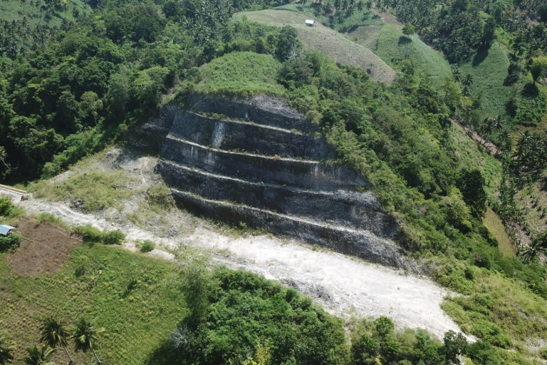
Researchers from Gorontalo State University and elsewhere have identified risks from seismic jolts along the three active faults that run beneath the karst mountains of Gorontalo.
“All the rocks in our study are limestone, which can trigger landslides,” said Fauzul Chaidir A. Usman, a geologist at Gorontalo State University.
Numerous landslides occurred around the construction area between 2014 and 2017. One such landslip, on Dec. 1, 2016, destroyed a 150-kilowatt electricity pylon.
Adhan Dambea, a legislator in the provincial parliament, said much of the environmental damage had already been done by construction of the earlier segments of the road.
“Many natural forests and mountains have fallen victim to this project,” he said.
Bappeda’s Budiyanto said that if the remainder of the road were to proceed through protected forest, the government could obtain a “borrow-use” permit from the environment ministry.
But not everyone is supportive of borrowing an area of protected forest to complete Gorontalo’s long-delayed road.
“How do you borrow a protected forest to build a road? Is the forest going to come back after you get rid of the road?” Adhan said. “That’s impossible.”

Banner image: Construction of the Gorontalo Outer Ring Road is ongoing, by Sarjan Lahay/Mongabay Indonesia.
This story was reported by Mongabay’s Indonesia team and was first published on our Indonesian site on June 30, 2021.
FEEDBACK: Use this form to send a message to the author of this post. If you want to post a public comment, you can do that at the bottom of the page.