
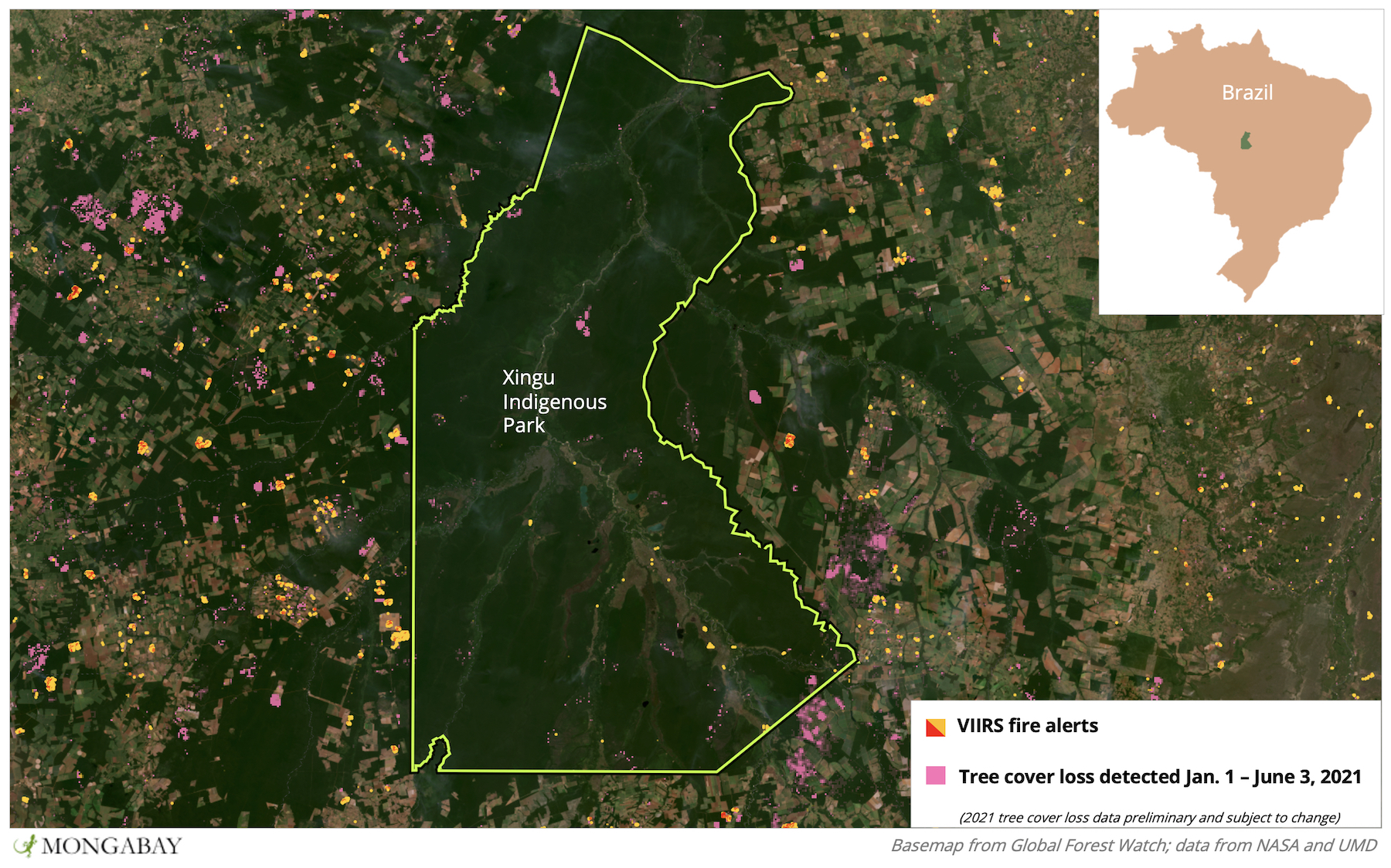
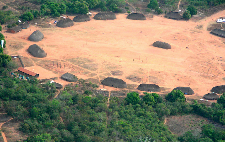
- Xingu Indigenous Park shields one of the last remaining large tracts of old growth rainforest in Brazil’s “arc of deforestation,” and is inhabited by dozens of Indigenous communities.
- The park experienced a jump in deforestation in 2020, quadrupling the amount of primary forest it lost in 2019.
- Most of this deforestation was caused by wildfires, which likely spread from slash-and-burn activity on nearby agricultural fields.
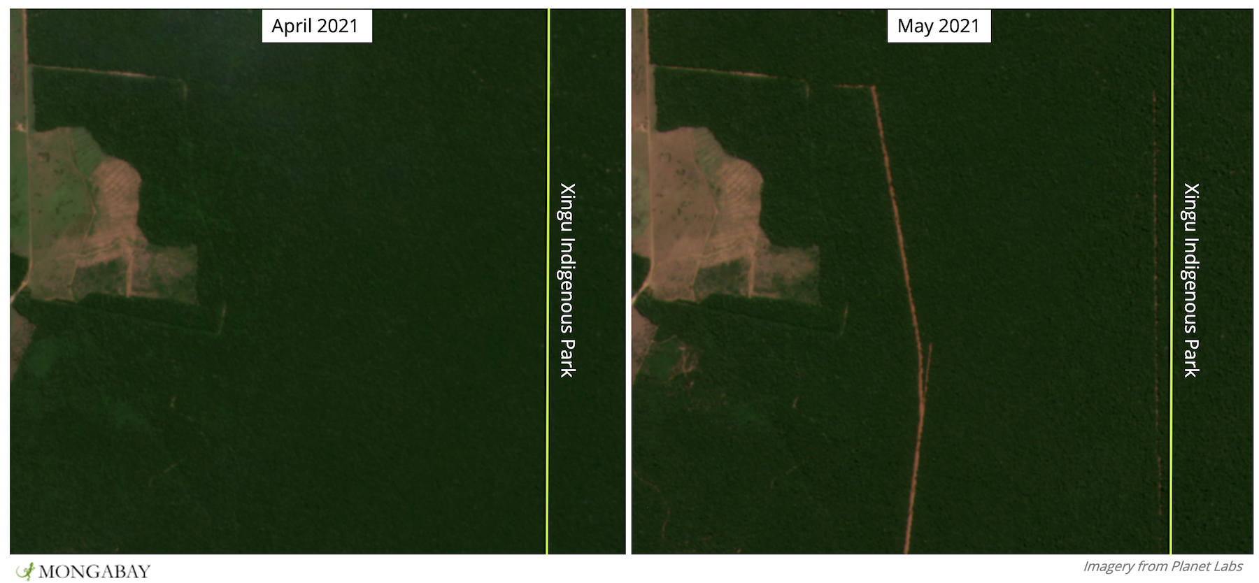
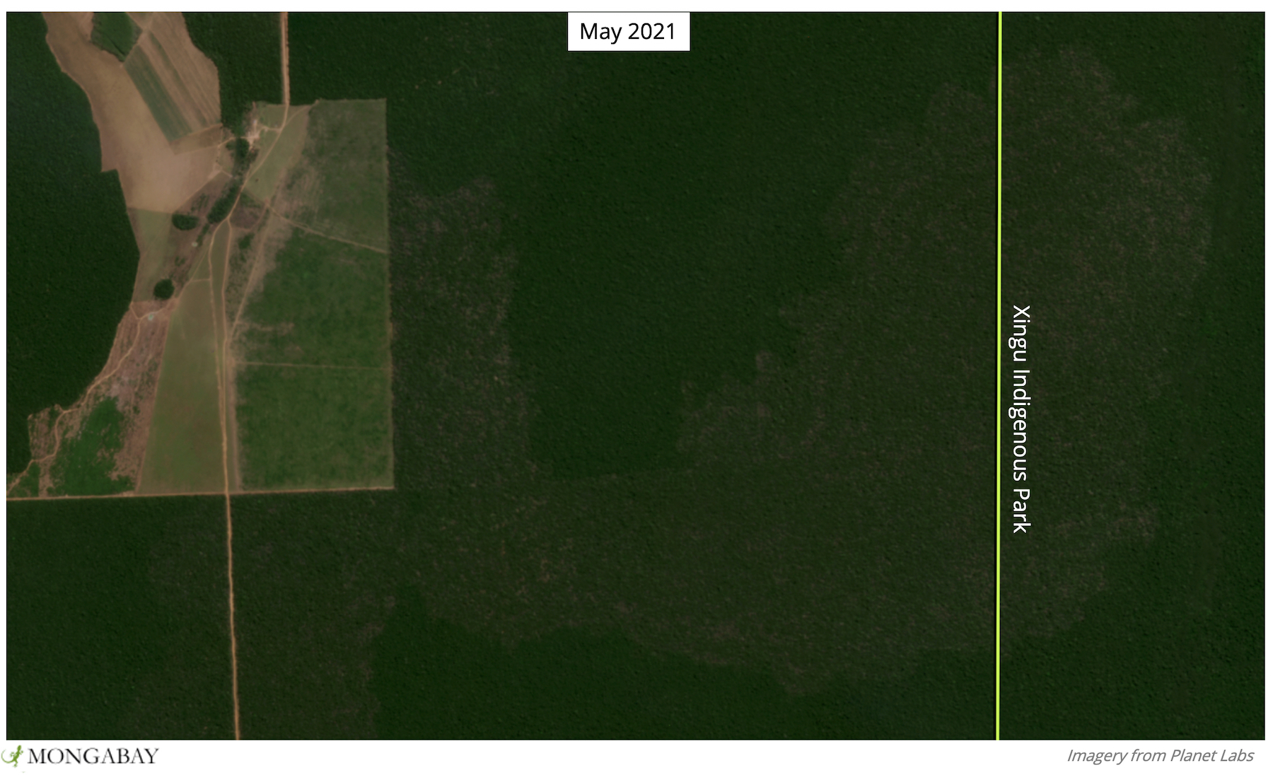
- Satellite data and imagery show agricultural fields and fires expanding towards the park in 2021 despite a prohibition on dry-season burning and a drought the likes of which haven’t been seen in nearly a century.
Situated deep in the middle of Brazil, Xingu Indigenous Park encompasses some of the most biodiverse rainforest in the country and is home to dozens of Indigenous communities and a multitude of wildlife. It also sits in the country’s infamous “Arc of Deforestation,” a vast swath of land heavily degraded by industrial agriculture that stretches from one side of Brazil to the other and which is punctuated in just a few places by islands of protected forest.
But even though Xingu Indigenous Park has been spared much of the deforestation that surrounds it, data show forest loss in the park increased in 2020 as fires, often associated with deforestation for agriculture, consumed portions of its old growth forest. More recently, satellite data and imagery show clearing encroaching closer and closer to the park – including right along its border – as well as fires starting to break out within the park itself.
Xingu Indigenous Park is located in the state of Mato Grosso and straddles the upper portion of the Xingu River, a remote region and one of the Brazil’s last to fall to European colonization. But despite its inaccessibility from the outside world, the Upper Xingu was heavily inhabited by Indigenous communities connected to each other by roads and bridges.
In 1961, what would become Xingu Indigenous Park was demarcated as a national park at the behest of activists and researchers who sought to protect the land for Indigenous inhabitants and scientific study. The move proved a prescient one; by the 1990s, industrial agriculture had invaded much of the surrounding forest.
The park is surrounded by nine municipalities that lost an average of nearly 25% of their primary forest cover between 2002 and 2020, according to data from the University of Maryland (UMD) visualized on Global Forest watch, primarily due to agricultural conversion. Xingu Indigenous Park lost 13% of its primary forest cover during the same period, with data from NASA showing the majority of that loss coincided with an outbreak of forest fires that blitzed through the park in August and September 2016.
Like in most of the municipalities around it, Xingu Indigenous Park experienced a jump in deforestation in 2020, quadrupling the amount of primary forest it lost in 2019. As in years past, this appears to have been largely caused by fire. While Xingu park was among the hardest hit, analysis from Monitoring of the Andean Amazon Project (MAAP) revealed 80 fires had damaged portions of Brazil’s Indigenous territories and protected areas by early September last year.
“Historically, Indigenous territories work as a barrier of protection against the advance of deforestation and forest fires, and are vital to impeding total destruction of the environment,” Sonia Guajajara, who leads the Brazil-based Association of Indigenous Peoples (APIB), told Mongabay in 2020.
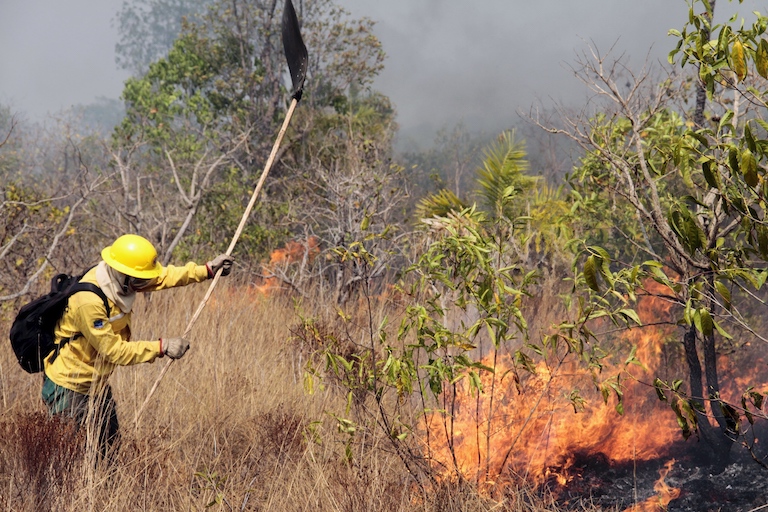
Nearly 80% of the major fires that had burned in the Brazilian Amazon by September 2020 were linked to recent deforestation, according to MAAP. Farmers in the Brazilian Amazon, like elsewhere in the tropics, often burn the land to quickly clear it. But fires don’t always stay where they’re set, particularly when they become too large to control. Even tiny sparks can travel on the wind and beget huge fires in new places – like in nearby protected areas.
Such was the case in the Pantanal, the world’s largest tropical wetland, which lies some 500 kilometers (310 miles) southwest of Xingu park and which experienced multiple massive outbreaks in 2019 and 2020 that burned nearly the entirety of Pantanal Matogrossense National Park.
“Very few of these fires started because of natural causes. The fire that spread and entered into the national park also came from outside. And it ended up burning out of control and entering this conservation unit,” Vinicius Silgueiro, territorial intelligence coordinator at Instituto Centro de Vida (ICV), told Mongabay in 2020.
Burn scars tell a similar story in Xingu Indigenous Park. Satellite images show large swaths of forest burned in 2020 emanating from nearby agricultural fields to protected land within the park.
This year, fire activity appears to be intensifying early as Brazil faces its worst drought in nearly a century. Nine major wildfires had broken out by early June – all in Mato Grosso.
“The rainy season is already finished and it was a bad [dry] rainy season,” Marcelo Seluchi, a meteorologist in Brazil’s national space research institute (INPE) disaster monitoring center told Reuters in May. “The fire season will probably be bad.”
Burning agricultural plots in Mato Grosso is technically only allowed during the rainy season with authorization from the state secretariat for the environment, and is prohibited completely during the dry months when fires are more likely to spread out of control. Sources say, however, that the ban is not always respected and enforcement is lax. This appears to be the case right outside Xingu Indigenous Park, where NASA data and satellite imagery show fires burning as recently as June 8.

Environmentalists say anti-Indigenous policies and environmental agency budget cuts under far-right president Jair Bolsonaro are adding fuel to the flames and creating a climate of impunity.
“The weakening of environmental agencies ends up giving a green light to this activity,” Silgueiro told Mongabay in 2020. “Because, for those who are using fire or deforesting, they don’t worry about getting a fine, they don’t worry that they will be held responsible. So it sends a message that nothing will happen to whoever does this.”
Banner image: A fire burns in Xingu Indigenous Park in 2016. Image by Ibama via Wikimedia Commons (CC BY-SA 2.0).
Editor’s note: This story was powered by Places to Watch, a Global Forest Watch (GFW) initiative designed to quickly identify concerning forest loss around the world and catalyze further investigation of these areas. Places to Watch draws on a combination of near-real-time satellite data, automated algorithms and field intelligence to identify new areas on a monthly basis. In partnership with Mongabay, GFW is supporting data-driven journalism by providing data and maps generated by Places to Watch. Mongabay maintains complete editorial independence over the stories reported using this data.
Feedback: Use this form to send a message to the editor of this post. If you want to post a public comment, you can do that at the bottom of the page.