
- An expansive clearing of primary forest has been detected in Tapajós Environmental Protection Area in the Brazilian Amazon, possibly driven by illegal mining activities.
- Satellite imagery from Planet confirms that the deforestation, which covers around 1,250 hectares (3,090 acres), or an area the size of a large international airport, occurred between January and February of this year.
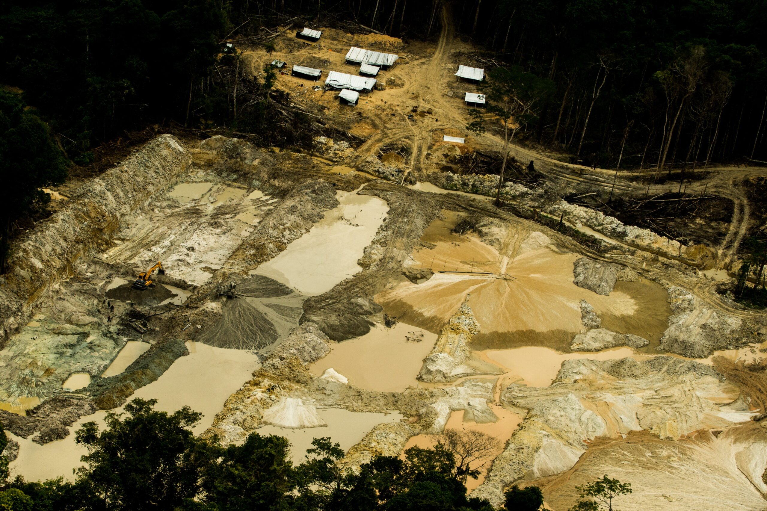
- Mining activity is the suspected driver of this forest loss, as the cleared area surrounds a long-standing feature resembling an airstrip and partially overlaps a proposed gold mining concession.
- Several bills are pending in both Brazil’s houses of Congress that would, if approved, create loopholes for mining on Indigenous territories and grant amnesties to land grabbers.
An expansive clearing of primary forest has been detected in a protected area in the Brazilian Amazon, possibly driven by illegal mining activities.
In March, the Global Land Analysis and Discovery (GLAD) lab at the University of Maryland detected an area of newly cleared forest in the Tapajós Environmental Protection Area, west of the town of Novo Progresso in the state of Pará. Satellite imagery from Planet Labs confirms that the deforestation, which covers around 1,250 hectares (3,090 acres), or an area the size of a large international airport, occurred between January and February of this year.

Mining activity is the suspected driver of this forest loss, as the cleared area surrounds a long-standing feature resembling an airstrip, and many instances of airstrips alongside mining areas can be found throughout the surrounding landscape. The area also partially overlaps gold mining concessions “in application” according to data from Brazil’s National Department of Mineral Production visualized on Global Forest Watch.


The recently cleared region is within an area of the Tapajós-Xingu moist forest that has overall high biodiversity intactness, according to the U.N. Environment Programme’s World Conservation Monitoring Centre. It is also classified as a key biodiversity area by BirdLife International.
The Tapajós Environmental Protection Area falls under the designation of a “protected landscape,” which in Brazil means an area with cultural, ecological or biological importance that has been shaped by humans. For-profit activities such as logging or mining concessions are allowed within a protected landscape, depending on the management plan of the region.
However, according to Human Rights Watch, the Tapajós Basin is an “epicenter of illegal gold mining in the Amazon rainforest.” The Munduruku Indigenous people who live in the basin have reported increasing illegal mining encroachments on their lands in southwestern Pará by armed wildcat miners known as garimpeiros since March this year.
Mining poses significant health threats to surrounding and downstream people and ecosystems beyond the effects of deforestation. It has “been linked to dangerous levels of mercury poisoning, from mercury widely used to process the gold, in several Munduruku communities along the Tapajós basin,” HRW reports.
The Tapajós River Basin supplies an expanding market for crops, cattle and natural resources such as gold. The completion of the Ferrogrão railroad in 2019, which been called a “vector of devastation” by Amazon Watch, has allowed for the transportation of goods, people and infrastructure in and out of the area, further stoking deforestation and illegal activity.
Recent illegal deforestation and illegal mining in the Brazilian Amazon have been blamed on the administration of President Jair Bolsonaro. Since he took office in 2019, deforestation in Brazil has increased by nearly 50%, reaching a 12-year high. In 2020, the state of Pará had the highest rates both of deforestation and fires of any state in Brazil.
“The Bolsonaro administration has weakened the agencies tasked with protecting the environment, effectively emboldening criminal networks involved in illegal logging and mining, among others, in the Amazon,” HRW says.
“The forest is vulnerable and things have been getting worse for some years now,” Paulo Barreto, a researcher from Imazon, an independent Brazilian NGO, told Amazon Watch. “Even worse during the current administration.”
Several bills are pending in both Brazil’s lower and upper houses of Congress that would, if approved, create loopholes for mining on Indigenous territories and grant amnesties to land grabbers.
“This signaling and expectation that the government will approve mining in the [Indigenous territories] increases the number of invaders and degraded areas,” Camila Ramos, a researcher from the National Institute of Amazonian Research, told Amazon Watch. “These invaders deceive and coerce Munduruku Indigenous people to cooperate and participate in mining activities, leading to the swift destruction of the forest.”
Banner image: Deforestation (GLAD) alerts from March 2021. Screenshot from Global Forest Watch.
Editor’s note: This story was powered by Places to Watch, a Global Forest Watch (GFW) initiative designed to quickly identify concerning forest loss around the world and catalyze further investigation of these areas. Places to Watch draws on a combination of near-real-time satellite data, automated algorithms, and field intelligence to identify new areas on a monthly basis. In partnership with Mongabay, GFW is supporting data-driven journalism by providing data and maps generated by Places to Watch. Mongabay maintains complete editorial independence over the stories reported using this data.
Feedback: Use this form to send a message to the editor of this post. If you want to post a public comment, you can do that at the bottom of the page.