
- Thousands of Indigenous, quilombola, and traditional communities live in the Cerrado, the world’s most biodiverse tropical savanna. But many lack access to official titles and deeds, and are not registered on official maps.
- As the agricultural frontier pushes into the northern part of the savanna, land-grabbing and violent attacks are increasing. Many of these communities risk losing their land and their resources upon which they depend.
- Now, a new smartphone app developed in collaboration with communities in the northern Cerrado and two Brazilian NGOs allows communities themselves to register their lands on the app, as well as important local sites and conflicts with farmers and land-grabbers.
- The developers of the app aim to halt the rapid and unequal development that threatens the lives and livelihoods of those working to protect the savanna, and ultimately help conserve the last remaining tracts of native Cerrado.

Veronica Tavares Batista is only 19 years old, but has seen more conflicts over land than most people will ever see in their lifetime.
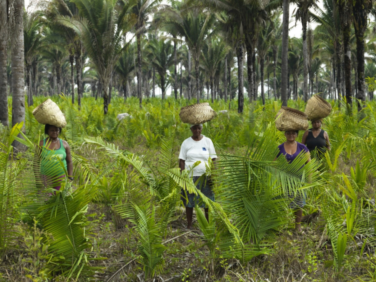
Her home of Brejo de Miguel is a traditional community located on the banks of the Uruçuí Vermelho River in the south of Piauí, a Brazilian state in the northeast of the country. Here, the river flows lazily over earth so rich with clay it turns the waters red, and clusters of palms grow in the wetlands and swamps that it feeds. The residents pick buriti and macaúba, small grenade-shaped fruit that grow clustered high up in the palm trees. They have lived sustainably off their fields of cassava and cattle and the abundance of resources in the Cerrado, the Brazilian savanna, for generations. But as industrial agriculture pushes further northward into the savanna, claiming the land and destroying the resources used by traditional communities, that lifestyle — along with the Cerrado itself — is now at risk of disappearing.
“For some time now, we have had many conflicts and many fences have been put in place that prevent cattle from moving, and prevent us from harvesting things like grass,” says Batista in an interview with Mongabay. “In our community they have already cut fence wire, sawed posts, in addition to the theft of the land itself.” The land grabbers she refers to are intimately connected to the rapid northward expansion of the agricultural frontier, which has now landed both figuratively and literally at her family’s front door.
Batista’s family’s land is in the northern region of the Cerrado. The sprawling tropical savanna covers more than 20% of Brazil’s landmass and runs through the center of the country, bordered to the west by the Amazon and to the east by the Atlantic Forest. Made up of dozens of different kinds of ecosystems, from flat, grassy plains to lush, gallery forests, the Cerrado holds 5% of the world’s biodiversity, thousands of unique species found nowhere else on Earth. But roughly half of the Cerrado’s native vegetation has been lost to agriculture in the last 50 years, and development of the savanna is closely linked to Brazil’s meteoric rise as a leading soybean and cattle exporter. While much of the earlier agricultural development was limited to the south, in the last two decades the agricultural frontier has pushed steadily north, into a region that contains some of the last remaining tracts of native Cerrado vegetation. It is here that agribusiness is increasingly coming into conflict with Indigenous and traditional peoples and communities, many of whom, like Batista’s family, lack formal titles, or are not even shown on official government maps.
Now, a new initiative born from several of these “invisible” communities and in collaboration with two Brazilian NGOs — IPAM and ISPN — is aiming to change that by giving communities the tools to quite literally put themselves on the map, along with their sacred sites, important areas, and the steadily increasing conflicts.
This could also have implications for the conservation of the Cerrado biome, considered a biodiversity “hotspot” because of the combination of high levels of biodiversity and high levels of deforestation or vegetation clearing.
Traditional peoples and communities are “fundamental” to the conservation of the Cerrado, says Isabel Castro, a researcher at the Amazon Environmental Research Institute (IPAM), one of the NGOs that helped launch the Tô no Mapa smartphone application. Now only around 20% intact Cerrado vegetation remains, much of it in this final agricultural frontier.

Layers of inequality
When people think of savannas, most think of endless grasslands interspersed with the occasional, wizened tree. While this landscape is prominent in the Cerrado, dozens of other ecosystems also exist, from the dense, lush riparian forests to flat, nutrient-poor mountaintops known as chapadas; from marshy wetlands to dry, fire-dependent landscapes with plants so used to seasonal fires that they have evolved to send new shoots up mere days after fires have passed through. These divergent and unique ecosystems are what have allowed for an abundance of plant and animal species to flourish; more than a third of all species found in the Cerrado are found nowhere else.
But lack of federal protection for the biome, along with its growing importance as Brazil’s breadbasket, has meant that deforestation and native vegetation destruction has grown on par with the world’s appetite for cheap meat, just as scientists are figuring out just how important the intact vegetation is. Not only does the Cerrado vegetation sequester much more carbon than researchers previously thought, it is also crucial is regulating rainfall locally and recharging aquifers that serve more than half of Brazil’s population, including its biggest city, São Paulo.
The biodiversity of the Cerrado is reflected, too, in the traditional peoples and communities that inhabit it. The quebradeiras de coco babaçu are women who live along the border of the Cerrado and the Amazon and make a living harvesting the small, oblong palm nut from collective palm groves. The apanhadores de flores sempre-vivas, “evergreen flower pickers” in English, harvest the various different kinds of flowers that bloom along the mountain ridges in northern Minas Gerais state, in the center of the Cerrado. The brejeiros, like Batista’s family, make their livelihoods off of the dozens of unique fruits and grasses cultivated in the marshes, swamps and wetlands of the Cerrado. And the vazanteiros, barranqueiros and ribeirinhos all have learned to live off the fish and rhythmic flooding of the vast rivers that spring from the Cerrado. They represent just a snapshot of the dozens of different traditional peoples and communities that exist in the savanna.
Much of the current Cerrado conservation debate is centered on conserving native vegetation and slowing the advance of agriculture. But the people who have lived in the Cerrado sustainably for generations are often reduced to a footnote, even as a growing number of studies around the world show that traditional peoples and communities are key players in environmental conservation. Their livelihoods depend on intricately managed systems of communal use and ownership. And as with traditional communities around the world who have lived off the land for generations, many lack deeds or titles or are not even marked on official government maps.
“Brazil’s official data does not show the real number of traditional communities in the Cerrado,” says Isabel Figueiredo, coordinator of the Cerrado and Caatinga Program at ISPN, in an interview with Mongabay. “Many of them are invisible on official government maps.”
As soy, cattle and eucalyptus farmers increasingly seek to use and buy up more land, violent confrontations have grown. This is especially true in Matopiba, an area of roughly 73 million hectares (180 million acres) — double the size of Norway — that expands across the border region between the states of Maranhão, Tocantins, Piauí and Bahía. Here, between 2001 and 2017, soybean production expanded by 310%. The USDA has coined it “Brazil’s last agricultural frontier.”
Batista’s community is in the center of Matopiba, and her experience of rising conflicts mirrors the statistics. According to the Catholic Church’s Pastoral Land Commission, which tracks land conflicts in Brazil, Matopiba saw a 56% increase in reported land conflicts between 2012 and 2016, double the national increase of 21%.
Those conflicts are often violent. Farmers using electrical fences to enclose communal land have electrocuted babassu coconut breakers to death, Afro-descendant quilombolas have complained of poisonings from agricultural runoff, and last year, several members of gerazeiro communities were shot by private guards protecting one of Brazil’s largest soy estates.
Because of the incomplete registration and mapping information, developers and farmers have a loophole to claim land that traditional communities have lived on for generations. “Land titling is one of the main problems affecting traditional communities and this contributes decisively to conflicts,” sociologist Arilson Favareto, professor of sociology at the Federal University of ABC, São Paulo, who has studied land titling conflicts and economic development in Matopiba, told Mongabay. The northern Cerrado states are also some of the poorest in the country, with high economic inequality and a weak judiciary, which makes access to justice and resources difficult and contributes to the rising levels of conflicts, he adds.
Fueling the Cerrado land rush is also land speculation, driven in part by international pension and investment funds, notably Harvard University’s endowment fund and TIAA, the U.S. teachers’ pension fund, both of which, according to several investigations, own significant amounts of land in Matopiba. Land prices have quadrupled in some municipalities, exacerbating land disputes. “What we’re seeing there in Matopiba is a process of advancing capital, the cornering and expulsion of traditional communities and an increase in conflicts,” Acácio Zuniga Leite, a researcher at the Matopiba Observatory of the University of Brasília, previously told Mongabay.
Recent reports have also shown that the use of georeferencing, increasingly adopted by the government to register lands, has systematically neglected traditional and communal territories and is reinforcing the inequality.

Making the traditional peoples and communities of the Cerrado visible
For Isabel Figueiredo, who has worked with traditional peoples and communities in the Cerrado for more than a decade, the absence of these communities on official maps is glaring. When the government proposed developing Matopiba into a new agricultural region in 2015, Figueiredo remembered being in a meeting with various government agencies. One participant showed a map of Matopiba that was essentially empty. “He showed this map and said ‘Look, there is no one here, there is nothing here, let’s develop it for agribusiness,’” she remembers. But she knew there were hundreds, if not more, communities there. So she partnered with IPAM, an organization that works, among other things, with geospatial data, to create the “invisible communities” mapping project.
From July 2018 to December 2019, they conducted meetings in strategic locations around Matopiba, drawing communities from all over to participate in mapping workshops.
“We did this project only for the Matopiba region, which represents only 16% of the Cerrado and already reached some impressive numbers,” says Raisa Pina, the communications lead for the Institute for Society, Population and Nature (ISPN), in an interview with Mongabay. “We were able to count more than 2,000 communities that previously didn’t exist on government maps just in this one area. Imagine how many more there must be in the Amazon, the rest of the Cerrado, and the Caatinga biome who are threatened by the growth of agribusiness.”
The first step was to figure out which communities were registered officially in government records. After tallying all the communities registered on government websites, documents and maps, they found that 667 communities officially existed in Matopiba. Then came the hard part: figuring out how many other communities existed. Using participatory mapping, evidence from partner organizations around Matopiba, and secondary literature review, the project found that there were 1,731 additional communities that were unregistered in Matopiba, meaning that there were 3.5 times as many communities than the government records showed.
“According to the government, there was no one living there,” Pina says. Using the data collected during the workshops, they were able to show the areas with greater territorial conflict and show where agricultural advancement was occurring the fastest. They were also able to predict where conflicts would break out if clearing happened at the same pace.
For the residents who participated, the experience left a mark.
“At the workshops we were able to see that we were forgotten on the map,” Batista said. “We were invisible.” She, along with other participants, wanted to know whether it was possible to create a tool by which they could register their own communities themselves.
The creation of the app
The outcome of the project was the creation of the smartphone app Tô no Mapa, a phrase that in Portuguese translates to: “I’m on the map.” The app allows communities to register where the community is and also register conflicts — from pollution of water sources to important communal sites.
“The community consensus was that there was a need for mapping — not to map the family unit, but the community itself,” Francisco José Souza Rocha, a research technician at IPAM who helped conceive of the Tô no Mapa app, told Mongabay. Privacy is a big concern, he said, and the community maintains control over the information. While anyone can download the app, information can only be added by communities via specific community protocols. “Part of the process of mapping is meeting as a community, discussing whether they want to map their communities and what they want to map, taking minutes, and forwarding it with the application saying that they agree with this,” he says. The app includes templates for taking meeting minutes and adhering to community guidelines as well as videos on how to effectively use the app.
For mapping experts, this kind of community control and consensus is crucial to any kind of community mapping project.
“Just mapping in isolation without considering governance and how decisions are being made can be dangerous,” Emily Jacobi, co-founder and executive director of Digital Democracy, an organization that works with marginalized communities to use technology to defend their rights, told Mongabay in an interview. The organization assisted the Indigenous Waoroni of Ecuador in creating the participatory map that was used successfully in their court case against oil drilling in their territory in 2019, but isn’t involved with the Tô no Mapa initiative.
Jacobi says that, instead of disrupting local governance procedures, maps should be built around them. In working with various different types of communities, she has found that those mapping initiatives that stem from communities themselves, rather being forced upon them from the outside, are often the ones that work best.
At the same time, “often if people want to collaborate they have a much larger threat — agribusiness, mining, or oil drilling — that is coming in that could vastly disrupt their lives, deforest their home, and lead to the demise of their culture,” Jacobi says. “These kind of technological tools are not just critical but also can make the difference between whether that future comes to pass or if they can actually hold those things off.”
For Figueiredo and her colleagues, the current focus is on expanding the app to all the communities in Matopiba, including the ones that were not involved in the original workshops. “We have a very complex strategy to bring information into the app,” she told Mongabay. They’re conducting workshops with partners like Instituto Cerrados, as well as in rural schools, social movements, and key communities in the region. They’re also actively applying for funds to have a dedicated point person available to answer questions and address problems.
Even though the map is not official, the developers of the app say that giving communities power to gather and add information directly, and creating a large, secure database, will be a useful tool to confront the government and eventually also help secure land rights.
The initiative is also a crucial step for maintaining the biodiversity that remains. “In the Cerrado there are few protected areas and private land is very expensive,” Figueiredo says. It is the traditional peoples and communities that are doing and have always done the essential work of conserving the Cerrado’s natural vegetation and biodiversity.
“If want to maintain the Cerrado, we have to maintain the traditional peoples and communities,” she says. “There is no question about it.”
Maurício Angelo contributed to this report.
Banner image: These flat-topped ridges called chapadas in Portuguese are common in the Cerrado Highlands. Photo by André Dib / Courtesy of ISPN.