
- The Amazon basin lost more than 2 million hectares of primary forest cover in 2020, according to a new report by the Monitoring of the Andean Amazon Project (MAAP).
- This number is higher than the area lost in 2019 and the authors say it may be an underestimation.
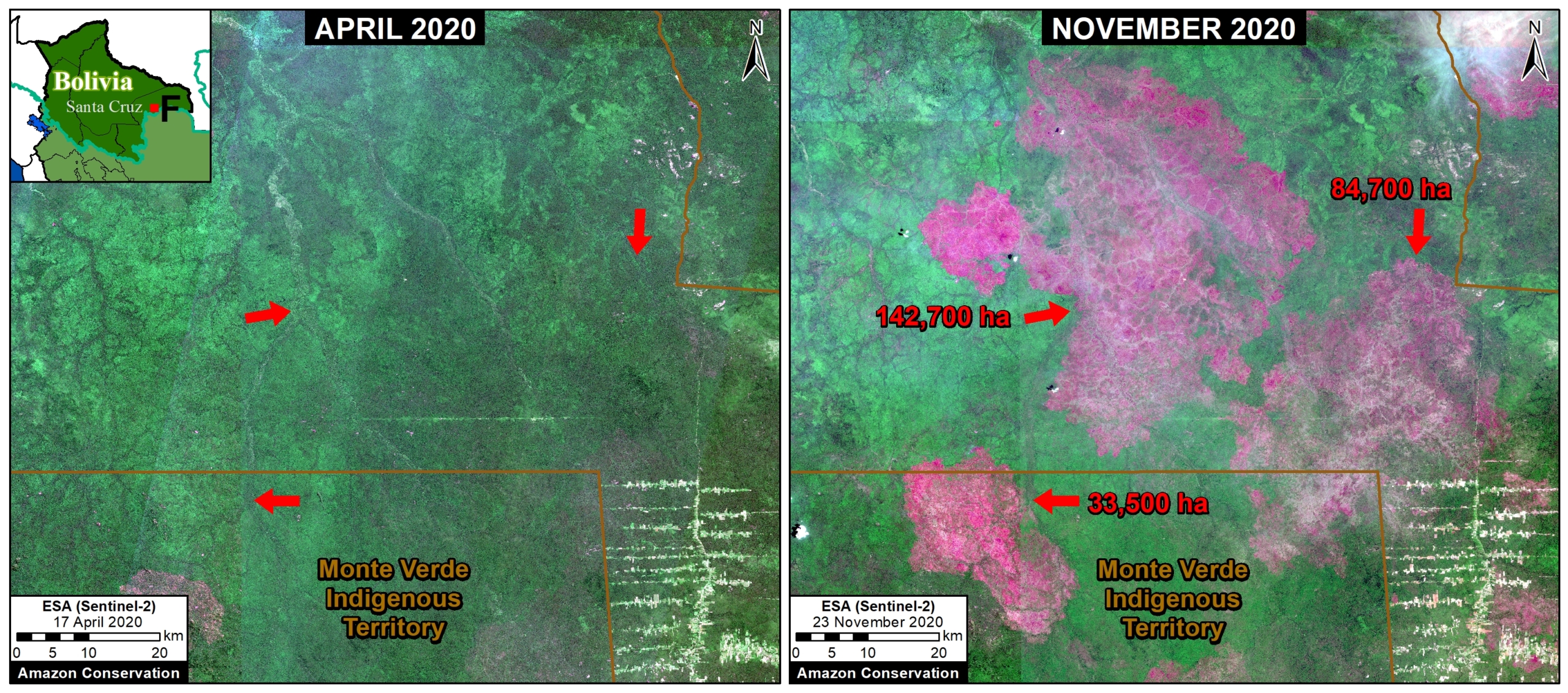
- Brazil lost the most primary forest, with Bolivia experiencing high levels of fire-related deforestation of its unique Chiquitano dry forests.
- While Peru saw continuing deforestation in its midsection, MAAP found reductions in forest loss in the southern part of the country.
The Amazon basin lost more than 2 million hectares of primary forest cover in 2020, according to a new satellite data analysis released today. The authors say this likely eclipses loss in 2019 when 1.7 million hectares was deforested – and is likely even a conservative estimate, meaning that the actual area of forest lost may be larger still.
The analysis was produced by researchers Matt Finer and Sidney Novoa at the Monitoring of the Andean Amazon Project (MAAP), an initiative of a U.S.-based Amazon Conservation and Peru-based Conservación Amazónica along with partners ACEAA in Bolivia and EcoCiencia in Ecuador.

The data MAAP used for their analysis came from the Global Land Analysis and Discovery (GLAD) lab at the University of Maryland (UMD), which compiles preliminary satellite data on tree cover changes in the tropical parts of the world in near-real time. While GLAD data are subject to change after UMD crunches the dataset more thoroughly later this year, MAAP’s estimate for Amazon primary forest loss for 2019 ultimately came out low (1.3 million hectares vs. the final tally of 1.7 million) “indicating that if anything the alerts may be conservative,” Finer said.
In other words, the Amazon may have lost significantly more than 2 million hectares of primary forest last year. But even at 2 million, 2020 was likely a banner year for deforestation.
“Across the Amazon, even though 2019 made more graphic headlines with the fires, our early estimates indicate that 2020 was actually worse in terms of both deforestation and fires,” Finer said.
In addition to a broad overview of the Amazon region, MAAP’s analysis looks into what’s happening on the ground in very specific regions.
“Deforestation often gets very impersonal, stripped down to just numbers,” Finer said. “Here we want to highlight where this deforestation is actually happening and what it really looks like ”
Brazil lost the most primary forest of any Amazon country, with much of this loss focused in the southern Brazilian Amazon along the agro-industrial corridor that’s become known as the “Arc of Deforestation” due to years of extensive clearing for cattle pasture, soy fields and timber. MAAP’s analysis reveals that many areas were initially deforested in the first half of 2020 and then set ablaze in July and August, which follows the pattern of “slash and burn” cultivation common in the tropics.

The analysis shows fires increasingly invaded standing primary forest starting in September. Such events were not isolated to the Brazilian Amazon region, with catastrophic fires breaking out in other parts of the country. In October and November vast fires swept through the Pantanal – the world’s largest tropical wetland, most of which lies in Brazil; sources say fires started to clear cropland grew out of control, and that the situation was fostered by weakened environmental regulations.


For the second year in a row, Bolivia was racked by heavy fire activity. MAAP estimates the beleaguered Chiquitano dry forests in the eastern part of the country lost another 260,000 hectares of primary forest cover. Once considered the planet’s “best-preserved tropical dry forest,” the Chiquitano is home to a bevy of wildlife, including the most mammal species in the ecoregion – 26% of which are threatened with extinction.
To the north, MAAP shows a wall of deforestation advancing deeper into the Colombian Amazon. This clearing – driven largely by the expansion of cattle pasture as well as coca crops for the cocaine trade – is invading protected areas, including Chiribiquete National Park which MAAP estimates lost around 500 hectares in 2020. Colombia’s largest national park, Chiribiquete was expanded in 2018 in an effort to better protect the region’s forest and the Indigenous communities and wildlife that depend on it.

In Peru, deforestation continues in the country’s midsection. In previous analyses, MAAP found forest loss in the region was driven primarily by the expansion of cattle pasture and small- and medium-scale cropland.

However, the MAAP team also found one “positive” note: a drop in forest loss in southern Peru. For years, gold deposits under the rainforest around Puerto Maldonado have lured hungry prospectors to the region, and an area of rainforest the size of New York City has been destroyed since 2009 as they dredged, scoured, crushed and sieved the earth beneath. But government intervention appears to have worked, with MAAP finding illegal mining-related deforestation in the Peruvian Amazon declined 78% after a major crackdown dubbed “Operation Mercury” in early 2019.
After years of forest loss, “gold mining deforestation finally wasn’t a major hotspot in southern Peru [in 2020] thanks to Operation Mercury,” Finer said.
Banner image by Rhett Butler/Mongabay.
Feedback: Use this form to send a message to the editor of this post. If you want to post a public comment, you can do that at the bottom of the page.